Quebec Route 234
Highway in Quebec
Major junctions R-232 in Saint-Narcisse-de-Rimouski
 R-298 in Saint-Gabriel-de-Rimouski
  R-132 in Sainte-Angele-de-Merici R-132 in Grand-Métis
- Quebec provincial highways
←  R-233 R-233 | →  R-235 R-235 |
Route 234 is a provincial highway located in the Bas-Saint-Laurent region in the southeastern part of the province of Quebec. The highway runs from the junction of Route 232 in Saint-Narcisse-de-Rimouski and ends at the junction of Route 132 near Grand-Métis. The route runs concurrently with Highway 298 through Saint-Gabriel-de-Rimouski and then with Highway 132 near Sainte-Angele-de-Merici near the northwestern part of the 132 loop around the Gaspé Peninsula.
Municipalities along Route 234
- Saint-Narcisse-de-Rimouski
- Saint-Marcellin
- Saint-Gabriel-de-Rimouski
- Sainte-Angèle-de-Mérici
- Grand-Métis
-
 Route 234 entering Saint-Marcellin.
 -
 Wooden street blades on Route 234 in Saint-Gabriel.
 -
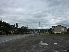 Route 234 in Sainte-Angèle-de-Mérici.
 -
 Route 234 seen in eastbound direction near Price, Quebec.


See also
References
- ^ Ministère des transports, "Distances routières", page 86, Les Publications du Québec, 2005
External links
- Official Transports Quebec Road Network Map (in French)
- Route 234 on Google Maps
- v
- t
- e
 | This Quebec road, road transport or highway-related article is a stub. You can help Wikipedia by expanding it. |
- v
- t
- e


