São Luiz Gonzaga
Municipality in Rio Grande do Sul, Brazil
Flag

Coat of arms
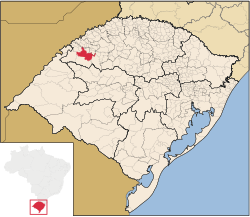
Location in Rio Grande do Sul state
 Brazil
 (2020 [1])
São Luiz Gonzaga (Portuguese for St. Aloysius Gonzaga) is a municipality of the state of Rio Grande do Sul, Brazil. Its population is 33,293 (2020 est.) in an area of 1295,68 km2.[2] It was founded in the 17th century as a Jesuit mission town. It is located 503 km west of the state capital of Porto Alegre, northeast of Alegrete.
Climate
São Luiz Gonzaga has a humid subtropical climate (Köppen: Cfa) with hot summers, mild winters, and ample rainfall throughout the year.
| Climate data for São Luiz Gonzaga (1991–2020) | |||||||||||||
|---|---|---|---|---|---|---|---|---|---|---|---|---|---|
| Month | Jan | Feb | Mar | Apr | May | Jun | Jul | Aug | Sep | Oct | Nov | Dec | Year |
| Mean daily maximum °C (°F) | 32.7 (90.9) | 31.9 (89.4) | 30.5 (86.9) | 27.6 (81.7) | 23.1 (73.6) | 21.1 (70.0) | 20.7 (69.3) | 23.3 (73.9) | 24.6 (76.3) | 27.4 (81.3) | 30.1 (86.2) | 32.1 (89.8) | 27.1 (80.8) |
| Daily mean °C (°F) | 26.0 (78.8) | 25.2 (77.4) | 23.8 (74.8) | 21.1 (70.0) | 17.3 (63.1) | 15.6 (60.1) | 14.9 (58.8) | 16.9 (62.4) | 18.2 (64.8) | 21.0 (69.8) | 23.3 (73.9) | 25.4 (77.7) | 20.7 (69.3) |
| Mean daily minimum °C (°F) | 20.6 (69.1) | 20.1 (68.2) | 18.8 (65.8) | 16.4 (61.5) | 13.3 (55.9) | 11.8 (53.2) | 10.8 (51.4) | 12.2 (54.0) | 13.3 (55.9) | 15.9 (60.6) | 17.4 (63.3) | 19.7 (67.5) | 15.9 (60.6) |
| Average precipitation mm (inches) | 170.6 (6.72) | 158.4 (6.24) | 156.4 (6.16) | 194.3 (7.65) | 168.6 (6.64) | 132.7 (5.22) | 124.1 (4.89) | 104.6 (4.12) | 146.6 (5.77) | 264.4 (10.41) | 169.7 (6.68) | 199.0 (7.83) | 1,989.4 (78.32) |
| Average precipitation days (≥ 1.0 mm) | 8.5 | 8.3 | 7.7 | 8.0 | 8.4 | 7.8 | 8.0 | 6.9 | 8.1 | 11.0 | 7.6 | 8.6 | 98.9 |
| Average relative humidity (%) | 68.0 | 71.2 | 72.5 | 73.3 | 76.7 | 77.9 | 75.1 | 70.2 | 70.6 | 71.0 | 64.1 | 64.6 | 71.3 |
| Average dew point °C (°F) | 20.3 (68.5) | 20.4 (68.7) | 19.3 (66.7) | 16.8 (62.2) | 13.8 (56.8) | 12.3 (54.1) | 10.9 (51.6) | 11.8 (53.2) | 13.3 (55.9) | 16.1 (61.0) | 16.8 (62.2) | 18.9 (66.0) | 15.9 (60.6) |
| Mean monthly sunshine hours | 220.9 | 196.4 | 214.9 | 185.2 | 161.3 | 126.0 | 153.0 | 172.1 | 161.0 | 176.2 | 212.7 | 216.9 | 2,196.6 |
| Source: NOAA[3] | |||||||||||||
Bounding municipalities
- Roque Gonzales
- Rolador
- Caibaté
- São Miguel das Missões
- Bossoroca
- Santo Antônio das Missões
- São Nicolau
- Dezesseis de Novembro
References
External links
- http://www.citybrazil.com.br/rs/saoluizgonzaga/ (in Portuguese)
- v
- t
- e

Capital: Porto Alegre
Mesoregion Centro Ocidental Rio-Grandense | |||||||
|---|---|---|---|---|---|---|---|
| |||||||

Mesoregion Metropolitana de Porto Alegre | |||||||||||||
|---|---|---|---|---|---|---|---|---|---|---|---|---|---|
| |||||||||||||
Mesoregion Nordeste Rio-Grandense | |||||||
|---|---|---|---|---|---|---|---|
| |||||||
Mesoregion Noroeste Rio-Grandense | |||||||||||||||||||||||||||
|---|---|---|---|---|---|---|---|---|---|---|---|---|---|---|---|---|---|---|---|---|---|---|---|---|---|---|---|
| |||||||||||||||||||||||||||
Mesoregion Sudeste Rio-Grandense | |||||||||
|---|---|---|---|---|---|---|---|---|---|
| |||||||||
Mesoregion Sudoeste Rio-Grandense | |||||||
|---|---|---|---|---|---|---|---|
| |||||||
Authority control databases | |
|---|---|
| International |
|
| National |
|
 | This geographical article relating to Rio Grande do Sul is a stub. You can help Wikipedia by expanding it. |
- v
- t
- e


