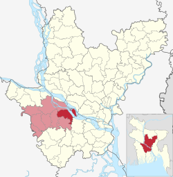
Sadarpur Upazila
Upazila in Dhaka, Bangladesh
Sadarpur সদরপুর | |
|---|---|
Upazila | |
 | |
| Coordinates: 23°28.6′N 90°2′E / 23.4767°N 90.033°E / 23.4767; 90.033 | |
| Country |  Bangladesh Bangladesh |
| Division | Dhaka |
| District | Fardipur |
| Area | |
| • Total | 261.29 km2 (100.88 sq mi) |
| Population (2011) | |
| • Total | 186,254 |
| • Density | 710/km2 (1,800/sq mi) |
| Time zone | UTC+6 (BST) |
| Website | sadarpur |
Sadarpur (Bengali: সদরপুর) is an upazila of Faridpur District in the Division of Dhaka, Bangladesh.[1]
Geography
Sadarpur is located at 23°28′35″N 90°02′00″E / 23.4764°N 90.0333°E / 23.4764; 90.0333 and has 40,219 households and a total area of 261.29 km2.
Demographics
| Religions in Sadarpur upazila (2011)[2] | ||||
|---|---|---|---|---|
| Religion | Percent | |||
| Islam | 94.35% | |||
| Hinduism | 5.65% | |||
As of the 2011 Bangladesh census, Sadarpur upazila had 40,219 households and a population of 186,254. 46,229 (24.82%) were under 10 years of age. Sadarpur had an average literacy rate of 43.18%, compared to the national average of 51.8%, and a sex ratio of 1077 females per 1000 males. 6,076 (3.26%) of the population lived in urban areas.[2][3]
Administration
Sadarpur Upazila is divided into nine union parishads: Akter Char, Bhashanchar, Char Bishnupur, Char Manair, Char Nasirpur, Dheukhali, Krishnapur, Narikelbaria, and Sadarpur. The union parishads are subdivided into 88 mauzas and 328 villages.[2]
The postal code is 7820.
See also
- Upazilas of Bangladesh
- Districts of Bangladesh
- Divisions of Bangladesh
References
- ^ Reza, Masud (2012). "Sadarpur Upazila". In Islam, Sirajul; Jamal, Ahmed A. (eds.). Banglapedia: National Encyclopedia of Bangladesh (Second ed.). Asiatic Society of Bangladesh.
- ^ a b c "Bangladesh Population and Housing Census 2011 Zila Report – Faridpur" (PDF). bbs.gov.bd. Bangladesh Bureau of Statistics.
- ^ "Community Tables: Faridpur district" (PDF). bbs.gov.bd. Bangladesh Bureau of Statistics. 2011.
- v
- t
- e


 | This Dhaka Division location article is a stub. You can help Wikipedia by expanding it. |
- v
- t
- e


