Saint Helena Sound
Coastal inlet in South Carolina

Saint Helena Sound is a coastal inlet in the Lowcountry region of South Carolina, located along the Atlantic Ocean between Beaufort and Colleton counties. Located within the relatively undeveloped ACE Basin, the sound consists of the mouths of the Ashepoo, Combahee, and the south branch of the Edisto rivers, of which the ACE moniker derives from. The inlet is located 15-mile (24 km)east of Beaufort, between Edisto Island and Hunting Island. At its widest point, Saint Helena Sound is 7.5-mile (12.1 km) across.[1] The Intracoastal Waterway crosses the sound. Much of the land surrounding St. Helena Sound has been preserved through the St. Helena Sound Heritage Preserve and the larger ACE Basin project.
See also
- ACE Basin
- St. Helena Sound Heritage Preserve
- Waterways forming and crossings of the Atlantic Intracoastal Waterway
- List of rivers of South Carolina
- List of rivers of the Americas by coastline
References
- ^ Columbia University Press. "Saint Helena Sound". Barleby. Archived from the original on 3 March 2006. Retrieved 2 November 2006.
- v
- t
- e
| National Parks | |
|---|---|
| National Historic Sites and Historical Parks | |
| National Military Parks and Battlefields | |
| National Historic Trail | |
| National Forests | |
| National Wildlife Refuges | |
| National Estuarine Research Reserves | |
| Wilderness Areas |
|
| Wild and Scenic River |
| State Parks |
|
|---|---|
| State Historic Sites | |
| State Forests |
|
| Heritage Preserves |
|
| Wildlife Management Areas |
|
| Seabird Sanctuaries |
|
The Lowcountry of South Carolina | ||
|---|---|---|
| Counties | 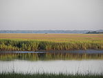 | |
| Major communities | ||
| Sea islands |
| |
| History & culture |
| |
| Military installations | ||
| Natural areas | ||
| Other articles |
| |
Authority control databases | |
|---|---|
| International |
|
| National |
|
32°27′17″N 80°26′25″W / 32.45472°N 80.44028°W / 32.45472; -80.44028
 | This South Carolina state location article is a stub. You can help Wikipedia by expanding it. |
- v
- t
- e


