San Luis Rey, Oceanside, California
Neighborhood in Oceanside, California, United States
Neighborhood of Oceanside in San Diego, California, United States
San Luis Rey | |
|---|---|
Neighborhood of Oceanside | |
 | |
33°13′55″N 117°19′25″W / 33.23194°N 117.32361°W / 33.23194; -117.32361 | |
| Country | United States |
| State | California |
| County | San Diego |
| Elevation | 59 ft (18 m) |
| Time zone | UTC-8 (Pacific (PST)) |
| • Summer (DST) | UTC-7 (PDT) |
| ZIP code | 92068 |
| Area code(s) | 442 & 760 |
| GNIS feature ID | 1661386[1] |
San Luis Rey (Spanish for "St. Louis the King") is a neighborhood in Oceanside, California. San Luis Rey is along the San Luis Rey River, 4 miles (6.4 km) northeast of downtown Oceanside. San Luis Rey has a post office with ZIP code 92068, which opened in 1861.[2]
History
Quechla / Qée'ish
The area that is now known as San Luis Rey was originally home to Payómkawichum, or the Luiseño.[3] The Payómkawichum had a village of 5,000 people which was called Quechla or Qée'ish depending on dialect.
San Luis Rey
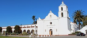
The community was named for Mission San Luis Rey de Francia, established in 1798,[4] which is located near the geographic center of the neighborhood.[5] The population of Quechla dropped down to 3,000 people soon after the establishment of the Mission due to diseases brought by the Spanish. This Mission at one point covered 950,000 acres and was tended by the Luiseño Indians, who were forcibly moved onto the Mission to work under the Spanish.[3] Due to the extensive and long-lived influence of the Spanish and later the Mexican government, local architecture has taken on a noticeable Spanish and Mexican feel.
Neighborhood of Oceanside
The neighborhood also includes the Heritage Park Village and museum, which was the center of town for the city of Oceanside for a time.[3]
The Lilac Fire broke out on December 7, 2017, severely damaging the 240-acre San Luis Rey Downs horse-training facility and killing 46 horses.[6]
Native American culture
The original residents of the valley now called San Luis Rey were Luiseño Indians, also known as the San Luis Rey Band of the Luiseño Indians. Although in other parts of the United States Native Americans were allowed to live autonomously on reservations, such an arrangement was denied to the Luiseño Indians because the settlers wanted to keep the land for farming and ranching. Native Americans were granted US citizenship in 1924.
Since 1996 the band hosts an annual inter-tribal powwow on the San Luis Rey Mission grounds, which is open to the public and presents Native American arts, crafts, food and dancing. On November 28, in honor of National Native American Heritage Month, the San Luis Rey city Council acknowledged the Mission Indians at its council meeting.[4]
Climate
According to the Köppen Climate Classification system, San Luis Rey has a warm-summer Mediterranean climate, abbreviated "Csa" on climate maps.[7]
Demographics
This community has a notably high percentage of US military personnel due to its close proximity to Camp Pendleton.[3]
Notable people
- Robert C. Frazee, California businessman and politician, was born in San Luis Rey.[8]
References
- ^ "US Board on Geographic Names". United States Geological Survey. October 25, 2007. Retrieved January 31, 2008.
- ^ ZIP Code Lookup
- ^ a b c d "Oceanside Neighborhood Guide: San Luis Rey | YNC". Your North County. January 15, 2014. Retrieved April 13, 2018.
- ^ a b "Oceanside recognizes San Luis Rey Band of Mission Indians – The Coast News Group". Retrieved January 1, 2019.
- ^ Durham, David L. (1998). California's Geographic Names: A Gazetteer of Historic and Modern Names of the State. Quill Driver Books. p. 1339. ISBN 1-884995-14-4.
- ^ Union-Tribune (TNS), Bryce Miller The San Diego. "Anniversary of deadly San Luis Rey Downs fire strains still". Valdosta Daily Times. Retrieved January 1, 2019.
- ^ Climate Summary for San Luis Rey, California
- ^ JoinCalifornia.com.-Robert Frazee
- v
- t
- e
Municipalities and communities of San Diego County, California, United States
County seat: San Diego

- Alpine
- Bonita
- Bonsall
- Borrego Springs
- Bostonia
- Boulevard
- Campo
- Camp Pendleton Mainside
- Camp Pendleton South
- Casa de Oro-Mount Helix
- Crest
- Del Dios
- Descanso
- Elfin Forest
- Eucalyptus Hills
- Fairbanks Ranch
- Fallbrook
- Granite Hills
- Harbison Canyon
- Harmony Grove
- Hidden Meadows
- Jacumba Hot Springs
- Jamul
- Julian
- Lake San Marcos
- Lakeside
- La Presa
- Mount Laguna
- Pala
- Pine Valley
- Potrero
- Rainbow
- Ramona
- Rancho San Diego
- Rancho Santa Fe
- San Diego Country Estates
- Spring Valley
- Valley Center
- Winter Gardens
communities
- 4S Ranch
- Ballena
- Banner
- Casa de Oro
- De Luz
- De Luz Heights
- Dehesa
- Dulzura
- East Otay Mesa
- Flinn Springs
- Foster
- Guatay
- Jesmond Dene
- Kentwood-In-The-Pines
- Lincoln Acres
- Manzanita
- Oak Grove
- Ocotillo Wells
- Pala Mesa
- Palomar Mountain
- Pauma Valley
- Pine Hills
- Ranchita
- Rincon
- San Luis Rey
- Santa Ysabel
- Shelter Valley
- Tecate
- Warner Springs
- Wynola
reservations
- Barona Reservation
- Campo Indian Reservation
- Capitan Grande Reservation
- Ewiiaapaayp Indian Reservation
- Inaja and Cosmit Reservation
- Jamul Indian Village
- La Jolla Indian Reservation
- La Posta Reservation
- Los Coyotes Indian Reservation
- Manzanita Reservation
- Mesa Grande Reservation
- Pala Indian Reservation
- Pauma and Yuima Indian Reservation
- Rincon Indian Reservation
- San Pasqual Reservation
- Santa Ysabel Reservation
- Sycuan Band Reservation
- Viejas Reservation
- California portal
- United States portal
| Authority control databases |
|
|---|


