Shitada, Niigata
Former municipality in Hokuriku, Japan
Shitada  Flag  Seal | |
|---|---|
| Country | Japan |
| Region | Hokuriku |
| Prefecture | Niigata Prefecture |
| District | Minamikanbara District |
| Merged | May 1, 2005 (now part of Sanjō) |
| Area | |
| • Total | 311.00 km2 (120.08 sq mi) |
| Population (2003) | |
| • Total | 11,118 |
| Time zone | UTC+09:00 (JST) |
Shitada (下田村, Shitada-mura) was a village located in Minamikanbara District, Niigata Prefecture, Japan.
As of 2003, the village had an estimated population of 11,118 and a density of 35.75 persons per km2. The total area was 311.00 km2.
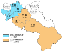
On May 1, 2005, Shitada, along with the town of Sakae (also from Minamikanbara District), was merged into the expanded city of Sanjō.[1][2]
Transportation
Railway
JNR Yahiko Line had been operated in the village until 1984.
Highway


Local attractions
- Yagigahana (ja:八木ヶ鼻)
- Echigo-Nagano Onsen (ja:越後長野温泉)
-
 Echigo-Nagano Onsen Rankeiso

References
- v
- t
- e
Dissolved municipalities of  Niigata Prefecture
 Niigata Prefecture
| 2001 | |
|---|---|
| 2005 |
| 2008 |
|---|
| 2005 |
|---|
| 2003 | |
|---|---|
| 2005 |
| 2004 |
|---|
| 2005 |
|---|
| 2005 |
|---|
| 2006 |
|---|
| 2005 |
|
|---|
| 2005 | |
|---|---|
| 2006 | |
| 2010 |
| 2005 |
|---|
| 2005 |
|---|
| 2004 |
|---|
| 2004 | |
|---|---|
| 2005 |
| 2005 |
|---|
| 2005 |
|
|---|
| 2005 |
|---|
| 2004 |
|---|
Authority control databases | |
|---|---|
| International |
|
| National |
|
 | This Niigata Prefecture location article is a stub. You can help Wikipedia by expanding it. |
- v
- t
- e


