Slievemargy
Barony in County Laois, Ireland
Barony in Leinster, Ireland
Slievemargy Sliabh Mairge (Irish) | |
|---|---|
Barony | |
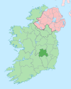
 Barony map of Queen's County, 1900; Slievemargy is pink, in the southeast. | |
| Sovereign state | Ireland |
| Province | Leinster |
| County | Laois |
| Area | |
| • Total | 143.62 km2 (55.45 sq mi) |
Slievemargy (Irish: Sliabh Mairge,[1] IPA: [ʃlʲiə mˠaɾ.ɟə]) is a barony in County Laois (formerly called Queen's County or County Leix), Ireland.[2][3]
Etymology
The barony is named after the large hill partially within its borders. [4][5][6] The name Slievemargy is derived from the Irish name for the hill, Sliabh Mairge, with Sliabh meaning "mountain" and mairge being the genitive declension of mairg, meaning "gloom" or "woe". Thus, the hill's name could be translated as something akin to "mountain of gloom".
The barony's name has multiple spellings; it is also spelled Slieuemargue, Slewmergie, Slieuemargue and Slieuemargy, though these spellings are no longer used in modern times.[7]
Geography
Slievemargy is located to the west of the River Barrow.[8] The hill within the barony has a rather harsh graident/slope, and is said to bear a highest peak approximately 315m above sea level.
History
Slievemargy corresponded roughly to the lordship of Ui Bairrche and was held by the septs O'Treasaigh and MacGorman.[9]
List of settlements
Below is a list of settlements in Slievemargy barony:
- Arless
- Ballickmoyler
- Crettyard
- Killeshin
- Newtown
- The Swan
- Bilblá, County Carlow
References
- ^ "Sliabh Mairge/Slievemargy". Logainm.ie.
- ^ "Slievemargy - Google Search". www.google.ie.
- ^ Patrick, Saint; Press, Aeterna. "The Life and Writings of Saint Patrick". Aeterna Press – via Google Books.
- ^ General Alphabetical Index to the Townlands and Towns, Parishes, and Baronies of Ireland: Based on the Census of Ireland for the Year 1851. Genealogical Publishing Com. 12 July 1984. ISBN 9780806310527 – via Google Books.
- ^ Brewer, James Norris (1826). The Beauties of Ireland: Being Original Delineations, Topographical, Historical, and Biographical, of Each County. Sherwood, Jones, & Company. p. 112 – via Internet Archive.
Slievemargy.
- ^ Sixsmith, Lorna (30 May 2018). Till the Cows Come Home: Memories of a Rural Childhood. Black & White Publishing. ISBN 9781785302053 – via Google Books.
- ^ "The Parliamentary Gazetteer of Ireland: Adapted to the New Poor-law, Franchise, Municipal and Ecclesiastical Arrangements, and Compiled with a Special Reference to the Lines of Railroad and Canal Communication as Existing in 1843-44; Illustrated by a Series of Maps, and Other Plates; and Presenting the Results, in Detail, of the Census of 1841, Compared with that of 1831". A. Fullarton. 12 July 2018 – via Google Books.
- ^ "The Parliamentary Gazetteer of Ireland: Adapted to the New Poor-law, Franchise, Municipal and Ecclesiastical Arrangements, and Compiled with a Special Reference to the Lines of Railroad and Canal Communication, as Existing in 1814-45". A. Fullarton and Company. 12 July 2018 – via Google Books.
- ^ Rev. Patrick Woulfe. "Irish Names and Surnames".
- v
- t
- e
Places in County Laois
County town: Portlaoise
Townlands
- Aghaboe
- Arless
- Ballacolla
- Ballaghmore
- Ballickmoyler
- Ballinakill
- Ballybrittas
- Ballybrophy
- Ballyfin
- Ballyhide
- Ballyhuppahane
- Ballyroan
- Barrowhouse
- Borris-in-Ossory
- Castletown
- Clonaghadoo
- Clonaslee
- Crettyard
- Cullohill
- Coolrain
- Donaghmore
- Durrow
- Emo
- Errill
- Jamestown
- Kilbricken
- Killenard
- Killeshin
- Middlemount
- New Inn
- Newtown
- Raheen
- Rathdowney
- Rosenallis
- Shanahoe
- Sletty
- Spink
- Stradbally
- The Swan
- Timahoe
- Vicarstown
- List of townlands in County Laois
- Category:Mountains and hills of County Laois
- Category:Rivers of County Laois
- Category:Geography of County Laois
 | This article related to the geography of County Laois, Ireland is a stub. You can help Wikipedia by expanding it. |
- v
- t
- e


