Spreetal
Municipality in Saxony, Germany

Coat of arms
Location of Spreetal/Sprjewiny Doł within Bautzen district

(2017–24) Manfred Heine[1]
(2022-12-31)[2]
02979
Spreetal (German) or Sprjewiny Doł (Upper Sorbian, pronounced [ˈspʁʲɛwʲinɨ ˈdɔw]) is a municipality in the district of Bautzen, in Saxony, Germany.
The municipality is part of the recognized Sorbian settlement area in Saxony. Upper Sorbian has an official status next to German, all villages bear names in both languages.
-
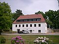 Municipal administration of Spreetal
 -
 War memorial in Burgneudorf, district of Spreetal
 -
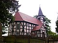 Church in Spreewitz, district of Spreetal
 -
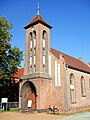 Church in Burghammer, district of Spreetal
 -
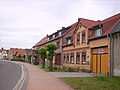 Street in Burg, district of Spreetal


References
- ^ Bürgermeisterwahlen 2017, Freistaat Sachsen, accessed 12 July 2021.
- ^ "Einwohnerzahlen nach Gemeinden als Excel-Arbeitsmappe" (XLS) (in German). Statistisches Landesamt des Freistaates Sachsen. 2024.
- v
- t
- e
Towns and municipalities in Bautzen (district)
- Arnsdorf
- Bautzen/Budyšin
- Bernsdorf
- Bischofswerda
- Burkau/Porchow
- Crostwitz/Chrósćicy
- Cunewalde
- Demitz-Thumitz
- Doberschau-Gaußig/Dobruša-Huska
- Elsterheide/Halštrowska Hola
- Elstra/Halštrow
- Frankenthal
- Göda/Hodźij
- Großdubrau/Wulka Dubrawa
- Großharthau
- Großnaundorf
- Großpostwitz/Budestecy
- Großröhrsdorf
- Haselbachtal
- Hochkirch/Bukecy
- Hoyerswerda/Wojerecy
- Kamenz/Kamjenc
- Königsbrück
- Königswartha/Rakecy
- Kubschütz/Kubšicy
- Laußnitz
- Lauta
- Lichtenberg
- Lohsa/Łaz
- Malschwitz/Malešecy
- Nebelschütz/Njebjelčicy
- Neschwitz/Njeswačidło
- Neukirch/Lausitz
- Neukirch (bei Königsbrück)
- Obergurig/Hornja Hórka
- Ohorn
- Oßling/Wóslink
- Ottendorf-Okrilla
- Panschwitz-Kuckau/Pančicy-Kukow
- Pulsnitz
- Puschwitz/Bóšicy
- Räckelwitz/Worklecy
- Radeberg
- Radibor/Radwor
- Ralbitz-Rosenthal/Ralbicy-Róžant
- Rammenau
- Schirgiswalde-Kirschau
- Schmölln-Putzkau
- Schwepnitz
- Sohland an der Spree
- Spreetal/Sprjewiny Doł
- Steina
- Steinigtwolmsdorf
- Wachau
- Weißenberg/Wóspork
- Wilthen
- Wittichenau/Kulow

Authority control databases | |
|---|---|
| International |
|
| National |
|
| Geographic |
|
 | This Bautzen location article is a stub. You can help Wikipedia by expanding it. |
- v
- t
- e


