Stupferich
District of Karlsruhe
Borough of Karlsruhe in Baden-Württemberg, Germany

Coat of arms
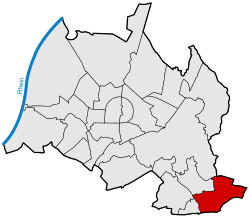
Location of Stupferich within Karlsruhe
48°57′N 8°30′E / 48.950°N 8.500°E / 48.950; 8.500
(2020-12-31)
76228
Stupferich is a district of Karlsruhe. The high-altitude district is one of the Bergdörfer (mountain villages) of Karlsruhe and is located about 100 meters above the city center in the hilly landscape on the southeastern edge of the city area. In terms of natural geography, it belongs to the southern Kraichgau and has been part of the Central/North Black Forest Nature Park since January 2021.
History
The first documented mention as Stutpferrich in a copy of the Codex Hirsaugiensis dates back to the year 1100. The name suggests that the place was originally built for horse breeding.[1]
An alleged castle called Burg Stupferich, which is said to have been located south of the village, can no longer be proven today.[2]
In 1972 Stupferich was incorporated into Karlsruhe.[1]
References
- ^ a b "Geschichte Stupferichs". karlsruhe.de. City of Karlsruhe. Retrieved 16 September 2024.
- ^ Schuster, Eduard (1908). Die Burgen und Schlösser Badens. Karlsruhe: Hofbuchhandlung Friedrich Gutsch. p. 273.
External links
Wikimedia Commons has media related to Stupferich.
- Stupferich on the website of the city of Karlsruhe
- v
- t
- e
Boroughs of Karlsruhe
- Beiertheim-Bulach
- Daxlanden
- Durlach
- Grötzingen
- Grünwettersbach
- Grünwinkel
- Hagsfeld
- Hohenwettersbach
- Innenstadt-Ost
- Innenstadt-West
- Knielingen
- Mühlburg
- Neureut
- Nordstadt
- Nordweststadt
- Oberreut
- Oststadt
- Palmbach
- Rintheim
- Rüppurr
- Stupferich
- Südstadt
- Südweststadt
- Waldstadt
- Weiherfeld-Dammerstock
- Weststadt
- Wolfartsweier
Authority control databases | |
|---|---|
| International |
|
| National |
|


