Sule Stack
2.9 ha (7+1⁄4 acres)

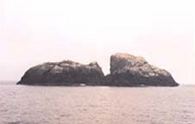
Sule Stack or Stack Skerry is an extremely remote island or stack in the North Atlantic off the north coast of Scotland. It is formed of Lewisian gneiss.[5]
Sule Stack lies 49 kilometres (26+1⁄2 nautical miles) north of the Scottish mainland, and 66 km (35+1⁄2 nmi) west of the Orkney mainland, at grid reference HX561179. Sule Stack's sole neighbour, Sule Skerry, lies 10 km (5+1⁄2 nmi) northeast and the remote islands of Rona and Sula Sgeir lie further to the west. Sule Stack and Sule Skerry are home to thousands of gannets and as a result are listed as a special protection area; the island falls within the administrative region of the Orkney Islands.
The island (along with Skule Skerry) has been designated an Important Bird Area (IBA) by BirdLife International because it supports breeding populations of several species of seabirds.[6]
Bird species nesting on the stack include:[7]
- Razorbill Alca torda
- Atlantic puffin Fratercula arctica
- Fulmar Fulmarus glacialis
- Great black-backed gull Larus marinus
- Common shag Phalacrocorax aristotelis
- Black-legged kittiwake Rissa tridactyla
- Arctic tern Sterna paradisaea
- Northern gannet Morus bassanus
- Common guillemot Uria aalge
See also
References
- ^ Stewart 1938, p. 283.
- ^ National Records of Scotland 2013.
- ^ Haswell-Smith 2004.
- ^ Orkney (Mainland) 2014.
- ^ Kirton & Hitchen 1987.
- ^ "Sule Skerry and Sule Stack". BirdLife Data Zone. BirdLife International. 2024. Retrieved 28 August 2024.
- ^ EEA n.d.
Sources
- Haswell-Smith, Hamish (2004). The Scottish Islands. Edinburgh: Canongate. ISBN 978-1-84195-454-7.
- Kirton, S.R.; Hitchen, K. (1987). "Timing and style of crustal extension N of the Scottish mainland". In Coward, M.P.; Dewey, J.F.; Hancock, P.L. (eds.). Continental Extensional Tectonics. Special Publications. Vol. 28. London: Geological Society. pp. 501–510. ISBN 978-0-632-01605-1.
- National Records of Scotland (15 August 2013). "Appendix 2: Population and households on Scotland's Inhabited Islands" (PDF). Statistical Bulletin: 2011 Census: First Results on Population and Household Estimates for Scotland Release 1C (Part Two) (PDF) (Report). SG/2013/126. Retrieved 14 August 2020.
- Orkney (Mainland) (Map). 1:50,000. Landranger. Ordnance Survey. 2014. ISBN 9780319228128.
- Stewart, Malcolm (1 February 1938), "Notes on the Gannetries of Sule Stack and Sula Sgeir" (PDF), British Birds, 31 (9), Witherby & Co.: 282–294
- "Sule Skerry & Stack Skerry". European Environment Agency.
External links
Wikimedia Commons has media related to Sule Stack.
59°01′26″N 4°30′30″W / 59.02382°N 4.50846°W / 59.02382; -4.50846
- v
- t
- e


