Sunny Hill Park

Sunny Hill Park is a park in Hendon, in the London Borough of Barnet, England. It is a large hilly park, 22 hectares,[1] mainly grassed, which has extensive views to the north and the west. Together with the neighbouring Hendon Churchyard, it is a Site of Local Importance for Nature Conservation.[2][3]
The site used to be Sunnyhill Fields, and was owned by Church Farmhouse, now the adjoining Church Farmhouse Museum. In 1921 Hendon Council purchased 16 acres for a park, which opened in 1922, and in 1929 it was enlarged when further land was acquired.[4] An area with scattered trees in the south-east corner was formerly part of St Mary's Churchyard, an important archaeological site with evidence of Roman and Anglo-Saxon occupation.[5] The park still has hedgerows showing former field boundaries and mature trees.[4]
It has a cafe, a playground, various tennis and basketball courts and football pitches.
There is access from Church End, Sunny Hill, Watford Way, Great North Way, Sunny Gardens Road, Sunningfields Crescent and Church Terrace.
Gallery
-
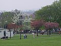 Sunny Hill Park landscape
 -
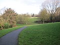 Sunny Hill Park from southern end
 -
 Sunny Hill Park cafe
 -
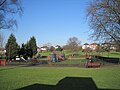 Sunny Hill Park playground
 -
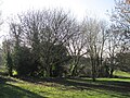 South east corner of Sunny Hill Park
 -
 View north from Sunny Hill Park
 -
 Steps at Sunny Hill Park


See also
External links
- Sunny Hill Park, London Gardens Online
Further reading
- Hewlett, Janet (1997). Nature Conservation in Barnet. London Ecology Unit. ISBN 1 871045 27 4.
Notes
- ^ Mill Hill East Environmental Statement
- ^ "Sunny Hill Park and Hendon Churchyard". Greenspace Information for Greater London. 2006. Archived from the original on 24 December 2012. Retrieved 9 September 2012.
- ^ "iGiGL – helping you find London's parks and wildlife sites". Greenspace Information for Greater London. 2006. Archived from the original on 2012-10-15.
- ^ a b Sunny Hill Park, London Gardens Online. Archived 2016-03-03 at the Wayback Machine
- ^ Roman Hendon - Another Piece of the Jigsaw, Hendon & District Archaeological Society Archived 2012-03-17 at the Wayback Machine
51°35′49″N 0°13′48″W / 51.597°N 0.230°W / 51.597; -0.230
- v
- t
- e
- Arkley Lane and Pastures
- Arkley South Fields
- Arrandene Open Space and Featherstone Hill
- Ashley Lane
- Avenue House Grounds
- Barfield Allotments Nature Park
- Barnet Countryside Centre
- Barnet Gate Wood
- Bell's Hill Burial Ground
- Belmont Open Space
- Big Wood and Little Wood
- Brent Park
- Brent Reservoir (Welsh Harp)
- Bruno's Field
- Burnt Oak Brook
- Burtonhole Lane and Pasture
- Cherry Tree Wood
- Clarefield Park
- Clay Lane
- Clitterhouse Recreation Ground
- College Farm
- Coppett's Wood and Scrublands
- Copthall Railway Walk and Copthall Old Common
- Copthall South Fields
- Darland's Lake
- Deans Brook
- Dollis Brook
- Drivers Hill
- East Finchley Cemetery
- Edgware Way Rough
- Edgwarebury Brook
- Edgwarebury Park
- Folly Brook
- Friary Park
- Glebe Lane Pastures
- Glebelands Local Nature Reserve
- Golders Hill Park
- Greenhill Gardens
- Hadley Green
- Hampstead Heath Extension
- Hendon Churchyard
- Hendon Park and Northern Line Railway Cutting
- King George's Fields
- Lakeside Nature Reserve
- Mill Hill Golf Course
- Mill Hill Old Railway Nature Reserve
- Mill Hill Substation Pastures
- Moat Mount
- Monken Hadley Common
- Mutton Brook
- New Southgate Cemetery
- North Middlesex Golf Course Ponds
- Northern Line Embankment, High Barnet
- Oak Hill Wood
- Oakleigh Park Rail Cutting
- Princes Park
- Pymme's Brook
- River Brent
- Rowley Green Common
- Rowley Lodge Field
- Scratchwood
- Silk Stream
- St Pancras and Islington Cemetery
- Stoneyfields Park
- Sulloniacis Pastures
- Sunny Hill Park
- The Mill Field
- Totteridge Common
- Totteridge Croft Field
- Totteridge Fields
- Totteridge Green
- Turner's Wood
- Woodridge Nature Reserve


