Target Field station
Transit hub in Minneapolis, Minnesota
- 1 island platform (light rail platform 1)
- 2 side platforms (light rail platform 2)
- 1 island platform (Northstar)
- 2 (light rail)
- 3 (Northstar, including bypass track)
 C Line
- D Line
- Metro Transit: 9, 14, 22, 94[1]

At-grade (Northstar)
 29.6% (Metro Transit light rail)
| Preceding station | Following station | |||
|---|---|---|---|---|
| Terminus | Blue Line | Warehouse District/Hennepin Avenue toward Mall of America | ||
| Green Line | Warehouse District/Hennepin Avenue toward Saint Paul Union Depot | |||
| Preceding station | Following station | |||
| Fridley towards Big Lake | Northstar Line | Terminus | ||
Proposed and future service | |||||||||||||||||||||||||||||||||||
|---|---|---|---|---|---|---|---|---|---|---|---|---|---|---|---|---|---|---|---|---|---|---|---|---|---|---|---|---|---|---|---|---|---|---|---|
| |||||||||||||||||||||||||||||||||||
Location | |
|---|---|
 |
Target Field station (formerly known during construction under the names of Minneapolis Intermodal Station, Downtown Minneapolis/Ballpark Station, and The Interchange) is a multimodal commuter train and light rail station in Minneapolis, Minnesota. Located in the North Loop area of Downtown Minneapolis, the station is named for Target Field, the Minnesota Twins baseball stadium. METRO Blue Line light rail service started on November 14, 2009; Northstar Line commuter rail service started November 16, 2009; METRO Green Line light rail service started on June 14, 2014.
Layout

The station adjoins Target Field, and commuter rail trains can wait beside the stadium. The station has an island platform serving commuter rail and two sets of light rail island platforms. The original, Platform 1, opened in 2009 with the extension, Platform 2, opened in 2014.
The lower level Northstar platform runs northeast–southwest at ground level between two tracks. The original light rail platform runs perpendicular over the commuter rail tracks, parallel to the 5th Street North bridge. Platform 2 was built northwest of the Platform 1, approximately 100 feet (30 m) apart. Near the commuter platform is a third track on the northwest side, allowing freight traffic to bypass the platform tracks.
History
The first railroad tracks in Minneapolis on the west bank of the Mississippi were placed in this location by the St. Paul and Pacific Railroad which later became the Great Northern Railway. The Minneapolis and St. Louis Railway and Great Northern Railway laid parallel east/west tracks in this location platted as Dakota Avenue/4th Avenue between 3rd Street North and 5th Street North. The Minneapolis and St. Louis Track was the southern track, and the Great Northern track was the northern track. This grade separation was agreed upon in 1890 after much litigation.[5] The rail bed was lowered to form what is known as "The Cut" below the street grade today.[6]
The station is near the sites of other former Minneapolis railroad depots. The first rail depot in downtown Minneapolis, for the St. Paul and Pacific, was located east near the present-day Fourth Street along the same tracks.[5] The Minneapolis and St. Louis railway freight and passenger depots were located at the East side of Washington Avenue, also east of the present Target Field station.[7] The Electric Short Line Railway (Luce Line) depot was located at the northwest corner of 7th St. North and 3rd Avenue North. It was shared with the Minneapolis, St. Paul, Rochester and Dubuque Electric Traction Company (known as the Dan Patch Line and later the Minneapolis, Northfield and Southern Railway), as well as the Minneapolis, Anoka and Cuyuna Range Interurban railway.[5]
The last passenger rail station to operate in Minneapolis was the Minneapolis Great Northern Depot, which was served by Amtrak until 1978.
2009 station
The station was opened in 2009 to serve Northstar Commuter Rail and the Hiawatha Line, now METRO Blue Line. The light rail line was extended from its existing terminus at Warehouse District / Hennepin Avenue to serve the new station. This was the first time for Minneapolis regaining access to passenger rail for 31 years.
The Minnesota Twins pledged $2.6 million for its construction.[8]
2014 addition
The 2014 addition was designed by New York-based Perkins Eastman, to provide additional platform space for both METRO Green and Blue Lines, as well as provide community gathering space.[9] The additional platform is referred to as Platform 2, while the original platform became Platform 1.
Future plans
The Green Line extension, also known as the Southwest Corridor to Eden Prairie and the Blue Line extension, also known as the Bottineau Boulevard to Brooklyn Park will serve Target Field. The Northern Lights Express to Duluth would originate at Target Field.
Potential regional rail routes from Target Field station include the Dakota Rail Corridor to Hutchinson, the Dan Patch Corridor to Northfield, the Little Crow Line to Willmar, the Red Rock Corridor to Hastings, and the Minnesota Prairie Line to Norwood Young America.
Operation
Light rail trains serve both Platforms 1 and 2. Each train stops twice at the station to serve each platform.
The Northstar Line one-way fares from this station range from $1.00 to $3.25 on weekdays and $1.00 to $2.75 on weekends, depending on the destination.[10] The Northstar Line provides five morning and five afternoon trips each weekday.[11]
Recognition
Target Field Station won a 2015 Institute Honor Award for Regional and Urban Design by the American Institute of Architects.[9]
Additional photos
-
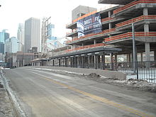
 View of the commuter platform in front of the nearly-complete Target Field. The upper light-rail platforms are obscured by bridges.
 -
 First pair of light rail platforms, June 2009. Note the "Downtown Minneapolis/Ballpark" platform signage
 -
 Northstar platform, June 2009


References
- ^ "Twin Cities Metropolitan Area Transit System" (PDF) (Map). Metro Transit. August 19, 2023. Retrieved November 10, 2023.
- ^ "Minnesota's New Star to begin service Nov. 16 – Metropolitan Council news release". Archived from the original on 2009-11-19. Retrieved 2015-04-23.
- ^ "Home". theinterchange.net.
- ^ "Transit Stops Boardings and Alightings - Minnesota Geospatial Commons". gisdata.mn.gov. Retrieved 2024-06-17.
- ^ a b c Hofsommer, Don L. (2005). Minneapolis and the Age of Railways: And the Age of Railways. University of Minnesota Press. ISBN 0-8166-4501-9.
- ^ Minneapolis Warehouse District Designation Study. City of Minneapolis, Planning commission. October 2009
- ^ Donovan L. Hofsommer (2009). The Minneapolis & St. Louis Railway: A Photographic History. U of Minnesota Press. ISBN 978-0-8166-5131-3.
- ^ Paul Levy and Joy Powell, Finally, all aboard Northstar rail, Star Tribune, December 10, 2007.
- ^ a b Leigh Painter, Kristen (10 January 2015). "Target Field Station wins national design award". Star Tribune. Retrieved 15 March 2015.
- ^ "Fares – Metro Transit".
- ^ "Target Field Station". Metro Transit. Retrieved April 2, 2020.
External links
 Media related to Target Field (Metro Transit station) at Wikimedia Commons
- Metro Transit – Target Field Station
- Downtown Minneapolis Ballpark Station, Northstar Corridor Development Authority (NCDA)
- v
- t
- e
Minnesota Metro stations

- Target Field
- Warehouse District/Hennepin Avenue
- Nicollet Mall
- Government Plaza
- U.S. Bank Stadium
- Cedar–Riverside
- Franklin Avenue
- Lake Street/Midtown
- 38th Street
- 46th Street
- 50th Street/Minnehaha Park
- VA Medical Center
- Fort Snelling
- Terminal 1–Lindbergh
- Terminal 2–Humphrey
- American Boulevard
- Bloomington Central
- 30th Avenue
- Mall of America
- Target Field
- Warehouse District/Hennepin Avenue
- Nicollet Mall
- Government Plaza
- U.S. Bank Stadium
- West Bank
- East Bank
- Stadium Village
- Prospect Park
- Westgate
- Raymond Avenue
- Fairview Avenue
- Snelling Avenue
- Hamline Avenue
- Lexington Parkway
- Victoria Street
- Dale Street
- Western Avenue
- Capitol/Rice Street
- Robert Street
- 10th Street
- Central
- Union Depot

- Marquette-2nd Avenue & 3rd Street-Washington
- Marquette-2nd Avenue & 5th Street
- Marquette-2nd Avenue & 7th Street
- Marquette-2nd Avenue & 11th Street
- I-35W & Lake Street
- I-35W & 46th Street
- I-35W & 66th Street
- Knox & 76th Street
- Knox & American Boulevard
- I-35W & 98th Street station
- I-35W & Burnsville Parkway
- Burnsville Heart of the City
- Mall of America
- Cedar Grove
- 140th Street
- 147th Street
- Apple Valley Transit Center
- 46th Street
- 46th Street & Minnehaha
- 46th Street & 46th Avenue
- Ford & Woodlawn
- Ford & Finn
- Ford & Kenneth
- Ford & Fairview
- Snelling & Highland
- Snelling & Randolph
- Snelling & St. Clair
- Snelling & Grand
- Snelling & Dayton
- Snelling & University
- Snelling & Minnehaha
- Snelling & Hewitt
- Snelling & Como
- Snelling & Hoyt-Nebraska
- Snelling & Larpenteur
- Snelling & County Road B
- Rosedale Transit Center
- Brooklyn Center Transit Center
- Xerxes & 56th Avenue
- Brooklyn & 51st Avenue
- Penn & 43rd Avenue
- Penn & Dowling
- Penn & 36th Avenue
- Penn & Lowry
- Penn & 29th Avenue
- Penn & West Broadway
- Penn & Golden Valley
- Penn & Plymouth
- Olson & Penn
- Olson & Humboldt
- Olson & Bryant
- 7th Street & Olson/5th Avenue
- Ramp A/7th Street Transit Center
- 7th Street & Hennepin
- 7th-8th Street & Nicollet
- 7th-8th Street & 3rd/4th Avenue
- 7th-8th Street & Park
- Brooklyn Center Transit Center
- Xerxes & 56th Ave
- Brooklyn & 51st Ave
- 44th Ave & Penn
- 44th Ave & Girard
- Fremont & 42nd Ave
- Fremont & Dowling
- Fremont & 35th Ave
- Fremont/Emerson & Lowry
- Fremont/Emerson & 26th Ave
- Fremont/Emerson & West Broadway
- Fremont/Emerson & Plymouth
- 7th St & Bryant
- 7th St & Olson/5th Ave
- Ramp A/7th St Transit Center (southbound)
- 7th/8th St & Hennepin
- 7th/8th St & Nicollet
- 7th/8th St & 3rd/4th Ave
- 7th/8th St & Park
- Chicago & 14th St
- Chicago & Franklin
- Chicago & 24th St
- Chicago & 26th St
- Chicago-Lake Transit Center
- Chicago & 34th St
- Park-Portland & 38th St
- Chicago & 42nd St
- Chicago & 46th St
- Chicago & 48th St
- Chicago & 52nd St
- Chicago & 56th St
- Portland & 60th St
- Portland & 66th St
- Portland & 70th St
- Portland & 73rd St
- Portland & 77th St
- American & Chicago
- American & Bloomington
- American & Thunderbird
- Mall of America


