Temotufoliki
Islet in Nanumea atoll, Tuvalu
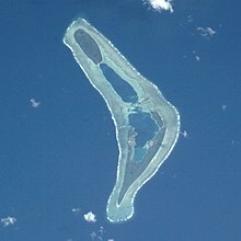
Te Motu Foliki is an islet of Nanumea atoll, Tuvalu.[1][2] It is a small uninhabited islet, which Nanumean traditions describe as being formed when sand spilled from the baskets of two women, Pai and Vau, when they were forced off Nanumea by Tefolaha, the Tongan warrior who became the ancestor of the people of Nanumea.[3]
See also
 Islands portal

- Desert island
- List of islands
References
- ^ Map of Nanumea. Tuvaluislands.com.
- ^ British Admiralty Nautical Chart 766 Ellice Islands (1893 ed.). United Kingdom Hydrographic Office (UKHO). 21 March 1872.
- ^ Isako, Taulu (1983). "Chapter 7 – Nanumea". In Laracy, Hugh (ed.). Tuvalu: A History. Institute of Pacific Studies, University of the South Pacific and Government of Tuvalu. p. 49.
- v
- t
- e
Islands and atolls of Tuvalu
- Nanumanga
- Niulakita
- Niutao

- Funafuti
- Nanumea
- Nui
- Nukufetau
- Nukulaelae
- Vaitupu
- Amatuku
- Avalau
- Falaoigo
- Fale Fatu
- Fatato
- Fongafale
- Fuafatu
- Fuagea
- Fualefeke
- Fualopa
- Funafala
- Funamanu
- Luamotu
- Mateika
- Motugie
- Motuloa
- Mulitefala
- Nukusavalevale
- Papa Elise
- Te Afuafou
- Te Afualiku
- Tefala
- Telele
- Tengasu
- Tepuka
- Tepuka Vili Vili
- Tutanga
- Vasafua
- Lakena
- Lefogaki
- Teatua a Taepoa
- Temotufoliki
- Faiava Lasi
- Fale
- Funaota
- Kongo Loto Lafanga
- Lafanga
- Matanukulaelae
- Motufetau
- Motulalo
- Motuloa (north of Nukufetau)
- Motuloa (south of Nukufetau)
- Motumua
- Niualuka
- Niuatui
- Oua
- Sakalua
- Savave
- Teafatule
- Teafuaniua
- Teafuanonu
- Teafuone
- Temotuloto
 Tuvalu portal
5°39′38.20″S 176°06′52.55″E / 5.6606111°S 176.1145972°E / -5.6606111; 176.1145972
 | This Tuvalu location article is a stub. You can help Wikipedia by expanding it. |
- v
- t
- e


