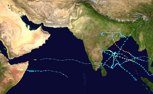
The 2013 North Indian Ocean cyclone season was an average season during the period of tropical cyclone formation in the North Indian Ocean.[a] The season began in May with the formation of Cyclone Viyaru, which made landfall on Bangladesh, destroying more than 26,500 houses.[b][2] After a period of inactivity, Cyclone Phailin formed in October, and became an extremely severe cyclonic storm. Additionally, it was a Category 5-equivalent cyclone on the Saffir–Simpson hurricane wind scale. It then made landfall in the Indian states of Andhra Pradesh and Odisha, becoming the most intense cyclone to strike the country since the 1999 Odisha cyclone.[3] In November, cyclones Helen and Lehar formed, and they both made landfall in Andhra Pradesh just one week away from each other.[4] The latter also affected the Andaman and Nicobar Islands.[4]
This timeline documents all the events of this season, including the strengthening, weakening, formation, dissipation, and landfall of tropical cyclones in both the Bay of Bengal and the Arabian Sea. When depressions form in the Bay of Bengal, they receive the prefix BOB by the India Meteorological Department (IMD). Likewise, depressions which form in the Arabian Sea are designated the prefix ARB, and those which form over land are given the prefix LAND. The Joint Typhoon Warning Center (JTWC) also creates advisories on storms in the North Indian Ocean. It designates the prefix B for storms that form in the Bay of Bengal, and the prefix A for those which form in the Arabian Sea. Best track data from the IMD and JTWC is utilized in this article, which means that post-storm analyses take precedence over operational advisories and the like. Meteorologists use one time zone, Coordinated Universal Time (UTC), when issuing forecasts and advisories.[5] As such, the time of the events in this season are listed in UTC as well as the local time, which is, in this case, Indian Standard Time (IST).
Timeline of events
May
10 May
00:00 UTC (5:30 a.m. IST) at 4°24′N93°00′E / 4.4°N 93.0°E / 4.4; 93.0 (The JTWC reports that Tropical Depression 01B has formed) – The JTWC reports that Tropical Depression 01B has formed.[6]
06:00 UTC (11:30 a.m. IST) at 4°54′N93°00′E / 4.9°N 93.0°E / 4.9; 93.0 (The JTWC reports that Tropical Depression 01B has intensified into a tropical storm) – The JTWC reports that Tropical Depression 01B has intensified into a tropical storm.[6]
09:00 UTC (2:30 p.m. IST) at 5°00′N92°00′E / 5.0°N 92.0°E / 5.0; 92.0 (The IMD reports that Depression BOB 01 has formed) – The IMD reports that Depression BOB 01 has formed.[7]
12:00 UTC (5:30 p.m. IST) at 5°30′N92°00′E / 5.5°N 92.0°E / 5.5; 92.0 (Depression BOB 01 intensifies into a deep depression) – The IMD reports that Depression BOB 01 has intensified into a deep depression.[7]
11 May
03:00 UTC (8:30 a.m. IST) at 7°00′N90°30′E / 7.0°N 90.5°E / 7.0; 90.5 (Deep Depression BOB 01 strengthens into Cyclonic Storm Viyaru) – The IMD reports that Deep Depression BOB 01 has strengthened into Cyclonic Storm Viyaru.[7]
06:00 UTC (11:30 a.m. IST) at 8°00′N89°48′E / 8.0°N 89.8°E / 8.0; 89.8 (The JTWC reports that Tropical Storm 01A has reached its peak intensity) – The JTWC reports that Tropical Storm 01A has reached its peak intensity with wind speeds of 85 km/h (55 mph) and a minimum pressure of 989 mbar (29.21 inHg).[6]
15 May
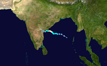
Track of Cyclone Viyaru, according to the Saffir–Simpson wind scale06:00 UTC (11:30 a.m. IST) at 17°00′N87°30′E / 17.0°N 87.5°E / 17.0; 87.5 (Cyclonic Storm Viyaru reaches its peak intensity) – The IMD reports that Cyclonic Storm Viyaru has reached its peak intensity, with wind speeds of 85 km/h (55 mph) and a minimum pressure of 990 mbar (29.23 inHg).[7]
16 May
08:00 UTC (1:30 p.m. IST) at 22°48′N91°24′E / 22.8°N 91.4°E / 22.8; 91.4 (Cyclonic Storm Viyaru makes landfall on the Bangladesh coast) – The IMD reports that Cyclonic Storm Viyaru has made landfall on the Bangladesh coast about 30 km (20 mi) south of Feni.[7]
12:00 UTC (5:30 p.m. IST) at 24°00′N92°30′E / 24.0°N 92.5°E / 24.0; 92.5 (Cyclonic Storm Viyaru weakens to a deep depression) – The IMD reports that Cyclonic Storm Viyaru has weakened to a deep depression.[7]
18:00 UTC (11:30 p.m. IST) at 25°00′N93°30′E / 25.0°N 93.5°E / 25.0; 93.5 (Deep Depression Viyaru weakens to a depression) – The IMD reports that Deep Depression Viyaru has degenerated into a depression.[7]
17 May
00:00 (5:30 a.m. IST) – The IMD reports that Depression Viyaru has weakened to a well-marked low pressure area over Nagaland.[7]
29 May
03:00 UTC (8:30 a.m. IST) at 21°00′N89°30′E / 21.0°N 89.5°E / 21.0; 89.5 (Depression BOB 02 forms) – The IMD reports that Depression BOB 02 has formed and simultaneously reached its peak wind speeds of 45 km/h (30 mph).[8]
13:30–14:30 UTC (7:00–8:00 IST) at 21°48′N88°42′E / 21.8°N 88.7°E / 21.8; 88.7 (Depression BOB 02 crosses the West Bengal coast) – The IMD reports that Depression BOB 02 has crossed the West Bengal coast.[8]
30 May
03:00 UTC (8:30 a.m. IST) at 22°18′N87°30′E / 22.3°N 87.5°E / 22.3; 87.5 (Depression BOB 02 reaches its minimum pressure) – The IMD reports that Depression BOB 02 has reached its minimum pressure of 990 mbar (29.23 inHg).[8]
31 May
Depression BOB 02 on May 2912:00 UTC (5:30 p.m. IST) – The IMD reports that Depression BOB 02 has degenerated into a well-marked low pressure area over Bihar and Jharkhand.
July
30 July
03:00 UTC (8:30 a.m. IST) at 21°00′N88°00′E / 21.0°N 88.0°E / 21.0; 88.0 (Depression BOB 03 forms) – The IMD reports that Depression BOB 03 has formed and simultaneously reached its peak intensity with winds of 45 km/h (30 mph) and a minimum pressure of 990 mbar (29.23 inHg).[9]
07:00 UTC (12:30 p.m. IST) – The IMD reports that Depression BOB 03 has crossed the North Odisha and the West Bengal coast between Balasore and Digha.
August
1 August
03:00 UTC (8:30 a.m. IST) – The IMD reports that Depression BOB 03 has weakened into a well-marked low pressure area over southeast Madhya Pradesh and neighboring Chhattisgarh and Vidarbha.[9]
20 August
03:00 UTC (8:30 a.m. IST) at 22°00′N87°30′E / 22.0°N 87.5°E / 22.0; 87.5 (Depression LAND 01 forms) – The IMD reports that Depression LAND 01 has formed and also reached its peak intensity with winds of 45 km/h (30 mph) and a minimum pressure of 990 mbar (29.23 inHg).[10]
23 August
03:00 UTC (8:30 a.m. IST) – The IMD reports that Depression LAND 01 has become a well-marked low-pressure area over the central area of south Madhya Pradesh and Vidarbha.[10]
October
7 October
18:00 UTC (11:30 p.m. IST) at 12°06′N96°24′E / 12.1°N 96.4°E / 12.1; 96.4 (Tropical Depression 02B forms) – The JTWC reports that a tropical depression has formed in the Bay of Bengal.[6]
8 October
03:00 UTC (8:30 a.m. IST) at 12°00′N96°00′E / 12.0°N 96.0°E / 12.0; 96.0 (Depression BOB 04 forms) – The IMD reports that Depression BOB 04 has formed.[3]
9 October
00:00 UTC (5:30 a.m. IST) at 13°00′N93°30′E / 13.0°N 93.5°E / 13.0; 93.5 (Depression BOB 04 strengthens into a deep depression) – The IMD reports that Depression BOB 04 has strengthened into a deep depression.[3]
12:00 UTC (5:30 p.m. IST) at 13°30′N92°30′E / 13.5°N 92.5°E / 13.5; 92.5 (Deep Depression BOB 04 intensifies into a cyclonic storm) – The IMD reports that Deep Depression BOB 04 has strengthened into a cyclonic storm and is subsequently named Phailin.[3]
10 October
03:00 UTC (8:30 a.m. IST) at 14°30′N91°00′E / 14.5°N 91.0°E / 14.5; 91.0 (Cyclonic Storm Phailin becomes a severe cyclonic storm) – The IMD reports that Cyclonic Storm Phailin has become a severe cyclonic storm.[3]
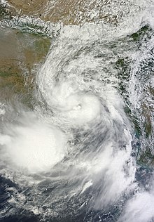
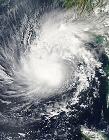
Cyclone Phailin on October 1006:00 UTC (11:30 a.m. IST) at 15°00′N90°30′E / 15.0°N 90.5°E / 15.0; 90.5 (Severe Cyclonic Storm Phailin becomes a Very Severe Cyclonic Storm) – The IMD reports that Severe Cyclonic Storm Phailin has rapidly intensified into a very severe cyclonic storm.[3]
15:00 UTC (8:30 a.m. IST) at 15°30′N90°00′E / 15.5°N 90.0°E / 15.5; 90.0 (Very Severe Cyclonic Storm Phailin rapidly intensifies into an extremely severe cyclonic storm) – The IMD reports that Very Severe Cyclonic Storm Phailin has quickly strengthened into an extremely severe cyclonic storm.[3]
11 October
03:00 UTC (8:30 a.m. IST) at 16°00′N88°30′E / 16.0°N 88.5°E / 16.0; 88.5 (Very Severe Cyclonic Storm Phailin reaches its peak intensity) – The IMD reports that Extremely Severe Cyclonic Storm Phailin has reached its peak intensity with winds of 215 km/h (135 mph) and a minimum pressure of 940 mbar (27.76 inHg).[3]
12 October
17:00 UTC (10:30 p.m. IST) at 19°12′N84°54′E / 19.2°N 84.9°E / 19.2; 84.9 (Very Severe Cyclonic Storm Phailin makes landfall) – The IMD reports that Extremely Severe Cyclonic Storm Phailin has made landfall over Odisha and the north Andhra Pradesh coast.[3]
13 October
00:00 UTC (5:30 a.m. IST) at 20°30′N84°30′E / 20.5°N 84.5°E / 20.5; 84.5 (Extremely Severe Cyclonic Storm Phailin weakens to a very severe cyclonic storm) – The IMD reports that Extremely Severe Cyclonic Storm Phailin has weakened to a very severe cyclonic storm.
03:00 UTC (8:30 a.m. IST) at 21°00′N84°00′E / 21.0°N 84.0°E / 21.0; 84.0 (Very Severe Cyclonic Storm Phailin weakens to a severe cyclonic storm) – The IMD reports that Very Severe Cyclonic Storm Phailin has weakened to a severe cyclonic storm.[3]
06:00 UTC (11:30 a.m. IST) at 21°30′N84°00′E / 21.5°N 84.0°E / 21.5; 84.0 (Severe Cyclonic Storm Phailin weakens to a cyclonic storm) – The IMD reports that Severe Cyclonic Storm Phailin has weakened to a cyclonic storm.[3]
18:00 UTC (11:30 p.m. IST) at 23°00′N83°30′E / 23.0°N 83.5°E / 23.0; 83.5 (Cyclonic Storm Phailin degenerates into a deep depression) – The IMD reports that Cyclonic Storm Phailin has degenerated into a deep depression.[3]
14 October
03:00 UTC (8:30 a.m. IST) at 24°00′N84°06′E / 24.0°N 84.1°E / 24.0; 84.1 – The IMD reports that Deep Depression Phailin has degenerated into a depression.[3]
09:00 UTC (2:30 p.m. IST) – The IMD reports that Depression Phailin has weakened to a well-marked low pressure area over southwest Bihar and the areas surrounding it.[3]
November
8 November
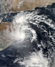
Deep Depression ARB 01 near the coast of Somalia on November 1006:00 UTC (11:30 a.m. IST) at 8°00′N86°30′E / 8.0°N 86.5°E / 8.0; 86.5 (Depression ARB 01 forms) – The IMD reports that Depression ARB 01 has formed.[11]
9 November
00:00 UTC(5:30 a.m. IST) at 8°00′N53°00′E / 8.0°N 53.0°E / 8.0; 53.0 (Depression ARB 03 becomes a deep depression) – The IMD reports that Depression ARB 01 has intensified into a deep depression and simultaneously reaches its peak intensity with wind speeds of 55 km/h (35 mph) and a peak intensity of 1,002 mbar (29.59 inHg).[11]
10 November
23:00–00:00 UTC (4:30–5:30 a.m. IST 11 November) at 8°12′N50°06′E / 8.2°N 50.1°E / 8.2; 50.1 (Deep Depression ARB 01 crosses the coast of Somalia) – The IMD reports tha tDeep Depression ARB 01 has made landfall on the coast of Somalia.[11]
11 November
06:00 UTC (11:30 a.m. IST) at 8°42′N49°18′E / 8.7°N 49.3°E / 8.7; 49.3 (Deep Depression ARB 01 weakens to a depression) – The IMD reports that Deep Depression ARB 01 has weakened to a depression.[11]
12:00 UTC (5:30 p.m. IST) – The IMD reports that Depression ARB 01 has weakened to a well-marked low pressure area over Somalia.[11]
13 November
00:00 UTC (5:30 a.m. IST) at 11°30′N86°30′E / 11.5°N 86.5°E / 11.5; 86.5 (Depression BOB 05 forms) – The IMD reports that Depression BOB 05 has formed.[12]
12:00 UTC (5:30 p.m. IST) at 11°30′N86°00′E / 11.5°N 86.0°E / 11.5; 86.0 (Depression BOB 03 reaches its peak intensity) – The IMD reports that Depression BOB 05 has reached its peak intensity with winds of 45 km/h (30 mph) and a minimum pressure of 1,003 mbar (29.62 inHg).[12]
16 November
07:30 UTC (1:00 p.m. IST) – The IMD reports that Depression BOB 05 has made landfall on the Tamil Nadu coast near Nagapattinam.[12]
17 November
00:00 UTC (5:30 a.m. IST) – The IMD reports that Depression BOB 05 has weakened to a well-marked low pressure area over northern Tamil Nadu and the areas surrounding it.[12]
19 November
00:00 UTC (5:30 a.m. IST) at 14°30′N86°30′E / 14.5°N 86.5°E / 14.5; 86.5 (Depression BOB 06 forms) – The IMD reports that Depression BOB 06 has formed.[13]
15:00 UTC (8:30 p.m. IST) at 15°00′N85°00′E / 15.0°N 85.0°E / 15.0; 85.0 (Depression BOB 06 intensifies into a deep depression) – The IMD reports that Depression BOB 06 has intensified into a deep depression.[13]
20 November
03:00 UTC (8:30 a.m. IST) at 15°00′N84°00′E / 15.0°N 84.0°E / 15.0; 84.0 (Deep Depression BOB 06 strengthens into a cyclonic storm) – The IMD reports that Deep Depression BOB 06 has strengthened into a cyclonic storm, receiving the name Helen from the IMD.[13]
21 November
Track of Cyclone Helen according to the Saffir–Simpson wind scale00:00 UTC (5:30 a.m. IST) at 15°36′N83°30′E / 15.6°N 83.5°E / 15.6; 83.5 (Cyclonic Storm Helen intensifies into a severe cyclonic storm) – The IMD reports that Cyclonic Storm Helen has intensified into a severe cyclonic storm.[13]
06:00 UTC (11:30 a.m. IST) at 15°54′N83°18′E / 15.9°N 83.3°E / 15.9; 83.3 (Severe Cyclonic Storm Helen reaches its peak intensity) – The IMD reports that Severe Cyclonic Storm Helen has reached its peak intensity with winds of 100 km/h (60 mph) and a minimum pressure of 990 mbar (29.23 inHg).[13]
22 November
08:00–09:00 UTC (1:30–2:30 p.m. IST) at 16°06′N81°12′E / 16.1°N 81.2°E / 16.1; 81.2 (Severe Cyclonic Storm Helen makes landfall) – The IMD reports that Severe Cyclonic Storm Helen has made landfall on the Andhra Pradesh coast in south Machilliptnam.[13]
09:00 UTC (2:30 p.m. IST) at 16°06′N81°12′E / 16.1°N 81.2°E / 16.1; 81.2 (Severe Cyclonic Storm Helen weakens to a cyclonic storm) – The IMD reports that Severe Cyclonic Storm Helen has weakened to a cyclonic storm.[13]
12:00 UTC (5:30 p.m. IST) at 15°54′N80°42′E / 15.9°N 80.7°E / 15.9; 80.7 (Cyclonic Storm Helen weakens to a deep depression) – The IMD reports that Cyclonic Storm Helen has weakened to a deep depression.[13]
18:00 UTC (11:30 p.m. IST) at 15°54′N80°24′E / 15.9°N 80.4°E / 15.9; 80.4 (Deep Depression Helen weakens to a depression) – The IMD reports that Deep Depression Helen has weakened to a depression.[13]
23 November
00:00 UTC (5:30 a.m. IST) – The IMD reports that Depression Helen has degenerated to a well-marked low pressure area over coastal Andhra Pradesh and the areas surrounding it.[13]
12:00 UTC (5:30 p.m. IST) at 8°30′N96°30′E / 8.5°N 96.5°E / 8.5; 96.5 (Depression BOB 07 forms) – The IMD reports that Depression BOB 07 has formed.[14]
18:00 UTC (11:30 p.m. IST) at 9°00′N96°00′E / 9.0°N 96.0°E / 9.0; 96.0 (Depression BOB 07 strengthens into a deep depression) – The IMD reports that Depression BOB 07 has rapidly strengthened into a deep depression.[14]
24 November
Cyclone Lehar on November 2500:00 UTC (5:30 a.m. IST) at 10°00′N95°00′E / 10.0°N 95.0°E / 10.0; 95.0 (Deep Depression BOB 07 intensifies into a cyclonic storm) – The IMD reports that Deep Depression BOB 07 has rapidly intensified into a cyclonic storm. It is named Lehar by the IMD.[14]
25 November
00:00 UTC (5:30 a.m. IST) at 12°00′N92°30′E / 12.0°N 92.5°E / 12.0; 92.5 (Cyclonic Storm Lehar makes landfall and becomes a severe cyclonic storm) – The IMD reports that Cyclonic Storm Lehar has made landfall on the Andaman and Nicobar Islands south of Port Blair, and simultaneously becomes a severe cyclonic storm.[14]
21:00 UTC (2:30 a.m. IST 26 November) at 12°30′N91°00′E / 12.5°N 91.0°E / 12.5; 91.0 (Severe Cyclonic Storm Lehar intensifies into a very severe cyclonic storm) – The IMD reports that Severe Cyclonic Storm Lehar has become a very severe cyclonic storm.[14]
26 November
18:00 UTC (11:30 p.m. IST) at 13°06′N88°00′E / 13.1°N 88.0°E / 13.1; 88.0 (Very Severe Cyclonic Storm Lehar reaches its peak intensity) – The IMD reports that Very Severe Cyclonic Storm Lehar has reached its peak intensity with winds of 140 km/h (85 mph) and a minimum pressure of 980 mbar (28.94 inHg).[14]
27 November
12:00 UTC (5:30 p.m. IST) at 14°30′N85°00′E / 14.5°N 85.0°E / 14.5; 85.0 (Very Severe Cyclonic Storm Lehar weakens to a severe cyclonic storm) – The IMD reports that Very Severe Cyclonic Storm Lehar has weakened to a severe cyclonic storm.[14]
18:00 UTC (11:30 p.m. IST) at 15°00′N84°00′E / 15.0°N 84.0°E / 15.0; 84.0 (Severe Cyclonic Storm Lehar degenerates to a cyclonic storm) – The IMD reports that Severe Cyclonic Storm Lehar has weakened to a cyclonic storm.[14]
28 November
00:00 UTC (5:30 a.m. IST) at 15°30′N82°00′E / 15.5°N 82.0°E / 15.5; 82.0 (Cyclonic Storm Lehar weakens to a deep depression) – The IMD reports that Cyclonic Storm Lehar has weakened to a deep depression.[14]
08:30 UTC (2:00 p.m. IST) at 15°54′N81°06′E / 15.9°N 81.1°E / 15.9; 81.1 (Deep Depression Lehar makes landfall on Andhra Pradesh) – The IMD reports that Deep Depression Lehar has made landfall on Andhra Pradesh close to Machilipatnam.[14]
09:00 UTC (2:30 p.m. IST) at 15°54′N81°00′E / 15.9°N 81.0°E / 15.9; 81.0 (Deep Depression Lehar weakens to a depression) – The IMD reports that Deep Depression Lehar has weakened to a depression.[14]
18:00 UTC (11:30 p.m. IST) – The IMD reports that Depression Lehar has weakened to a well-marked low-pressure area over coastal Andhra Pradesh and adjoining Telangana.[14]
December
6 December
03:00 UTC (8:30 a.m. IST) at 10°00′N84°00′E / 10.0°N 84.0°E / 10.0; 84.0 (Depression BOB 08 forms) – The IMD reports that Depression BOB 08 has formed.[15]
18:00 UTC (11:30 p.m. IST) at 10°24′N84°00′E / 10.4°N 84.0°E / 10.4; 84.0 (Depression BOB 08 intensifies into a deep depression) – The IMD reports that Depression BOB 08 has intensified into a deep depression.[15]
7 December
00:00 UTC (5:30 a.m. IST) at 10°30′N84°06′E / 10.5°N 84.1°E / 10.5; 84.1 (Deep Depression BOB 08 intensifies into a cyclonic storm) – The IMD reports that Deep Depression BOB 08 has rapidly intensified into a cyclonic storm, receiving the name Madi from the IMD.[15]
Cyclone Madi on December 709:00 UTC (2:30 p.m. IST) at 10°48′N84°18′E / 10.8°N 84.3°E / 10.8; 84.3 (Cyclonic Storm Madi strengthens into a severe cyclonic storm) – The IMD reports that Cyclonic Storm Madi has strengthened into a severe cyclonic storm.[15]
8 December
06:00 UTC (11:30 a.m. IST) at 12°18′N84°42′E / 12.3°N 84.7°E / 12.3; 84.7 (Severe Cyclonic Storm Madi intensifies into a very severe cyclonic storm) – The IMD reports that Severe Cyclonic Storm Madi has intensified into a very severe cyclonic storm and simultaneously reaches its peak intensity with winds of 120 km/h (75 mph) and a minimum pressure of 986 mbar (29.12 inHg).[15]
9 December
12:00 UTC (5:30 p.m. IST) at 14°36′N84°42′E / 14.6°N 84.7°E / 14.6; 84.7 (Very Severe Cyclonic Storm Madi weakens to a severe cyclonic storm) – The IMD reports that Very Severe Cyclonic Storm Madi has weakened to a severe cyclonic storm.[15]
10 December
03:00 UTC (8:30 a.m. IST) at 15°18′N85°18′E / 15.3°N 85.3°E / 15.3; 85.3 (Severe Cyclonic Storm Madi re-intensifies into a very severe cyclonic storm) – The IMD reports that Severe Cyclonic Storm Madi has re-intensified into a very severe cyclonic storm.[15]
12:00 UTC (5:30 p.m. IST) at 15°24′N85°00′E / 15.4°N 85.0°E / 15.4; 85.0 (Very Severe Cyclonic Storm Madi weakens back into a severe cyclonic storm) – The IMD reports that Very Severe Cyclonic Storm Madi has weakened back into a severe cyclonic storm.[15]
21:00 UTC (2:30 a.m. IST 11 December) at 14°36′N84°36′E / 14.6°N 84.6°E / 14.6; 84.6 (Severe Cyclonic Storm Madi weakens to a cyclonic storm) – The IMD reports that Severe Cyclonic Storm Madi has weakened to a cyclonic storm.[15]
11 December
03:00 UTC (8:30 a.m. IST) at 14°00′N83°48′E / 14.0°N 83.8°E / 14.0; 83.8 (Cyclonic Storm Madi weakens to a deep depression) – The IMD reports that Cyclonic Storm Madi has degenerated to a deep depression.[15]
18:00 UTC (11:30 p.m. IST) at 12°54′N82°42′E / 12.9°N 82.7°E / 12.9; 82.7 (Deep Depression Madi weakens to a depression) – The IMD reports that Deep Depression Madi has weakened to a depression.[15]
12 December
13:30 UTC (7:00 p.m. IST) – The IMD reports that Depression Madi has made landfall on the Tamil Nadu coast near Vedaranyam. It later crossed back into the Palk Strait.[15]
17:00 UTC (10:30 p.m. IST) – The IMD reports that Depression Madi has made landfall on the Tamil Nadu coast again near Tondi.[15]
13 December
00:00 UTC (5:30 a.m. IST) – The IMD reports that Depression Madi has weakened to a well-marked low pressure area over the southeast Arabian Sea near the Kerala coast.[15]
^The India Meteorological Department (IMD) defines an average North Indian Ocean cyclone season to include about 4-6 named storms.[1]
^Cyclone Viyaru was operationally known as Mahasen.
References
^"Tropical Cyclones". India Meteorological Department. Archived from the original on 2009-05-29. Retrieved March 31, 2021.
^"Tropical Cyclone Mahasen - May 2013". ReliefWeb. Retrieved 2021-05-06.
^ abcdefghijklmnVery Severe Cyclonic Storm, PHAILIN over the Bay of Bengal (PDF) (Report). New Delhi, India: India Meteorological Department. October 2013. Archived (PDF) from the original on April 2, 2021. Retrieved March 28, 2021.
^ ab"A week after Helen,Andhra braces for 'very severe cyclonic storm' Lehar". The Indian Express. 2013-11-26. Retrieved 2021-04-07.
^"Understanding the Date/Time Stamps". Miami, Florida: NOAANational Hurricane Center. Archived from the original on July 10, 2020. Retrieved July 10, 2020.
^ abcd"Zip file of all 2013 Indian Ocean Best Tracks and storm/year notes". Joint Typhoon Warning Center. Retrieved April 7, 2021.
^ abcdefghA Preliminary Report, on Cyclonic storm, Viyaru over Bay of Bengal (PDF) (Report). New Delhi, India: India Meteorological Department. May 2013. Retrieved March 24, 2021.
^ abcA Preliminary Report on Depression over Bay of Bengal (PDF) (Report). New Delhi, India: India Meteorological Department. June 2013. Archived (PDF) from the original on April 2, 2021. Retrieved March 25, 2021.
^ abA Preliminary Report on Depression over Bay of Bengal (PDF) (Report). New Delhi, India: India Meteorological Department. August 2013. Archived (PDF) from the original on April 2, 2021. Retrieved March 26, 2021.
^ abA Preliminary Report on Land Depression (PDF) (Report). New Delhi, India: India Meteorological Department. August 2013. Archived (PDF) from the original on April 2, 2021. Retrieved March 27, 2021.
^ abcdeA Preliminary Report on Deep Depression over Arabian Sea (PDF) (Report). New Delhi, India: India Meteorological Department. November 2013. Archived (PDF) from the original on April 2, 2021. Retrieved March 28, 2021.
^ abcdA Preliminary Report on Depression over Bay of Bengal (PDF) (Report). New Delhi, India: India Meteorological Department. December 2013. Archived (PDF) from the original on April 2, 2021. Retrieved March 29, 2021.
^ abcdefghijA Preliminary Report on Severe Cyclonic Storm 'Helen' over the Bay of Bengal (PDF) (Report). New Delhi, India: India Meteorological Department. February 2014. Archived (PDF) from the original on April 2, 2021. Retrieved March 30, 2021.
^ abcdefghijklA Preliminary Report on Very Severe Cyclonic Storm 'LEHAR' over the Bay of Bengal (PDF) (Report). New Delhi, India: India Meteorological Department. February 2014. Archived (PDF) from the original on April 2, 2021. Retrieved March 30, 2021.
^ abcdefghijklmnA Preliminary Report on Very Severe Cyclonic storm 'MADI' over Bay of Bengal (PDF) (Report). New Delhi, India: India Meteorological Department. February 2014. Archived (PDF) from the original on April 2, 2021. Retrieved March 31, 2021.
External links
The IMD's preliminary reports on the 2013 North Indian Ocean cyclone season
The JTWC's best track archive for the North Indian Ocean