Tolkamer
Village in Gelderland, Netherlands
51°51′10″N 6°06′10″E / 51.8527°N 6.1027°E / 51.8527; 6.1027[1]
[2]
(2021)[1]
6916[1]
Tolkamer is a village near Lobith in the municipality of Zevenaar in the province of Gelderland, the Netherlands. The village is on the border with Germany.
The village was first mentioned in 1773 as Tol, and means "toll room".[3] Otto I, Count of Guelders established a toll for traffic on the Rhine in 1224 which remained at Tolkamer until 1868.[3] The village developed along the river bank.[4] Around 1590, the Rhine and Waal diverged near Tolkamer which increased the importance of the village. Later, the village became a centre for brickworks.[5]
In 1920, a ship wharf was established, and a harbour was built in 1930.[4] Tolkamer and Lobith have grown into a single urban area and are often referred to as Lobith-Tolkamer, however they remain separate villages.[5]
Gallery
-
-
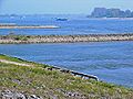
 Bijland
 -
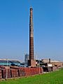 Factory
 -
 Apartment buildings on the Rhine


References
- ^ a b c "Kerncijfers wijken en buurten 2021". Central Bureau of Statistics. Retrieved 26 March 2022.
- ^ "Postcodetool for 6916AA". Actueel Hoogtebestand Nederland (in Dutch). Het Waterschapshuis. Retrieved 26 March 2022.
- ^ a b "Tolkamer - (geografische naam)". Etymologiebank (in Dutch). Retrieved 26 March 2022.
- ^ a b Ronald Stenvert & Sabine Broekhoven (2000). "Tolkamer" (in Dutch). Zwolle: Waanders. ISBN 90 400 9406 3. Retrieved 26 March 2022.
- ^ a b "Tolkamer". Plaatsengids (in Dutch). Retrieved 26 March 2022.
 | This Gelderland location article is a stub. You can help Wikipedia by expanding it. |
- v
- t
- e


