Tri-State Peak
Mountain at the convergence of the U.S. states of Kentucky, Tennessee, and Virginia
36°36′03″N 83°40′28″W / 36.60083°N 83.67444°W / 36.60083; -83.67444 (Tri-State Peak)Tri-State Peak is a mountain located in the Cumberland Gap National Historical Park, near the "saddle" of the gap. It gets its name from being on the tripoint of the state of Kentucky, Tennessee, and Virginia.
The elevation at the tri-state marker is 1,990 feet (610 m).[2] The marker can be accessed via the "tri-state peak trail," (via connections with the Gap trail and the Object Lesson Road trail) and is about 1.2 miles (1.9 km) from the park's visitor's center.[3]
The site also includes a marker denoting the location as being on the "Royal Colonial Boundary of 1665," which was marked by the American Society of Civil Engineers.
-
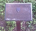 Royal Colonial Boundary of 1665 plaque
 -
 Marker for Tennessee at Tri-State Peak
 -
 Marker for the KY-TN-VA tripoint


See also
References
- ^ United States Geological Survey (2016). Middlesboro South (PDF) (Topographic map). 1:24,000. 7.5 Minute Series. Reston, VA: United States Geological Survey. Retrieved October 21, 2020.
- ^ "Tri-State Peak at Cumberland Gap". Archived from the original on 2007-02-10.
- ^ "Trails at Cumberland Gap". Archived from the original on 2007-02-10.
- v
- t
- e
Visitor attractions of the Eastern Kentucky Coalfield
| State | |
|---|---|
| Federal | |
| Interstate |


- Barthell Coal Mining Camp
- Bell County Coal House & Museum
- Bell County Historical Society Museum
- Big Sandy Heritage Center
- Blue Heron Coal Mining Camp
- Bobby Davis Museum and Park
- Breathitt County Museum
- C.B. Caudill Store & History Center
- Cloverfork Museum
- Coal Miners' Museum
- Cumberland Inn Museum
- David A. Zegeer Coal-Railroad Museum
- East Kentucky Science Center
- Elkhorn City Railroad Museum
- F.M. Stafford House
- Harland Sanders Café & Museum
- Hensley Settlement
- Highlands Museum and Discovery Center
- Kentucky Coal Mining Museum
- Kentucky Folk Art Center
- Knox Historical Museum
- Magoffin County Pioneer Village and Museum
- Marie Stewart Museum & Craft Shop
- McCreary County Museum
- Morgan County History Museum
- Mountain Homeplace
- Mountain Life Museum
- Northeastern Kentucky Museum
- Samuel May House
- Swamp Valley Museum
- U.S. 23 Country Music Highway Museum
- Wolfe County History Museum
- Black Mountain
- Cumberland Falls
- Cumberland Gap
- Dog Slaughter Falls
- Eagle Falls
- Middlesboro crater
- Pine Mountain
- Pound Gap
- Raven Rock
- Red River Gorge
- Tri-State Peak
- Yahoo Arch
- Yahoo Falls
- Bad Branch Falls State Nature Preserve
- Bat Cave and Cascade Caverns State Nature Preserves
- Big South Fork Scenic Railway
- Black Mountain Off-Road Adventure Area
- Cumberland Gap Tunnel
- Furnace Mountain
- Kentucky Reptile Zoo
- Mayo Mansion
- Middle Creek Battlefield
- Nada Tunnel
- Pikeville Cut-Through
- Pilot Knob State Nature Preserve
- Sheltowee Trace Trail
Mountains of Kentucky | |
|---|---|
| |
 Kentucky portal Kentucky portal |
 | This Bell County, Kentucky state location article is a stub. You can help Wikipedia by expanding it. |
- v
- t
- e
 | This Claiborne County, Tennessee geography–related article is a stub. You can help Wikipedia by expanding it. |
- v
- t
- e
 | This Lee County, Virginia state location article is a stub. You can help Wikipedia by expanding it. |
- v
- t
- e


