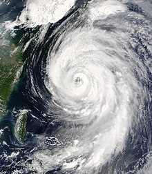
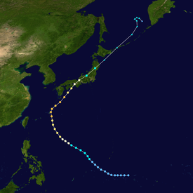
Typhoon Etau, known in the Philippines as Typhoon Kabayan,[1] produced near-record winds and rainfall in Japan in August 2003. The tenth named storm and fifth typhoon of the 2003 Pacific typhoon season, Etau developed on August 2, and gradually intensified while moving to the northwest. Etau formed an eye and became a large storm by the time it approached Okinawa on August 7. The typhoon attained peak winds of 155 km/h (96 mph) before weakening slightly while turning to the northeast. Etau made landfall on the Japanese island of Shikoku on August 8, and later moved across portions of Honshu and Hokkaido. After weakening to tropical storm status, the cyclone became extratropical on August 9 and dissipated three days later.
While passing northeast of the Philippines, the typhoon caused light damage in the archipelago. The eye crossed over Okinawa, where Etau left 166,800 people without power and caused 10 injuries. Near where Etau first struck Japan, Muroto reported a peak wind gust of 166 km/h (103 mph), at the time the third strongest on record there. The typhoon also dropped torrential rainfall peaking at 683 mm (26.9 in). The combination of winds and rainfall caused landslides, particularly on Hokkaido. Nationwide, Etau killed 20 people, destroyed 708 houses, and caused ¥35.1 billion (JPY, $294.8 million USD) in damage.[nb 1]
The origins of Typhoon Etau were from an area of convection that persisted along the west side of a weak circulation near Chuuk State on July 31. With initially moderate but steadily decreasing wind shear, the system was able to organize as it moved generally westward.[2] On August 2, the Joint Typhoon Warning Center (JTWC)[nb 2] initiated advisories on Tropical Depression 11W.[4] That day, another circulation was developing on the western side of the system, briefly classified by the Taiwan Central Weather Bureau as a tropical depression. The eastern circulation became dominant with pronounced outflow to the south, although it was initially broad and elongated.[2] Later on August 2, the Japan Meteorological Agency (JMA)[nb 3] classified the system as a tropical depression to the northeast of Yap.[5]
With a subtropical ridge in the vicinity of the Marianas Islands, the nascent depression moved to the northwest.[2] On August 3, the JMA upgraded the depression to tropical storm status, naming it Etau.[5] An upper-level low to the northeast improved northerly outflow, allowing the storm to strengthen quickly.[4] On August 4 the Philippine Atmospheric, Geophysical and Astronomical Services Administration (PAGASA) began issuing advisories as the storm approached the region, naming it Kabayan.[1] Late on August 4, the JMA upgraded Etau to typhoon status,[5] with the storm later developing an eye. An approaching shortwave trough weakened the ridge, causing Etau to turn more to the north.[2] At around 0030 UTC on August 7, the typhoon made its closest approach to Okinawa,[5] passing within 120 km (75 mi), and close enough for the 100 km (62 mi) wide eye to cross over the island.[2][6] Later that day, the JMA estimated peak maximum sustained winds of 155 km/h (96 mph), sustained over a duration of 10 minutes;[5] the JTWC estimated 1 minute winds of 205 km/h (127 mph).[4]
After reaching peak winds, Etau began turning to the north-northeast due to the approaching trough, passing near Amami Ōshima. By that time, the typhoon had become large, with gale-force winds extending 870 km (540 mi) in diameter.[2] Increasing wind shear and cooler air caused Etau to weaken.[4] The typhoon still maintained 10 minute winds of 140 km/h (87 mph) when it made landfall near Muroto on the Japanese island of Shikoku, shortly before 1300 UTC on August 8. Continuing northeastward, the typhoon weakened into a severe tropical storm as it passed near Awaji Island, before making landfall on Honshu near Nishinomiya at 2100 UTC on August 8.[5] While accelerating to the northeast, Etau lost tropical characteristics over land. After briefly reaching open waters to the northeast of Honshu, the storm made its final landfall near Erimo, Hokkaido at 1630 UTC on August 9, shortly before becoming extratropical. This was based on analysis from the JMA,[5] whereas the JTWC assessed the storm remaining offshore Hokkaido.[4] The remnants of Etau entered the Sea of Okhotsk and persisted for several more days, dissipating on August 12 to the west of the Kamchatka Peninsula.[5]
Rough waves from Typhoon Etau produced rip currents on Saipan that swept up four swimmers, who were later rescued after holding onto a buoy.[7] The outer periphery of the storm caused P36.98 million (PHP, $673,000 USD) in damage,[nb 4] mostly to infrastructure with some minor crop damage.[9] Late in its duration, Etau caused damage in Russia's Kuril Islands.[10]
While Etau was in the vicinity of Okinawa, wind gusts at Kadena Air Base reached 181 km/h (112 mph).[4] Rainfall on Okinawa peaked at 215 mm (8.5 in), while on nearby Yakushima to the north, rainfall reached 57 mm (2.2 in).[11] Throughout Okinawa prefecture, the typhoon left 166,800 buildings without power due to the strong winds. Etau damaged seven buildings, blocked one road, and caused moderate damage to crops and fisheries.[6] In the Amami Islands, about 45,000 houses, lost power due to high winds from the storm, affecting 53% of residents. Etau injured ten people in the island group, including one man who was blown off his roof.[12] Officials closed the Naha Airport due to the typhoon, causing 293 flights in the region to be canceled.[13] Ahead of the storm, ExxonMobil oil refineries in Okinawa were closed, but were reopened after sustaining minimal damage.[14]
On Shikoku, Muroto reported typhoon-force winds for eight hours,[2] and wind gusts peaked at 166 km/h (103 mph).[15] At the time, this was the third strongest gust ever reported there, behind Typhoon Nancy in 1961 and Typhoon Shirley in 1965.[2] Sustained winds there reached 180 km/h (110 mph).[16] In Tokushima Prefecture, Etau dropped heavy rainfall peaking at 683 mm (26.9 in), although similarly heavy totals of 639 and 543 mm (25.2 and 21.4 in) were reported in Kōchi and Miyazaki prefectures, respectively. About 95% of the rainfall total in Kōchi fell in 24 hours. In Miyazaki, a station reported an hourly rainfall total of 79 mm (3.1 in).[15] Rainfall at Biratori, Hokkaido reached 306.2 mm (12.06 in) in a 48‑hour period, the highest at the station since records began in 1962. The heavy rainfall caused landslides across Hokkaido, particularly in areas where rainfall totaled over 330 mm (13 in). In the area around the Saru River, shallow landslides displaced about 13,000,000 m3 (460,000,000 cu ft) of soil, of which about 190,000 m3 (6,700,000 cu ft) entered the river.[17] This caused the highest sediment levels in the river since the 1960s,[18] washing about 50,000 m3 (1,800,000 cu ft) into the Nibutani Dam.[17] Landslides also swept about 65,000 m3 (2,300,000 cu ft) of soil and trees into the Appetsu River, which caused additional damage by washing away adjacent homes and bridges.[17] In addition the rainfall, Etau spawned a weak tornado near Kumagaya on the Honshu mainland, rated around an F1.[19] The typhoon brought a plume of warm air to the country that caused the warmest temperatures of the year at that point.[20]
The heavy rainfall in Tokushima caused landslides and blocked roads, resulting in disruptions to bus and train service. Strong winds overturned a truck, injuring the two occupants.[21] In Muroto, several people were injured by flying glass. Rough waves killed two people in the same city,[16] one in Fukuoka,[22] damaged the seawall in Kyoto,[23] and damaged 25 ships.[15] In Takamatsu, Kagawa, Etau left about ¥1.2 billion (JPY, $10 million USD) in crop damage, mainly due to damaged greenhouses.[24] Two workers were killed in Higashiuwa after being swept away by a river.[25] On Hokkaido, heavy rainfall caused landslides, damaging hundreds of roads and bridges and isolating several villages.[26] River flooding swept away a vehicle in Kamishihoro, killing the five occupants.[27] Along Mount Poroshiri, 29 people were rescued by helicopter from a mountain lodge after Etau blocked off their descending trail.[28]
Throughout Japan, Etau caused over 1,000 flights to be canceled,[29] and for bullet trains to operate at a slower speed, causing delays.[30] About 62,000 people lost power during the storm, and across the country.[31] The typhoon destroyed 708 houses and flooded 2,253 others,[15] causing over 6,000 people to evacuate to storm shelters.[31] About 295 ha (730 acres) of fields were damaged. Throughout Japan, Etau killed 20 people and injured 93 others, 19 of them seriously. Overall damage totaled ¥35.1 billion (JPY, US$294.8 million).[nb 5][15] Largely because Etau remained tropical and weakened over Japan, damage was much less than Typhoon Tokage a year later, which produced comparable rainfall totals at a similar intensity but struck the country while extratropical.[33]
^All damage totals are in 2003 values of their respective currencies.
^The Joint Typhoon Warning Center is a joint United States Navy – United States Air Force task force that issues tropical cyclone warnings for the western Pacific Ocean and other regions.[3]
^The total was originally reported in Philippine pesos. Total converted via the Oanda Corporation website.[8]
^The total was originally reported in Japanese yen. Total converted via the Oanda Corporation website.[32]
References
^ abTyphoon "Kabayan" (04-06 August 2003) (Report). Philippine Atmospheric, Geophysical and Astronomical Services Administration. Archived from the original on 5 November 2013. Retrieved 2013-11-03.
^ abcdefghKevin Boyle. "Monthly Global Tropical Cyclone Summary August 2003". Gary Padgett. Retrieved 2013-10-12.
^"Joint Typhoon Warning Center Mission Statement". Joint Typhoon Warning Center. 2011. Archived from the original on 2007-07-26. Retrieved 2012-07-25.
^ abcdefJoint Typhoon Warning Center. Typhoon (TY) 11W (Etau) (PDF) (Report). United States Navy. Archived from the original (PDF) on 2013-02-21. Retrieved 2013-10-12.
^ abcdefghiAnnual Report on Activities of the RSMC Tokyo – Typhoon Center 2003 (PDF) (Report). Japan Meteorological Agency. 8. Retrieved 2013-11-03.
^Event Details for Saipan (Report). National Climatic Data Center. Retrieved 2013-11-06.
^"Historical Exchange Rates". Oanda Corporation. 2013. Archived from the original on 2013-10-04. Retrieved 2013-11-03.
^Destructive Typhoons 1970-2003 (Report). National Disaster Coordinating Council Office of Civil Defense Operations Center. Retrieved 2013-11-03.
^2003 Flood Archive (Report). Dartmouth Flood Observatory. 2004-01-05. Archived from the original on 2014-10-06. Retrieved 2013-11-04.
^List of AMeDAS Observation Stations (Report). Digital Typhoon. Retrieved 2013-11-04.
^Weather Disaster Report (2003-827-24) (Report). Digital Typhoon. Retrieved 2013-11-04.
^"Typhoon Etau expected to hit western Japan on Fri". Japan Economic Newswire. 2003-08-07. – via Lexis Nexis (subscription required)
^"Refinery operations in Western Japan". Platt's Petrochemical Report. 2003-08-15. – via Lexis Nexis (subscription required)
^ abcdeTyphoon 200310 (Etau) (Report). Digital Typhoon. Retrieved 2013-11-04.
^ abWeather Disaster Report (2003-893-08) (Report). Digital Typhoon. Retrieved 2013-11-04.
^ abcYasuhiro Murakami; Osamu Shimizu; Hajime Sato; Takashi Yamada (2008). "Sediment-related Disaster Caused by Typhoon 0310 (Etau) in Hidaka Region of Hokkaido, Japan" (PDF). International Journal of Erosion Control Engineering. 1. Japan Society of Erosion Control Engineering. Archived from the original (PDF) on 2013-11-05. Retrieved 2013-11-04.
^Satoshi Miyazaki; et al. (December 2011). Suspended sediment from different geological sources in a watershed determined by natural radionuclides. American Geophysical Union, Fall Meeting 2011. Bibcode:2011AGUFMEP41B0612M.
^Weather Disaster Report (2003-626-06) (Report). Digital Typhoon. Retrieved 2013-11-04.
^"Heat wave spreads across Japan, Kanto hottest". Japan Economic Newswire. 2003-08-10. – via Lexis Nexis (subscription required)
^Weather Disaster Report (2003-895-10) (Report). Digital Typhoon. Retrieved 2013-11-04.
^Weather Disaster Report (2003-807-09) (Report). Digital Typhoon. Retrieved 2013-11-04.
^Weather Disaster Report (2003-759-13) (Report). Digital Typhoon. Retrieved 2013-11-04.
^Weather Disaster Report (2003-891-19) (Report). Digital Typhoon. Retrieved 2013-11-04.
^Weather Disaster Report (2003-887-14) (Report). Digital Typhoon. Retrieved 2013-11-04.
^Weather Disaster Report (2003-428-02) (Report). Digital Typhoon. Retrieved 2013-11-04.
^"2 bodies found, 5 still missing in Hokkaido". Japan Economic Newswire. 2003-08-12. – via Lexis Nexis (subscription required)
^"29 rescued from mountain lodge following typhoon". Japan Economic Newswire. 2003-08-12. – via Lexis Nexis (subscription required)
^"Int'l flights drop on SARS, domestic flights weak on typhoon". Japan Economic Newswire. 2003-08-18. – via Lexis Nexis (subscription required)
^ ab"Typhoon rakes Japan, 3 dead, 3 missing in wake". Japan Economic Newswire. 2003-08-09. – via Lexis Nexis (subscription required)
^"Historical Exchange Rates". Oanda Corporation. 2013. Archived from the original on 2013-10-04. Retrieved 2013-11-04.
^Dr. Peter Sousounis; Jason Butke (2009-05-14). Effect of Extratropical Transitioning on Pacific Typhoons (Report). AIR Worldwide. Retrieved 2013-11-04.
External links
Wikimedia Commons has media related to Typhoon Etau (2003).
JMA General Information of Typhoon Etau (0310) from Digital Typhoon
JMA Best Track Data of Typhoon Etau (0310) (in Japanese)
JMA Best Track Data (Graphics) of Typhoon Etau (0310)
JMA Best Track Data (Text)
JTWC Best Track Data Archived 2018-09-25 at the Wayback Machine of Typhoon 11W (Etau)
11W.ETAU Archived 2021-12-10 at the Wayback Machine from the U.S. Naval Research Laboratory


 Extratropical cyclone, remnant low, tropical disturbance, or monsoon depression