Wyndham Street
| Wyndham Street | |||||||||||||
|---|---|---|---|---|---|---|---|---|---|---|---|---|---|
 Wyndham Street | |||||||||||||
| Traditional Chinese | 雲咸街 | ||||||||||||
| Simplified Chinese | 云咸街 | ||||||||||||
| |||||||||||||


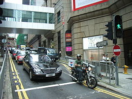
Wyndham Street is a one-way street in Central, Hong Kong. It is one of the earliest colonial streets, once known as Pedder Hill.
Location
It starts at the junction with Hollywood Road and Arbuthnot Road, near the Central Police Station, and heads downhill to terminate at Queen's Road Central, near the Entertainment Building.
History
Lieutenant William Pedder[1] the first lieutenant of the Nemesis[2] was the first harbour master of Hong Kong, and established Pedder Street as the centre of Victoria City's commerce in the early colonial days. Pedder had his office built on the rocks above what is now Wyndham Street. For many years, the site on the top was known as Pedder's Hill.[3]
In the early 20th century, Wyndham Street was nicknamed "Flower Street" because of the numerous stalls selling flowers. In 1928, the flower stalls were moved to D'Aguilar Street and the "Flower Street" name became attached to the new location.[4]
On 18 August 1997, a Mitsubishi Lancer crashed on Wyndham Street, resulting in the death of 3 people and injuring 10 others.
See also
References
- ^ For more on Lieutenant William Pedder see: O'Byrne, William R. (1849). "Pedder, William" . A Naval Biographical Dictionary. London: John Murray.
- ^ Welsh, Frank (1997). A History of Hong Kong. Great Britain: Harper Collins Publishers. p. 133.
- ^ Eric Cavaliero, Pedder Street was where it all happened Archived 22 May 2011 at the Wayback Machine, The Standard, 13 August 1998
- ^ Bard, Solomon (2002). Voices from the past: Hong Kong, 1842-1918. Hong Kong University Press. p. 157. ISBN 978-9622095748.
Further reading
- Wang, Gang (2008). 圖說雲咸街滄桑 : 1840年代-1960年代 [An illustrated story of Wyndham Street, Hong Kong : 1840s-1960s] (in Chinese). Hong Kong: Chung Hwa Book Company (Hong Kong) Limited. ISBN 9789628885008. OCLC 260299109.
External links
Wikimedia Commons has media related to Wyndham Street.
- Google Maps of Wyndham Street
- v
- t
- e
- Aberdeen Street
- Arbuthnot Road
- Battery Path
- Belcher's Street
- Bonham Road
- Bonham Strand
- Bonham Strand West
- Bridges Street
- Caine Road
- Centre Street
- Chater Road
- Cochrane Street
- Conduit Road
- Connaught Road Central
 Connaught Road West
- Connaught Place
- Davis Street
- Des Voeux Road Central
- Des Voeux Road West
- Duddell Street
- Elgin Street
- Eastern Street
- Gage Street
- Garden Road
- Glenealy
- Gutzlaff Street
- Harcourt Road
- Hollywood Road
- Ice House Street
- Jubilee Street
- Ladder Street
- Lan Kwai Fong
- Lugard Road
- MacDonnell Road
- Magazine Gap Road
- Mosque Street
- Old Bailey Street
- On Lan Street
- Po Hing Fong
- Pottinger Street
- Peel Street
- Queen Victoria Street
- Queen's Road Central
- Queen's Road West
- Queensway
- Robinson Road
- Shelley Street
- Smithfield
- Staveley Street
- Tai Ping Shan Street
- Upper Albert Road
- Upper Lascar Row
- Water Street
- Wellington Street
- Western Street
- Wing Kut Street
- Wing On Street
- Wing Sing Street
- Wyndham Street

- Arsenal Street
- Amoy Street
- Blue Pool Road
 Canal Road
- Causeway Road
- Gloucester Road
- Gresson Street
- Hennessy Road
- Jaffe Road
- Jardine's Bazaar
- Johnston Road
- Lee Tung Street
- Lockhart Road
- Luard Road
- Oi Kwan Road
- Paterson Street
- Queen's Road East
- Stone Nullah Lane
- Stubbs Road
- Swatow Street
- Tai Yuen Street
- Thomson Road
- Victoria Park Road
- Yee Wo Street

22°16′50″N 114°09′18″E / 22.280479°N 114.155002°E / 22.280479; 114.155002
 | This Hong Kong road article is a stub. You can help Wikipedia by expanding it. |
- v
- t
- e


