Yitav
Israeli settlement and moshav shitufi in the southern Jordan Valley of the West Bank
Place in Judea and Samaria Area
31°56′50″N 35°25′23″E / 31.94722°N 35.42306°E / 31.94722; 35.42306 (2022)[1]
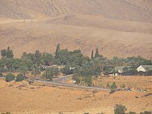
Yitav (Hebrew: יִיטַ"ב, an abbreviation of Yad Yitzhak Tabenkin) is an Israeli settlement and moshav shitufi in the southern Jordan Valley of the West Bank.[2] Located just north of Jericho and west of the Palestinian village of al-Auja, it falls under the jurisdiction of Bik'at HaYarden Regional Council.[2] In 2022 it had a population of 261.
The international community considers Israeli settlements in the West Bank illegal under international law, but the Israeli government disputes this.[3]
History
According to ARIJ, Israel confiscated 499 dunams of land from the Palestinian village of Al-Auja in order to construct Yitav.[4]
Niran was established as a Nahal settlement in 1970, Yitav was recognised by the state in 1977, and began operating as a kibbutz.[2] It was named a memorial (Hebrew: yad) to Yitzhak Tabenkin, one of the leaders of the Israeli kibbutz movement.[citation needed] It subsequently reorganized into a moshav shitufi (though remaining within the Kibbutz Movement), whose members today are immigrants from the former Soviet Union (34 families). [citation needed]
Nature
Subtropical agriculture is the main economic activity in Yitav (dates, bananas, vegetables), although some members have outside jobs in the surrounding area or in Jerusalem.[citation needed]
Yitav Nature Reserve located 4 km west of Yitav covers the canyon of Nahal Yitav (Wadi al-Auja) with its springs.[citation needed]
References
External links
- Yitav on Bik'at HaYarden Regional Council site (in Hebrew).
 | This geography of the State of Palestine article is a stub. You can help Wikipedia by expanding it. |
- v
- t
- e


