Zacatecoluca
You can help expand this article with text translated from the corresponding article in Spanish. (June 2023) Click [show] for important translation instructions.
- Machine translation, like DeepL or Google Translate, is a useful starting point for translations, but translators must revise errors as necessary and confirm that the translation is accurate, rather than simply copy-pasting machine-translated text into the English Wikipedia.
- Do not translate text that appears unreliable or low-quality. If possible, verify the text with references provided in the foreign-language article.
- You must provide copyright attribution in the edit summary accompanying your translation by providing an interlanguage link to the source of your translation. A model attribution edit summary is
Content in this edit is translated from the existing Spanish Wikipedia article at [[:es:Zacatecoluca]]; see its history for attribution. - You may also add the template
{{Translated|es|Zacatecoluca}}to the talk page. - For more guidance, see Wikipedia:Translation.
Municipality in La Paz, El Salvador

Flag

Seal
 El Salvador
 (2016 census)

Zacatecoluca (Spanish pronunciation: [sakatekoˈluka]) is the capital municipality of the La Paz Department of El Salvador.
Located in Southern El Salvador, in the Rio Lempa valley, at the foot of San Vicente (Chinchotepec) Volcano. A commercial center for the surrounding agricultural area, it also trades in cotton goods, baskets, salt, and lumber.
History
An earthquake in 1932 caused severe damage.
Zacatecoluca was the birthplace of José Simeón Cañas, who fought for and secured the emancipation of slaves in Central America by Spaniards in 1825.
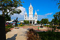
Zacatecoluca houses many traditional Spanish buildings including the Santa Lucia Catholic Church and used to hold the house where José Simeón Cañas lived, until poor economy due to the many years of war caused the local government to sell the house to a supermarket branch, the house was destroyed and a poorly marked stone on the left of the supermarket entrance is all that is left of Cañas' housing legacy.
Santa Lucia Catholic Church holds a dear history to the people of Zacatecoluca, as an image of Virgin Mary placed on top is said to have stopped an eruption of lava and ash from completely destroying the city and its local population. On May 11, 1844, Zacatecoluca received the title of Generous and Loyal City becoming the Departmental Head of La Paz on February 21, 1852.
Geography
Climate
| Climate data for Zacatecoluca | |||||||||||||
|---|---|---|---|---|---|---|---|---|---|---|---|---|---|
| Month | Jan | Feb | Mar | Apr | May | Jun | Jul | Aug | Sep | Oct | Nov | Dec | Year |
| Mean daily maximum °C (°F) | 32.1 (89.8) | 32.2 (90.0) | 33.3 (91.9) | 33.1 (91.6) | 31.7 (89.1) | 30.2 (86.4) | 31.4 (88.5) | 30.8 (87.4) | 29.7 (85.5) | 29.8 (85.6) | 30.5 (86.9) | 31.0 (87.8) | 31.3 (88.4) |
| Daily mean °C (°F) | 24.4 (75.9) | 24.5 (76.1) | 26.0 (78.8) | 26.5 (79.7) | 26.0 (78.8) | 25.0 (77.0) | 25.4 (77.7) | 25.0 (77.0) | 24.4 (75.9) | 24.3 (75.7) | 24.2 (75.6) | 23.8 (74.8) | 25.0 (76.9) |
| Mean daily minimum °C (°F) | 16.7 (62.1) | 16.8 (62.2) | 18.7 (65.7) | 19.9 (67.8) | 20.3 (68.5) | 19.8 (67.6) | 19.5 (67.1) | 19.2 (66.6) | 19.2 (66.6) | 18.9 (66.0) | 17.9 (64.2) | 16.7 (62.1) | 18.6 (65.5) |
| Average precipitation mm (inches) | 9 (0.4) | 3 (0.1) | 14 (0.6) | 47 (1.9) | 200 (7.9) | 379 (14.9) | 318 (12.5) | 327 (12.9) | 412 (16.2) | 328 (12.9) | 60 (2.4) | 8 (0.3) | 2,105 (83) |
| Source: Climate-Data.org[1] | |||||||||||||
Sports
The local professional football club is named Platense and they are former national league champions. They currently play in the Salvadoran First Division.
Gallery
-
 San Sebastian Analco church.
 -
 Concha Acústica.
 -
 José Simeón Cañas monument.
 -
 Zacatecoluca's history center.


References
- ^ "Climate: Zacatecoluca". Climate-Data.org. 9 May 2018.
- v
- t
- e
 La Paz Department
Capital: Zacatecoluca
- Cuyultitán
- El Rosario
- Jerusalén
- Mercedes La Ceiba
- Olocuilta
- Paraíso de Osorio
- San Antonio Masahuat
- San Emigdio
- San Francisco Chinameca
- San Juan Nonualco
- San Juan Talpa
- San Juan Tepezontes
- San Luis La Herradura
- San Luis Talpa
- San Miguel Tepezontes
- San Pedro Masahuat
- San Pedro Nonualco
- San Rafael Obrajuelo
- Santa María Ostuma
- Santiago Nonualco
- Tapalhuaca
- Zacatecoluca

Authority control databases | |
|---|---|
| International |
|
| National |
|


