Zitadelle (Berlin U-Bahn)
| Preceding station | Berlin U-Bahn | Following station | ||
|---|---|---|---|---|
| Altstadt Spandau towards Rathaus Spandau | U7 | Haselhorst towards Rudow | ||
Location | |
|---|---|
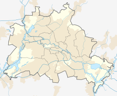
  Zitadelle Location within Berlin |
Zitadelle is a station on the Berlin U-Bahn line U7. It was opened on 1 October 1984 with the line's extension from Rohrdamm to Rathaus Spandau. Its name means "Citadel" in English and it was named for the historic Spandau Citadel. Unlike most U-Bahn stations, Zitadelle has side platforms. The station's interiors were also designed to resemble the citadel's style.

It lies between the stations Altstadt Spandau and Haselhorst. It was built/opened by R.G.Rümmler in 1984 (planned was the name "Am Juliusturm"). This station has side platforms because during its construction the important street above could not be blocked. So first the northern platform was built then the southern. The next station is Haselhorst.[2]
References
External links
- v
- t
- e

- Warschauer Straße
- Stralauer Tor (dismantled)
- Schlesisches Tor
- Görlitzer Bahnhof
- Kottbusser Tor
- Prinzenstraße
- Hallesches Tor
- Möckernbrücke
- Gleisdreieck
- Kurfürstenstraße
- Nollendorfplatz
- Wittenbergplatz
- Kurfürstendamm
- Uhlandstraße
- Pankow
- Vinetastraße
- Schönhauser Allee
- Eberswalder Straße
- Senefelderplatz
- Rosa-Luxemburg-Platz
- Alexanderplatz
- Klosterstraße
- Märkisches Museum
- Spittelmarkt
- Hausvogteiplatz
- Stadtmitte
- Mohrenstraße
- Potsdamer Platz
- Mendelssohn-Bartholdy-Park
- Gleisdreieck
- Bülowstraße
- Nollendorfplatz
- Wittenbergplatz
- Zoologischer Garten
- Ernst-Reuter-Platz
- Deutsche Oper
- Bismarckstraße
- Sophie-Charlotte-Platz
- Kaiserdamm
- Theodor-Heuss-Platz
- Neu-Westend
- Olympia-Stadion
- Ruhleben
- Warschauer Straße
- Stralauer Tor (dismantled)
- Schlesisches Tor
- Görlitzer Bahnhof
- Kottbusser Tor
- Prinzenstraße
- Hallesches Tor
- Möckernbrücke
- Gleisdreieck
- Kurfürstenstraße
- Nollendorfplatz
- Wittenbergplatz
- Augsburger Straße
- Nürnberger Platz (dismantled)
- Spichernstraße
- Hohenzollernplatz
- Fehrbelliner Platz
- Heidelberger Platz
- Rüdesheimer Platz
- Breitenbachplatz
- Podbielskiallee
- Dahlem-Dorf
- Freie Universität (Thielplatz)
- Oskar-Helene-Heim
- Onkel Toms Hütte
- Krumme Lanke
- Nollendorfplatz
- Viktoria-Luise-Platz
- Bayerischer Platz
- Rathaus Schöneberg
- Innsbrucker Platz
- Hauptbahnhof
- Bundestag
- Brandenburger Tor
- Unter den Linden
- Museumsinsel
- Rotes Rathaus
- Alexanderplatz
- Schillingstraße
- Strausberger Platz
- Weberwiese
- Frankfurter Tor
- Samariterstraße
- Frankfurter Allee
- Magdalenenstraße
- Lichtenberg
- Friedrichsfelde
- Tierpark
- Biesdorf-Süd
- Elsterwerdaer Platz
- Wuhletal
- Kaulsdorf Nord
- Kienberg (Gärten der Welt)
- Cottbusser Platz
- Hellersdorf
- Louis-Lewin-Straße
- Hönow
- Alt-Tegel
- Borsigwerke
- Holzhauser Straße
- Otisstraße
- Scharnweberstraße
- Kurt-Schumacher-Platz
- Afrikanische Straße
- Rehberge
- Seestraße
- Leopoldplatz
- Wedding
- Reinickendorfer Straße
- Schwartzkopffstraße
- Naturkundemuseum
- Oranienburger Tor
- Friedrichstraße
- Unter den Linden
- Französische Straße (closed)
- Stadtmitte
- Kochstraße
- Hallesches Tor
- Mehringdamm
- Platz der Luftbrücke
- Paradestraße
- Tempelhof
- Alt Tempelhof
- Kaiserin-Augusta-Straße
- Ullsteinstraße
- Westphalweg
- Alt-Mariendorf
- Rathaus Spandau
- Altstadt Spandau
- Zitadelle
- Haselhorst
- Paulsternstraße
- Rohrdamm
- Siemensdamm
- Halemweg
- Jakob-Kaiser-Platz
- Jungfernheide
- Mierendorffplatz
- Richard-Wagner-Platz
- Bismarckstraße
- Wilmersdorfer Straße
- Adenauerplatz
- Konstanzer Straße
- Fehrbelliner Platz
- Blissestraße
- Berliner Straße
- Bayerischer Platz
- Eisenacher Straße
- Kleistpark
- Yorckstraße
- Möckernbrücke
- Mehringdamm
- Gneisenaustraße
- Südstern
- Hermannplatz
- Rathaus Neukölln
- Karl-Marx-Straße
- Neukölln
- Grenzallee
- Blaschkoallee
- Parchimer Allee
- Britz-Süd
- Johannisthaller Chaussee
- Lipschitzallee
- Wutzkyallee
- Zwickauer Damm
- Rudow
- Wittenau
- Rathaus Reinickendorf
- Karl-Bonhoeffer-Nervenklinik
- Lindauer Allee
- Paracelsus-Bad
- Residenzstraße
- Franz-Neumann-Platz
- Osloer Straße
- Pankstraße
- Gesundbrunnen
- Voltastraße
- Bernauer Straße
- Rosenthaler Platz
- Weinmeisterstraße
- Alexanderplatz
- Jannowitzbrücke
- Heinrich-Heine-Straße
- Moritzplatz
- Kottbusser Tor
- Schönleinstraße
- Hermannplatz
- Boddinstraße
- Leinestraße
- Hermannstraße
- Osloer Straße
- Nauener Platz
- Leopoldplatz
- Amrumer Straße
- Westhafen
- Birkenstraße
- Turmstraße
- Hansaplatz
- Zoologischer Garten
- Kurfürstendamm
- Spichernstraße
- Güntzelstraße
- Berliner Straße
- Bundesplatz
- Friedrich-Wilhelm-Platz
- Walther-Schreiber-Platz
- Schloßstraße
- Rathaus Steglitz
52°32′16″N 13°13′04″E / 52.53778°N 13.21778°E / 52.53778; 13.21778
This article about a railway station in Berlin is a stub. You can help Wikipedia by expanding it. |
- v
- t
- e
 | This Berlin U-Bahn-related article is a stub. You can help Wikipedia by expanding it. |
- v
- t
- e


