Sataf
Sataf صطاف | |
|---|---|
Desa | |
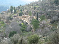 Reruntuhan desa Sataf | |
| Etimologi: dari nama personal[1] | |
| 31°46′9″N 35°7′38″E / 31.76917°N 35.12722°E / 31.76917; 35.12722 | |
| Grid Palestina | 162/130 |
| Entitas geopolitik | Mandat Palestina |
| Subdistrik | Yerusalem |
| Tanggal pengosongan | 13–14 Juli 1948[4] |
| Luas [2] | |
| • Total | 3,775 dunams (3,775 km2 or 1,458 sq mi) |
| Populasi (1945) | |
| • Total | 540[2][3] |
| Sebab pengosongan | Serangan militer oleh pasukan Yishuv |
Sataf (Arab: صطاف, Ibrani: סטף) adalah sebuah desa Palestina di Subdistrik Yerusalem yang dikosongkan pada Perang Arab-Israel 1948. Desa tersebut berjarak 10 km dari barat Yerusalem
Referensi
Daftar pustaka
- Barron, J.B., ed. (1923). Palestine: Report and General Abstracts of the Census of 1922. Government of Palestine.
- Canaan, T. (1927). Mohammedan Saints and Sanctuaries in Palestine. London: Luzac & Co. Diarsipkan dari versi asli tanggal 2019-05-16. Diakses tanggal 2020-07-21.
- Conder, C.R.; Kitchener, H.H. (1883). The Survey of Western Palestine: Memoirs of the Topography, Orography, Hydrography, and Archaeology. 3. London: Committee of the Palestine Exploration Fund.
- Government of Palestine, Department of Statistics (1945). Village Statistics, April, 1945.
- Guérin, V. (1869). Description Géographique Historique et Archéologique de la Palestine (dalam bahasa French). 1: Judee, pt. 2. Paris: L'Imprimerie Nationale. Pemeliharaan CS1: Bahasa yang tidak diketahui (link)
- Hadawi, S. (1970). Village Statistics of 1945: A Classification of Land and Area ownership in Palestine. Palestine Liberation Organization Research Center.
- Hartmann, M. (1883). "Die Ortschaftenliste des Liwa Jerusalem in dem türkischen Staatskalender für Syrien auf das Jahr 1288 der Flucht (1871)". Zeitschrift des Deutschen Palästina-Vereins. 6: 102–149.
- Khalidi, W. (1992). All That Remains: The Palestinian Villages Occupied and Depopulated by Israel in 1948. Washington D.C.: Institute for Palestine Studies. ISBN 0-88728-224-5. ISBN 0-88728-224-5.
- Mills, E., ed. (1932). Census of Palestine 1931. Population of Villages, Towns and Administrative Areas. Jerusalem: Government of Palestine.
- Morris, B. (2004). The Birth of the Palestinian Refugee Problem Revisited. Cambridge University Press. ISBN 978-0-521-00967-6.
- Palmer, E.H. (1881). The Survey of Western Palestine: Arabic and English Name Lists Collected During the Survey by Lieutenants Conder and Kitchener, R. E. Transliterated and Explained by E.H. Palmer. Committee of the Palestine Exploration Fund.
- Petersen, Andrew (2001). A Gazetteer of Buildings in Muslim Palestine (British Academy Monographs in Archaeology). 1. Oxford University Press. ISBN 978-0-19-727011-0.
- Robinson, E.; Smith, E. (1841). Biblical Researches in Palestine, Mount Sinai and Arabia Petraea: A Journal of Travels in the year 1838. 3. Boston: Crocker & Brewster.
- Schick, C. (1896). "Zur Einwohnerzahl des Bezirks Jerusalem". Zeitschrift des Deutschen Palästina-Vereins. 19: 120–127.
- Socin, A. (1879). "Alphabetisches Verzeichniss von Ortschaften des Paschalik Jerusalem". Zeitschrift des Deutschen Palästina-Vereins. 2: 135–163.
- Toledano, E. (1984). "The Sanjaq of Jerusalem in the Sixteenth Century: Aspects of Topography and Population". Archivum Ottomanicum. 9: 279–319.
Pranala luar
- Welcome To Sataf in Palestineremembered.com
- Sataf, from Zochrot
- Survey of Western Palestine, Map 17: IAA, Wikimedia commons
- Map, 1946


