Zarnuqa
Zarnuqa زرنوقة | |
|---|---|
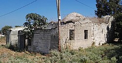 Masjid desa pada 2016. | |
| 31°52′49″N 34°47′23″E / 31.88028°N 34.78972°E / 31.88028; 34.78972 | |
| Grid Palestina | 130/143 |
| Entitas geopolitik | Mandat Palestina |
| Subdistrik | Ramle |
| Tanggal pengosongan | 27–28 Mei 1948[3] |
| Luas | |
| • Total | 7,545 dunams (7,545 km2 or 2,913 sq mi) |
| Populasi (1945) | |
| • Total | 2.380[1][2] |
| Sebab pengosongan | Pengusiran oleh pasukan Yishuv |
| Wilayah saat ini | Rehovot, Kvutzat Shiller, Gibton dan Givat Brenner |
Zarnuqa (bahasa Arab: زرنوقة), juga Zarnuga,[4] adalah sebuah desa Arab Palestina di Subdistrik Ramle. Desa tersebut dikosongkan pada 27–28 Mei 1948 dalam Perang Arab-Israel 1948.
Referensi
Daftar pustaka
- Ajami, Moshe (2007-10-17). "Zarnuqa" (119). Hadashot Arkheologiyot – Excavations and Surveys in Israel.
- Avneri, Arieh L. (1984). The Claim of Dispossession: Jewish Land-settlement and the Arabs, 1878-1948. Transaction Publishers. ISBN 0-87855-964-7.
- Barron, J.B., ed. (1923). Palestine: Report and General Abstracts of the Census of 1922. Government of Palestine.
- Belcove-Shalin, Janet S. (1995). New World Hasidim: Ethnographic Studies of Hasidic Jews in America. Suny Press. ISBN 0-79142-246-1.
- Cohen, H. (2008). Army of Shadows, Palestinian Collaboration with Zionism, 1917–1948. University of California Press. ISBN 978-0-520-25221-9.
- Conder, C.R.; Kitchener, H. H. (1882). The Survey of Western Palestine: Memoirs of the Topography, Orography, Hydrography, and Archaeology. 2. London: Committee of the Palestine Exploration Fund.
- Dagot, Angelina (2006-08-06). "Zarnuqa" (118). Hadashot Arkheologiyot – Excavations and Surveys in Israel.
- Dagot, Angelina (2008-10-05). "Zarnuqa" (120). Hadashot Arkheologiyot – Excavations and Surveys in Israel.
- Department of Statistics (1945). Village Statistics, April, 1945. Government of Palestine.
- Fogel, Peter (2007-12-18). "Zarnuqa" (119). Hadashot Arkheologiyot – Excavations and Surveys in Israel.
- Glick, Alexander (2008-07-16). "Zarnuqa" (120). Hadashot Arkheologiyot – Excavations and Surveys in Israel.
- Golan, Dor (2008-08-05). "Zarnuqa" (120). Hadashot Arkheologiyot – Excavations and Surveys in Israel.
- Guérin, Victor (1869). Description Géographique Historique et Archéologique de la Palestine. 1; Judee, pt. 2.
- Hadawi, S. (1970). Village Statistics of 1945: A Classification of Land and Area ownership in Palestine. Palestine Liberation Organization Research Center.
- Hartmann, M. (1883). "Die Ortschaftenliste des Liwa Jerusalem in dem türkischen Staatskalender für Syrien auf das Jahr 1288 der Flucht (1871)". Zeitschrift des Deutschen Palästina-Vereins. 6: 102–149.
- Johnson, Penny: Take My Camel: The Disappearing Camels of Jerusalem and Jaffa, jerusalemquarterly.org
- Karmon, Y. (1960). "An Analysis of Jacotin's Map of Palestine" (PDF). Israel Exploration Journal. 10 (3,4): 155–173; 244–253. Diarsipkan dari versi asli (PDF) tanggal 2019-12-22. Diakses tanggal 2020-07-23.
- Khalidi, W. (1992). All That Remains: The Palestinian Villages Occupied and Depopulated by Israel in 1948. Washington D.C.: Institute for Palestine Studies. ISBN 0-88728-224-5.
- Karlinsky, Nahum (2012). California Dreaming: Ideology, Society, and Technology in the Citrus Industry of Palestine, 1890-1939. Suny Press. ISBN 0-79148-291-X.
- Marmelstein, Yitzhak (2014-09-08). "Zarnuqa" (126). Hadashot Arkheologiyot – Excavations and Surveys in Israel.
- Mills, E., ed. (1932). Census of Palestine 1931. Population of Villages, Towns and Administrative Areas. Jerusalem: Government of Palestine.
- Morris, B. (2004). The Birth of the Palestinian Refugee Problem Revisited. Cambridge University Press. ISBN 978-0-521-00967-6.
- Palmer, E.H. (1881). The Survey of Western Palestine: Arabic and English Name Lists Collected During the Survey by Lieutenants Conder and Kitchener, R. E. Transliterated and Explained by E.H. Palmer. Committee of the Palestine Exploration Fund.
- Petersen, Andrew (2001). A Gazetteer of Buildings in Muslim Palestine (British Academy Monographs in Archaeology). 1. Oxford University Press. ISBN 978-0-19-727011-0.
- Reuter, Christoph (2004). My Life is a Weapon: A Modern History of Suicide Bombing
 . Princeton University Press. ISBN 0-69111-759-4.
 - Robinson, E.; Smith, E. (1841). Biblical Researches in Palestine, Mount Sinai and Arabia Petraea: A Journal of Travels in the year 1838. 3. Boston: Crocker & Brewster.
- Socin, A. (1879). "Alphabetisches Verzeichniss von Ortschaften des Paschalik Jerusalem". Zeitschrift des Deutschen Palästina-Vereins. 2: 135–163.
- Warren, C. (1871). "The plains of Philistia". Quarterly statement - Palestine Exploration Fund. 3: 29–37.

Pranala luar
- Welcome To Zarnuqa
- Zarnuqa, Zochrot
- Survey of Western Palestine, Map 16: IAA, Wikimedia commons
- Zarnuqa from the Khalil Sakakini Cultural Center


