Broutonbaai
| Broutonbaai | ||||
|---|---|---|---|---|
  | ||||
| Situering | ||||
| Locatie | Simoesjir | |||
| Hoogte | 0 m | |||
| Coördinaten | 47° 9′ NB, 152° 13′ OL | |||
| Basisgegevens | ||||
| Oppervlakte | 14,66 km² | |||
| Soort water | kratermeer | |||
| Kustlengte | 18 km | |||
| Maximale lengte | 5,8 km | |||
| Maximale breedte | 2,3 km | |||
| Maximale diepte | 240 m | |||
| Overig | ||||
| Belangrijkste bronnen | Zee van Ochotsk | |||
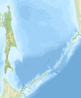
| Eiland(en) | Koerilen | |||
| Foto's | ||||
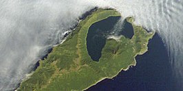 | ||||
satellietfoto van de Broughtonbaai | ||||
| ||||

De Broutonbaai (Russisch: бухта Броутона; Boechta Bro-oetona) is een baai gevormd in de caldeira van de vulkaan Oeratman aan de noordkant van het eiland Simoesjir op de Koerilen, Rusland.[1]
De baai is vernoemd naar William Robert Broughton, die Simoesjir (toen Marikan) in oktober 1796 onderzocht.[2]
Tijdens het Sovjettijdperk deden de Russen pogingen om voor de Rodebaniervloot een geheime duikbootbasis te bouwen in het noordoostelijke deel van de baai.[3]
Bronnen, noten en/of referenties
- ↑ Global Volcanism Program: Urataman
- ↑ Broughton, William Robert (1804). A Voyage of Discovery to the North Pacific Ocean; in which the coast of Asia, from the latitude of 35° north to the latitude of 52° north, the island of Insu (commonly known under the name of Jesus), the north, south and east coasts of Japan, the Lieuchieux and adjacent islands, as well as the coast of Corea, have been examined and surveyed, Performed in His Majesty's Sloop Providence and her tender, in the years 1795, 1796, 1797, 1798, Printed for T. Cadell and W. Davies, London, pp. 480.
- ↑ Kuril Islands vacations: Eugene Kaspersky. Gearchiveerd op 23 mei 2023.


