Monbahus
Gemeente in Frankrijk  | |||
|---|---|---|---|
 | |||
  | |||
| Situering | |||
| Regio | Nouvelle-Aquitaine | ||
| Departement | Lot-et-Garonne (47) | ||
| Arrondissement | Villeneuve-sur-Lot | ||
| Kanton | Le Haut Agenais Périgord | ||
| Coördinaten | 44° 33′ NB, 0° 32′ OL | ||
| Algemeen | |||
| Oppervlakte | 31,97 km² | ||
| Inwoners (1 januari 2021) | 629 (20 inw./km²) | ||
| Hoogte | 67 - 190 m | ||
| Overig | |||
| Postcode | 47290 | ||
| INSEE-code | 47170 | ||
| Website | Officiële website | ||
| |||

Monbahus is een gemeente in het Franse departement Lot-et-Garonne (regio Nouvelle-Aquitaine) en telt 660 inwoners (2005). De plaats maakt deel uit van het arrondissement Villeneuve-sur-Lot.
Geografie
De oppervlakte van Monbahus bedraagt 31,6 km², de bevolkingsdichtheid is 20,9 inwoners per km².

Demografie
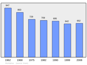
Onderstaande figuur toont het verloop van het inwonertal (bron: INSEE-tellingen).
Externe links
- (fr) Statistische informatie op de website van INSEE
Mediabestanden
Zie de categorie Monbahus van Wikimedia Commons voor mediabestanden over dit onderwerp.


