Sundarijal
| gaun wikas samiti | |||
 The waterfall Sweet Sixteen, Sundarijal, Nepal | |||
| Państwo |
| ||
|---|---|---|---|
| Strefa | Bagmati | ||
| Dystrykt | Katmandu | ||
| Populacja (2001) • liczba ludności |
| ||
Położenie na mapie Nepalu  | |||
 27°48′N 85°25′E/27,800000 85,416667 27°48′N 85°25′E/27,800000 85,416667 | |||
| |||


Sundarijal (nep. सुन्दरीजल) – najniższa szczeblem wiejska jednostka terytorialna (gaun wikas samiti) w środkowej części Nepalu w strefie Bagmati w dystrykcie Katmandu[2]. Według nepalskiego spisu powszechnego z 2001 roku liczył on 491 gospodarstw domowych i 2499 mieszkańców (1229 kobiet i 1270 mężczyzn)[3].
Galeria
-
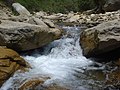 Rzeka Bagmati w Sundarijal
 -
 Shivapuri Nagarjun National Park
 -
 Uprawa ryżu w Sundarijal
 -
 Bilbil białolicy w Sundarijal
 -
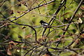 Sroczek zmienny w Sundarijal


Przypisy
- ↑ List of Village Development Committees prior to restucturing [online], Nepal Government – Ministry of Federal Affairs and General Administration [dostęp 2019-07-14] .
- ↑ Index of Geographical names of Nepal - Central Development Region - Volume II. National Geographic Information Infrastructure Programme. [dostęp 2010-09-27]. (ang.).
- ↑ VDC’s population. National Association of Village Development Committees in Nepal (NAVIN). [dostęp 2020-10-12]. (ang.).
- p
- d
- e
Dystrykt Katmandu
- Stolica dystryktu: Katmandu
| Jednostki administracyjne dystryktu |
|
|---|


