Bow Peak
Mountain peak in Banff National Park, Alberta, Canada


Bow Peak
Location of Bow Peak in Alberta
Show map of Alberta
Bow Peak
Bow Peak (Canada)
Show map of CanadaBow Peak is a 2,840-metre (9,320-foot) mountain summit located in the Bow River valley of Banff National Park, in the Canadian Rockies of Alberta, Canada. Its nearest higher peak is Crowfoot Mountain, 2.11 km (1.31 mi) to the east.[1] Bow Peak is situated north of Hector Lake, southeast of Bow Lake, and can be seen from the Icefields Parkway. Although not of remarkable elevation, the mountain is a conspicuous landmark and visible from as far away as the Lake Louise area.[3] Its position in the Waputik Mountains provides magnificent views from the summit.[4][1]
History
Bow Peak was named in 1922 for its proximity to the headwaters of the Bow River which was known by the Cree as "The place from which bows are taken."[3] The mountain's name became official in 1924 by the Geographical Names Board of Canada.[2]
Geology
Like other mountains in Banff Park, Bow Peak is composed of sedimentary rock laid down during the Precambrian to Jurassic periods.[5] Formed in shallow seas, this sedimentary rock was pushed east and over the top of younger rock during the Laramide orogeny.[6]
Climate
Based on the Köppen climate classification, Bow Peak is located in a subarctic climate zone with cold, snowy winters, and mild summers.[7] Temperatures can drop below −20 °C with wind chill factors below −30 °C. Precipitation runoff from Bow Peak drains into the Bow River which is a tributary of the Saskatchewan River.
Gallery
-
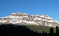 The broad east face of Bow Peak
 -
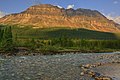 East face
 -
 Bow Peak winter scene
 -
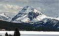
 South aspect of Bow Peak (left) from Icefields Parkway
 -
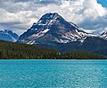 Bow Peak and Bow Lake


See also
References
- ^ a b c d e "Bow Peak, Alberta". Peakbagger.com. Retrieved 2019-10-09.
- ^ a b c "Bow Peak". Geographical Names Data Base. Natural Resources Canada. Retrieved 2018-10-24.
- ^ a b "Bow Peak". cdnrockiesdatabases.ca. Retrieved 2021-07-27.
- ^ Copeland, Kathy; Copeland, Craig (2004). Don't Waste Your Time in the Canadian Rockies. Hikingcamping.com. ISBN 0-9689419-7-4.
- ^ Belyea, Helen R. (1960). The Story of the Mountains in Banff National Park (PDF). parkscanadahistory.com (Report). Ottawa: Geological Survey of Canada. Archived (PDF) from the original on 2015-10-02. Retrieved 2019-09-13.
- ^ Gadd, Ben (2008). Geology of the Rocky Mountains and Columbias.
- ^ Peel, M. C.; Finlayson, B. L.; McMahon, T. A. (2007). "Updated world map of the Köppen−Geiger climate classification". Hydrol. Earth Syst. Sci. 11: 1633–1644. ISSN 1027-5606.
External links
- Parks Canada web site: Banff National Park
- Andromache, Hector, Bow, Crowfoot panorama: Flickr photo
- PBase photo: Bow Peak - Icefields Parkway
- Weather: Bow Peak
Places adjacent to Bow Peak | ||||||||||||||||
|---|---|---|---|---|---|---|---|---|---|---|---|---|---|---|---|---|
| ||||||||||||||||


- v
- t
- e
- Ball
- Bare
- Beaverfoot
- Blue
- Bow
- Crowsnest
- Elk
- Fairholme
- Fiddle
- Flathead
- Foothills
- High Rock
- Kananaskis
- Livingstone
- Lizard
- Maligne
- Massive
- Misty
- Morrissey
- Palliser
- President
- Queen Elizabeth
- Rainbow
- Ram
- Sawback
- Sentinel
- Slate
- South Jasper
- Sundance
- Terminal
- Tower of London
- Vermilion
- Victoria Cross
- Waputik
- Winston Churchill
- Continental Ranges
- Hart Ranges
- Muskwa Ranges
- Alberta
- Andromeda
- Assiniboine
- Athabasca
- Brazeau
- Bryce
- Cascade
- Castle
- Castleguard
- Clemenceau
- Columbia
- Cory
- Edith Cavell
- Forbes
- Hector
- Hosmer
- Hungabee
- Joffre
- Kitchener
- Lyell
- Heart
- Pilot
- Pyramid
- Resplendent
- Robson
- Rundle
- Sarbach
- Saskatchewan
- Smythe
- Snow Dome
- Stanley Peak
- Sulphur
- Temple
- Three Sisters
- Trinity
- Twin
- Ulysses
- Unnamed Alberta–BC mountain (formerly Mount Pétain)
- Whymper
see List of rivers of the Canadian Rockies and Category:Rivers of the Canadian Rockies
- Mountain Stoney
- Mountain Metis
| International | |
|---|---|
| National |
|
| Provincial (AB) |
|
| Provincial (BC) |
- See also
- Geography portal
- Canada portal


