Dolomite Peak
Mountain in Banff NP, Alberta, Canada


Dolomite Peak
Location of Dolomite Peak in Alberta
Show map of Alberta
Dolomite Peak
Dolomite Peak (Canada)
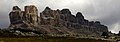
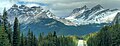
Show map of CanadaDolomite Peak is a 2,998-metre (9,836-foot) mountain summit located in the Bow River valley of Banff National Park, in the Canadian Rockies of Alberta, Canada. Its nearest higher peak is Cirque Peak, 3.98 km (2.47 mi) to the northwest.[2] Dolomite Peak can be seen from the Icefields Parkway with its distinctive crags and colorful towers that are a mixture of dolomite and limestone. Dolomite is rare in the Rockies and is stronger than limestone.[1]
History
Dolomite Peak was named in 1897 by Charles E. Fay, Norman Collie, and Charles Thompson for its resemblance to the Dolomites of the Italian Alps.[1] The mountain's name became official in 1924 by the Geographical Names Board of Canada.[3] The first ascent of Dolomite Peak was made in 1930 by J. Monroe Thorington, with Peter Kaufmann (as guide).[1]
Geology
Like other mountains in Banff Park, Dolomite Peak is composed of sedimentary rock laid down during the Precambrian to Jurassic periods.[5] Formed in shallow seas, this sedimentary rock was pushed east and over the top of younger rock during the Laramide orogeny.[6]
Climate
Based on the Köppen climate classification, Dolomite Peak is located in a subarctic climate with cold, snowy winters, and mild summers.[7] Temperatures can drop below −20 °C with wind chill factors below −30 °C. Precipitation runoff from Dolomite Peak drains into the Bow River which is a tributary of the Saskatchewan River. The months July through September offer the most favorable weather for viewing and climbing this peak.
Gallery
-
 Dolomite Peak, west aspect
 -
 Dolomite Peak close up
 -
 Dolomite Peak seen from northbound Icefields Parkway
 -
 Dolomite Peak (left) and Watermelon Peak S2 (2929 m) to right


References
- ^ a b c d e "Dolomite Peak". cdnrockiesdatabases.ca. Retrieved 2019-10-08.
- ^ a b c "Dolomite Peak". Peakbagger.com. Retrieved 2019-10-08.
- ^ a b c "Dolomite Peak". Geographical Names Data Base. Natural Resources Canada. Retrieved 2018-10-24.
- ^ Kane, Alan (1999). "Dolomite Peak". Scrambles in the Canadian Rockies. Calgary: Rocky Mountain Books. pp. 294–296. ISBN 0-921102-67-4.
- ^ Belyea, Helen R. (1960). The Story of the Mountains in Banff National Park (PDF). parkscanadahistory.com (Report). Ottawa: Geological Survey of Canada. Archived (PDF) from the original on 2015-10-02. Retrieved 2019-09-13.
- ^ Gadd, Ben (2008). Geology of the Rocky Mountains and Columbias.
- ^ Peel, M. C.; Finlayson, B. L.; McMahon, T. A. (2007). "Updated world map of the Köppen−Geiger climate classification". Hydrol. Earth Syst. Sci. 11 (5): 1633–1644. Bibcode:2007HESS...11.1633P. doi:10.5194/hess-11-1633-2007. ISSN 1027-5606. S2CID 9654551.
See also
External links
- Weather forecast: Dolomite Peak
- Parks Canada web site: Banff National Park
Places adjacent to Dolomite Peak | ||||||||||||||||
|---|---|---|---|---|---|---|---|---|---|---|---|---|---|---|---|---|
| ||||||||||||||||


- v
- t
- e
- Ball
- Bare
- Beaverfoot
- Blue
- Bow
- Crowsnest
- Elk
- Fairholme
- Fiddle
- Flathead
- Foothills
- High Rock
- Kananaskis
- Livingstone
- Lizard
- Maligne
- Massive
- Misty
- Morrissey
- Palliser
- President
- Queen Elizabeth
- Rainbow
- Ram
- Sawback
- Sentinel
- Slate
- South Jasper
- Sundance
- Terminal
- Tower of London
- Vermilion
- Victoria Cross
- Waputik
- Winston Churchill
- Continental Ranges
- Hart Ranges
- Muskwa Ranges
- Alberta
- Andromeda
- Assiniboine
- Athabasca
- Brazeau
- Bryce
- Cascade
- Castle
- Castleguard
- Clemenceau
- Columbia
- Cory
- Edith Cavell
- Forbes
- Hector
- Hosmer
- Hungabee
- Joffre
- Kitchener
- Lyell
- Heart
- Pilot
- Pyramid
- Resplendent
- Robson
- Rundle
- Sarbach
- Saskatchewan
- Smythe
- Snow Dome
- Stanley Peak
- Sulphur
- Temple
- Three Sisters
- Trinity
- Twin
- Ulysses
- Unnamed Alberta–BC mountain (formerly Mount Pétain)
- Whymper
see List of rivers of the Canadian Rockies and Category:Rivers of the Canadian Rockies
- Mountain Stoney
- Mountain Metis
| International | |
|---|---|
| National |
|
| Provincial (AB) |
|
| Provincial (BC) |
- See also
- Geography portal
- Canada portal


