Brighams Tomb


Brighams Tomb
Location in Utah
Show map of Utah
Brighams Tomb
Brighams Tomb (the United States)
Show map of the United StatesSan Juan County, Utah, U.S.
Brighams Tomb is a 6,739-foot-elevation (2,054-meter) summit in San Juan County, Utah, United States.[1]
Description
Brighams Tomb is situated six miles (9.7 km) northeast of Oljato–Monument Valley, Utah, on Navajo Nation land. It is an iconic landform of Monument Valley and can be seen from Highway 163. Precipitation runoff from this landform's slopes drains into the San Juan River drainage basin.[3] Topographic relief is significant as the summit rises 1,000 feet (305 meters) above the surrounding terrain in 0.25 mile (0.4 km). The mountain's name refers to Brigham Young,[4] the first governor of the Utah Territory. This landform's toponym was officially adopted/revised in 1988 by the United States Board on Geographic Names after having been officially named "Saddleback" from 1964 through 1987.[1][5] Some older maps will still show the Saddleback name.
Geology
Brighams Tomb is composed of three principal strata. The bottom layer is slope-forming Organ Rock Shale, the next stratum is cliff-forming De Chelly Sandstone, and the upper layer is Moenkopi Formation capped by Shinarump Conglomerate. The rock ranges in age from Permian at the bottom to Late Triassic at the top. The buttes and mesas of Monument Valley are the result of the Organ Rock Shale being more easily eroded than the overlaying sandstone.[6]
Climate
Spring and fall are the most favorable seasons to visit Brighams Tomb. According to the Köppen climate classification system, it is located in a semi-arid climate zone with cold winters and hot summers. Summers average 54 days above 90 °F (32 °C) annually, and highs rarely exceed 100 °F (38 °C). Summer nights are comfortably cool, and temperatures drop quickly after sunset. Winters are cold, but daytime highs are usually above freezing. Winter temperatures below 0 °F (−18 °C) are uncommon, though possible. This desert climate receives less than 10 inches (250 millimeters) of annual rainfall, and snowfall is generally light during the winter.[7]
Gallery
-
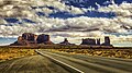
 Brighams Tomb to the right, looking southwest from Highway 163.
Forrest Gump was here. (culmination of cross-country running scene) -
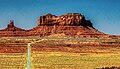
 Brighams Tomb to the right
 -
 Brighams Tomb to the right
 -
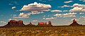
 Southwest aspect, with King-on-his-Throne to right
 -
 Brighams Tomb to the right
 -
 Brighams Tomb to the right
 -
 Brighams Tomb to the right
 -
 Northeast aspect
 -
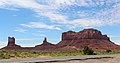
 South aspect of Brighams Tomb (centered) and Castle Rock (right) viewed from North Window Overlook
 -
 Brighams Tomb to the left
 -
 Brighams Tomb to the left
 -
 North aspect


See also
References
- ^ a b c d "Brighams Tomb". Geographic Names Information System. United States Geological Survey, United States Department of the Interior. Retrieved 2024-08-24.
- ^ a b c d "Brighams Tomb - 6,725' UT". listsofjohn.com. Retrieved 2024-08-24.
- ^ a b "Brighams Tomb, Utah". Peakbagger.com. Retrieved 2024-08-24.
- ^ Monument Valley, City of Aztec, aztecnm.com, Retrieved 2024-08-24.
- ^ Decisions on Geographic Names in the United States, Decision List No. 8803, 1988, p. 12.
- ^ Monument Valley, Arizona, Arizona Geological Survey, Retrieved 2024-08-24.
- ^ Climate Summary for Kayenta, Arizona
External links
- Weather forecast: Brighams Tomb
- West aspect of Brighams Tomb (photo): Flickr
- v
- t
- e
Places adjacent to Brighams Tomb
| Setting Hen | Highway 163 | Eagle Rock Wash |
 | ||
| Eagle Mesa |  Brighams Tomb Brighams Tomb | Eagle Rock Wash |
 | King-on-his-Throne | |
| Oljato–Monument Valley | Sentinel Mesa | Castle Rock |
Portals:
 Geography
 Geology
 Utah
Utah


