Setting Hen


Setting Hen
Location in Utah
Show map of Utah
Setting Hen
Setting Hen (the United States)
Show map of the United StatesSan Juan County, Utah, U.S.
Setting Hen is a 6,293-foot-elevation (1,918-meter) summit in San Juan County, Utah, United States.[1]
Description
Setting Hen is situated 5.5 miles (8.9 km) northeast of Oljato–Monument Valley, Utah, on Navajo Nation land. It is an iconic landform of Monument Valley and can be seen from Highway 163. Precipitation runoff from this butte's slopes drains into the San Juan River drainage basin.[3] Topographic relief is significant as the summit rises 600 feet (183 meters) above surrounding terrain in 0.25 mile (0.4 km). The nearest higher neighbor is Eagle Mesa, 0.71 miles (1.14 km) to the southwest.[2] This landform's toponym has been officially adopted by the United States Board on Geographic Names,[1] and the descriptive name refers to the profile resembling a sitting hen when viewed from the southeast.[4] Setting Hen should not be confused with another butte named Setting Hen Butte within the same county but further northeast at Valley of the Gods.
Geology
Setting Hen is a butte composed of two principal strata. The bottom layer is Organ Rock Shale and the upper stratum is cliff-forming De Chelly Sandstone. The rock was deposited during the Permian period. The buttes and mesas of Monument Valley are the result of the Organ Rock Shale being more easily eroded than the overlaying sandstone.[5]
Climate
Spring and fall are the most favorable seasons to visit Setting Hen. According to the Köppen climate classification system, it is located in a semi-arid climate zone with cold winters and hot summers. Summers average 54 days above 90 °F (32 °C) annually, and highs rarely exceed 100 °F (38 °C). Summer nights are comfortably cool, and temperatures drop quickly after sunset. Winters are cold, but daytime highs are usually above freezing. Winter temperatures below 0 °F (−18 °C) are uncommon, though possible. This desert climate receives less than 10 inches (250 millimeters) of annual rainfall, and snowfall is generally light during the winter.[6]
See also
Gallery
-
 South aspect, with a dusting of autumn snow
 -
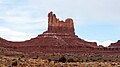
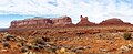 Eagle Mesa (left) and Setting Hen viewed from the south.
 -
 Eagle Mesa (left), Setting Hen (right)
 -
 Aerial view of Setting Hen (right) with Eagle Mesa (center left)
 -
 Eagle Mesa (left), Setting Hen (right)
 -
 Setting Hen centered
 -

-
 Aerial view


References
- ^ a b c d "Setting Hen". Geographic Names Information System. United States Geological Survey, United States Department of the Interior. Retrieved 2024-08-27.
- ^ a b c d "Setting Hen - 6,340' UT". listsofjohn.com. Retrieved 2024-08-27.
- ^ a b "Setting Hen, Utah". Peakbagger.com. Retrieved 2024-08-27.
- ^ Monument Valley, City of Aztec, aztecnm.com, Retrieved 2024-08-27.
- ^ Monument Valley, Arizona, Arizona Geological Survey, Retrieved 2024-08-22.
- ^ Climate Summary for Kayenta, Arizona
External links
- Weather forecast: Setting Hen
- v
- t
- e
Places adjacent to Setting Hen
| Train Rock Wash | Train Rock Wash | Eagle Rock Wash |
 | ||
| Eagle Mesa |  Setting Hen Setting Hen | Brighams Tomb |
 | ||
| Eagle Mesa | Highway 163 | Castle Rock |
Portals:
 Geography
 Geology
 Utah
Utah


