Etten, Netherlands
Village in Gelderland, Netherlands
51°55′0″N 6°20′11″E / 51.91667°N 6.33639°E / 51.91667; 6.33639[1]
[2]
(2021)[1]
7075[1]
Etten is a village in the Dutch province of Gelderland. It is located in the municipality of Oude IJsselstreek, 7 km southeast of Doetinchem.
Etten was a separate municipality until 1818, when it was merged with Gendringen.[3]
History
It was first mentioned around 1200 as de Ettene. The etymology in clear.[4] The village started on a river dune along the Oude IJssel. The Dutch Reformed Church dates from the 15th century. The tower has 11th century elements.[5] Castle Schuylenburgh was a medieval castle. It was bombed twice during World War II, and later demolished.[6] In 1840, it was home to 292 people.[7]
Gallery
-
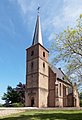 Etten, reformed church
 -
 Castle Schuylenburgh
 -
 House in Etten


References
- ^ a b c "Kerncijfers wijken en buurten 2021". Central Bureau of Statistics. Retrieved 24 March 2022.
two entries
- ^ "Postcodetool for 7075AA". Actueel Hoogtebestand Nederland (in Dutch). Het Waterschapshuis. Retrieved 24 March 2022.
- ^ Ad van der Meer and Onno Boonstra, "Repertorium van Nederlandse gemeenten", KNAW, 2006. "KNAW > Publicaties > Detailpagina". Archived from the original on February 20, 2007. Retrieved December 3, 2009.
- ^ "Etten - (geografische naam)". Etymologiebank (in Dutch). Retrieved 24 March 2022.
1105 document was a forgery
- ^ Ronald Stenvert & Sabine Broekhoven (2000). Etten (in Dutch). Zwolle: Waanders. ISBN 90-400-9406-3. Retrieved 24 March 2022.
- ^ "Het mysterieuze kasteel in Terborg dat nu toch eindelijk 'open huis' houdt". 75 Jaarvrijheid (in Dutch). Retrieved 24 March 2022.
- ^ "Etten". Plaatsengids (in Dutch). Retrieved 24 March 2022.
- v
- t
- e
Populated places in the municipality of Oude IJsselstreek
- Bontebrug
- Breedenbroek
- Etten
- Gendringen
- Megchelen
- Netterden
- Silvolde
- Sinderen
- Varsselder
- Varsseveld
- Westendorp [nl]
 | This Gelderland location article is a stub. You can help Wikipedia by expanding it. |
- v
- t
- e


