Fleet Pond
| Site of Special Scientific Interest | |
 | |
| Location | Hampshire |
|---|---|
| Grid reference | SU 821 550[1] |
| Interest | Biological |
| Area | 48.3 hectares (119 acres)[1] |
| Notification | 1984[1] |
| Location map | Magic Map |
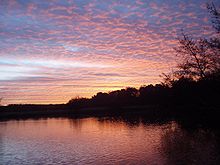
Fleet Pond is a 48.3-hectare (119-acre) biological Site of Special Scientific Interest in Fleet in Hampshire.[1][2] It is also a Local Nature Reserve.[3][4]
Geography and Biodiversity
This large and shallow lake, fed by Fleet Brook,[5] is surrounded by reed beds, alder carr and oak and birch woodland. The lake has a rich aquatic flora and fauna, including large populations of reed warblers and other wetland birds.[6]
The pond has varied habitats surrounding it, including heathland, marsh, reedbed and woodland.[7]
History
The pond is first documented in 1324, when there were two ponds which were used as a fishery. In medieval times, "pond" always referred to a man-made structure, whereas "lake" referred to a natural feature, and so it is likely that the ponds were created by raising banks at the northern edge. From 1491, the Prior of Winchester leased the ponds to the occupier of Fleet Farm, in exchange for one hundred fresh fish a year, delivered to Winchester. When the lease was renewed in 1833, it was noted that there was now only one pond. The second pond was probably near Ancells Farm. Shortly afterwards, the London and Southampton Railway bought the pond for £50 as it stood in the way of their line, and built an embankment across the northern end. They appreciated its potential as a tourist destination, and opened Fleet Pond Halt so that day trippers could visit it. Much of the surrounding area became a military training ground in 1854, and as part of that training, soldiers built a 470-yard (430 m) trestle bridge across it in 1885. During the Second World War, the pond was drained, to make the area less visible to enemy aircraft, but it was refilled in 1947, and planted with reeds. The pond became one of the first SSSIs in Hampshire in 1951, and under the Wildlife and Countryside Act 1981, duly re-registered, but to omit the portion north of the embankment. Hart District Council bought the pond and surrounding heath in 1972, after the army dubbed it redundant, and since 1976 has worked with the Fleet Pond Society to create a Local nature reserve. They have installed two bridges to create a circular walk around the pond.[8]
Wikimedia Commons has media related to Fleet Pond.
References
- ^ a b c d "Designated Sites View: Fleet Pond". Sites of Special Scientific Interest. Natural England. Retrieved 10 May 2020.
- ^ "Map of Fleet Pond". Sites of Special Scientific Interest. Natural England. Retrieved 10 May 2020.
- ^ "Fleet Pond". Local Nature Reserves. Natural England.
- ^ "Map of Fleet Pond". Local Nature Reserves. Natural England.
- ^ Ordnance Survey, 1:2500 map
- ^ "Fleet Pond citation" (PDF). Sites of Special Scientific Interest. Natural England. Retrieved 10 May 2020.
- ^ "Fleet Pond". Hart District Council. Archived from the original on 24 March 2016.
- ^ Society (2016). "History". Fleet Pond Society. Archived from the original on 7 July 2016.
External links
- Fleet Pond Society
51°17′18″N 0°49′32″W / 51.28824°N 0.82550°W / 51.28824; -0.82550
- v
- t
- e

- Alresford Pond
- Ashford Hill Woods and Meadows
- Avon Valley (Bickton to Christchurch)
- Baddesley Common
- Basingstoke Canal
- Beacon Hill, Warnford
- Bentley Station Meadow
- Bere Mill Meadows
- Binswood
- Blackwater Valley
- Botley Wood and Everett's and Mushes Copses
- Boulsbury Wood
- Bourley and Long Valley
- Bramshill
- Bramshott and Ludshott Commons
- Bransbury Common
- Breamore Marsh
- Brickworth Down and Dean Hill
- Brockley Warren
- Broughton Down
- Browndown
- Broxhead and Kingsley Commons
- Burghclere Beacon
- Burton Common
- Butser Hill
- Butter Wood
- Castle Bottom to Yateley and Hawley Commons
- Catherington Down
- Cheesefoot Head
- Chichester Harbour
- Chilbolton Common
- Coombe Wood and The Lythe
- Coulters Dean
- Crab Wood
- Danebury Hill
- Dibden Bay
- East Aston Common
- Ebblake Bog
- Eelmoor Marsh
- Eling and Bury Marshes
- Fleet Pond
- Fletchwood Meadows
- Foxlease and Ancells Meadows
- Galley Down Wood
- Gilkicker Lagoon
- Greywell Fen
- Greywell Tunnel
- Hazeley Heath
- Highclere Park
- Hook Common and Bartley Heath
- Hook Heath Meadows
- Hurst Castle and Lymington River Estuary
- Hythe to Calshot Marshes
- Itchen Navigation
- Ladle Hill
- Langstone Harbour
- Lee-on-The Solent to Itchen Estuary
- Lincegrove and Hackett's Marshes
- Lower Test Valley
- Lye Heath Marsh
- Lymington River
- Lymington River Reedbeds
- Mapledurwell Fen
- Martin and Tidpit Downs
- Micheldever Spoil Heaps
- Moorgreen Meadows
- The Moors, Bishop's Waltham
- Mottisfont Bats
- The New Forest
- Noar Hill
- Norley Copse and Meadow
- North Solent
- Odiham Common with Bagwell Green and Shaw
- Old Burghclere Lime Quarry
- Old Winchester Hill
- Pamber Forest and Silchester Common
- Peake Wood
- Poors Common
- Porton Down
- Portsdown
- Portsmouth Harbour
- Quarley Hill Fort
- Ratlake Meadows
- River Avon System
- River Itchen
- River Test
- Ron Ward's Meadow With Tadley Pastures
- Roydon Woods
- Rushmore and Conholt Downs
- Selborne Common
- Shortheath Common
- Sidley Wood
- Sinah Common
- Southampton Common
- Sowley Pond
- St. Catherine's Hill
- Stockbridge Common Marsh
- Stockbridge Down
- Stockbridge Fen
- Titchfield Haven
- Toyd Down and Quarry
- Trodds Copse
- Upper Greensand Hangers: Empshott to Hawkley
- Upper Greensand Hangers: Wyck to Wheatley
- Upper Hamble Estuary and Woods
- Waltham Chase Meadows
- Warblington Meadow
- Warnborough Green
- Wealden Edge Hangers
- West Minley Meadow
- West Woodhay Down
- Wick Wood and Worldham Hangers
- The Wild Grounds
- Woolmer Forest
- Butser Hill
- Downend Chalk Pit
- Dunbridge Pit
- Duncroft Farm Pit
- Heath Brow
- Highcliffe to Milford Cliffs
- Hurst Castle and Lymington River Estuary
- Lee-on-The Solent to Itchen Estuary
- Lymington River
- The New Forest
- North Solent
| ||||||||||||
|---|---|---|---|---|---|---|---|---|---|---|---|---|
| Main rivers main tributaries & sub-tributaries |
|  | ||||||||||
| Canals and navigations | ||||||||||||
| Ordinary watercourses | ||||||||||||
| Lakes, ponds and wetlands | ||||||||||||
| Coast | ||||||||||||
Categories: Rivers, Canals | ||||||||||||
| Authority control databases: National |
|
|---|


