Highcliffe to Milford Cliffs
UK Site of Special Scientific Interest
| Site of Special Scientific Interest | |
 | |
| Location | Dorset Hampshire |
|---|---|
| Grid reference | SZ 239 926[1] |
| Interest | Geological |
| Area | 110.1 hectares (272 acres)[1] |
| Notification | 1991[1] |
| Location map | Magic Map |
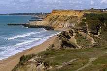
Highcliffe to Milford Cliffs is a 110.1-hectare (272-acre) geological Site of Special Scientific Interest which stretches along the south coast of England from Christchurch in Dorset to Milford on Seain Hampshire.[1][2] It includes several Geological Conservation Review sites.[3][4][5][6][7]
This site stretches along the cliffs of Christchurch Bay for 9-kilometre (5.6-mile). It exposes the fossil rich strata of the Barton Beds and Headon Beds, dating to the Eocene epoch around 40 million years ago, and is the type locality for many species of fauna and flora. The Barton Beds are capped by Pleistocene gravels which are rich in Paleolithic artefacts.[8]
References
- ^ a b c d "Designated Sites View: Highcliffe to Milford Cliffs". Sites of Special Scientific Interest. Natural England. Retrieved 12 May 2020.
- ^ "Map of Highcliffe to Milford Cliffs". Sites of Special Scientific Interest. Natural England. Retrieved 12 May 2020.
- ^ "Hordle (Aves)". Geological Conservation Review. Joint Nature Conservation Committee. Retrieved 21 April 2020.[permanent dead link]
- ^ "Hordle - Beacon Cliffs (Tertiary Palaeobotany)". Geological Conservation Review. Joint Nature Conservation Committee. Retrieved 21 April 2020.[permanent dead link]
- ^ "Hordle Cliff (Tertiary Mammalia)". Geological Conservation Review. Joint Nature Conservation Committee. Retrieved 21 April 2020.[permanent dead link]
- ^ "Hordle Cliff (Tertiary Reptilia)". Geological Conservation Review. Joint Nature Conservation Committee. Retrieved 21 April 2020.[permanent dead link]
- ^ "Paddy's Gap (Tertiary Palaeobotany)". Geological Conservation Review. Joint Nature Conservation Committee. Retrieved 21 April 2020.[permanent dead link]
- ^ "Highcliffe to Milford Cliffs citation" (PDF). Sites of Special Scientific Interest. Natural England. Retrieved 12 May 2020.
Wikimedia Commons has media related to Highcliffe to Milford Cliffs.
50°43′59″N 1°39′47″W / 50.733°N 1.663°W / 50.733; -1.663
- v
- t
- e

- Alresford Pond
- Ashford Hill Woods and Meadows
- Avon Valley (Bickton to Christchurch)
- Baddesley Common
- Basingstoke Canal
- Beacon Hill, Warnford
- Bentley Station Meadow
- Bere Mill Meadows
- Binswood
- Blackwater Valley
- Botley Wood and Everett's and Mushes Copses
- Boulsbury Wood
- Bourley and Long Valley
- Bramshill
- Bramshott and Ludshott Commons
- Bransbury Common
- Breamore Marsh
- Brickworth Down and Dean Hill
- Brockley Warren
- Broughton Down
- Browndown
- Broxhead and Kingsley Commons
- Burghclere Beacon
- Burton Common
- Butser Hill
- Butter Wood
- Castle Bottom to Yateley and Hawley Commons
- Catherington Down
- Cheesefoot Head
- Chichester Harbour
- Chilbolton Common
- Coombe Wood and The Lythe
- Coulters Dean
- Crab Wood
- Danebury Hill
- Dibden Bay
- East Aston Common
- Ebblake Bog
- Eelmoor Marsh
- Eling and Bury Marshes
- Fleet Pond
- Fletchwood Meadows
- Foxlease and Ancells Meadows
- Galley Down Wood
- Gilkicker Lagoon
- Greywell Fen
- Greywell Tunnel
- Hazeley Heath
- Highclere Park
- Hook Common and Bartley Heath
- Hook Heath Meadows
- Hurst Castle and Lymington River Estuary
- Hythe to Calshot Marshes
- Itchen Navigation
- Ladle Hill
- Langstone Harbour
- Lee-on-The Solent to Itchen Estuary
- Lincegrove and Hackett's Marshes
- Lower Test Valley
- Lye Heath Marsh
- Lymington River
- Lymington River Reedbeds
- Mapledurwell Fen
- Martin and Tidpit Downs
- Micheldever Spoil Heaps
- Moorgreen Meadows
- The Moors, Bishop's Waltham
- Mottisfont Bats
- The New Forest
- Noar Hill
- Norley Copse and Meadow
- North Solent
- Odiham Common with Bagwell Green and Shaw
- Old Burghclere Lime Quarry
- Old Winchester Hill
- Pamber Forest and Silchester Common
- Peake Wood
- Poors Common
- Porton Down
- Portsdown
- Portsmouth Harbour
- Quarley Hill Fort
- Ratlake Meadows
- River Avon System
- River Itchen
- River Test
- Ron Ward's Meadow With Tadley Pastures
- Roydon Woods
- Rushmore and Conholt Downs
- Selborne Common
- Shortheath Common
- Sidley Wood
- Sinah Common
- Southampton Common
- Sowley Pond
- St. Catherine's Hill
- Stockbridge Common Marsh
- Stockbridge Down
- Stockbridge Fen
- Titchfield Haven
- Toyd Down and Quarry
- Trodds Copse
- Upper Greensand Hangers: Empshott to Hawkley
- Upper Greensand Hangers: Wyck to Wheatley
- Upper Hamble Estuary and Woods
- Waltham Chase Meadows
- Warblington Meadow
- Warnborough Green
- Wealden Edge Hangers
- West Minley Meadow
- West Woodhay Down
- Wick Wood and Worldham Hangers
- The Wild Grounds
- Woolmer Forest
- Butser Hill
- Downend Chalk Pit
- Dunbridge Pit
- Duncroft Farm Pit
- Heath Brow
- Highcliffe to Milford Cliffs
- Hurst Castle and Lymington River Estuary
- Lee-on-The Solent to Itchen Estuary
- Lymington River
- The New Forest
- North Solent


