List of listed buildings in Cargill, Perth and Kinross
This is a list of listed buildings in the parish of Cargill in Perth and Kinross, Scotland.
Map all coordinates using OpenStreetMap
Download coordinates as:
- KML
- GPX (all coordinates)
- GPX (primary coordinates)
- GPX (secondary coordinates)
List
| Name | Location | Date Listed | Grid Ref. [note 1] | Geo-coordinates | Notes | LB Number [note 2] | Image |
|---|---|---|---|---|---|---|---|
| Cargill, Old Churchyard | 56°31′02″N 3°22′59″W / 56.517289°N 3.382925°W / 56.517289; -3.382925 (Cargill, Old Churchyard) | Category C(S) | 5468 |  Upload Photo | |||
| Cargill Manse, Sundial | 56°30′56″N 3°23′04″W / 56.515519°N 3.384567°W / 56.515519; -3.384567 (Cargill Manse, Sundial) | Category C(S) | 5471 | Upload Photo | |||
| Balholmie House | 56°30′38″N 3°23′11″W / 56.510601°N 3.3865°W / 56.510601; -3.3865 (Balholmie House) | Category C(S) | 5476 | Upload Photo | |||
| Stobhall New Library | 56°29′35″N 3°24′42″W / 56.493103°N 3.411573°W / 56.493103; -3.411573 (Stobhall New Library) | Category A | 5477 | Upload Photo | |||
| Stobhall, Sundial In Formal Garden To N Of Dowery House | 56°29′37″N 3°24′40″W / 56.493646°N 3.411187°W / 56.493646; -3.411187 (Stobhall, Sundial In Formal Garden To N Of Dowery House) | Category A | 5479 | Upload Photo | |||
| Stobhall, Sundial In Octagonal Garden To Ne Of Dowery House | 56°29′40″N 3°24′38″W / 56.494354°N 3.410564°W / 56.494354; -3.410564 (Stobhall, Sundial In Octagonal Garden To Ne Of Dowery House) | Category A | 79 | Upload Photo | |||
| Brunty Mill Bridge Over Coupar Burn | 56°31′44″N 3°18′25″W / 56.528904°N 3.306838°W / 56.528904; -3.306838 (Brunty Mill Bridge Over Coupar Burn) | Category B | 5449 | Upload Photo | |||
| Bridge On A 94 Over Coupar Burn, Near Damhead, Woodside | 56°31′47″N 3°17′25″W / 56.529698°N 3.290217°W / 56.529698; -3.290217 (Bridge On A 94 Over Coupar Burn, Near Damhead, Woodside) | Category C(S) | 5452 | Upload Photo | |||
| Cargill, Monument To Thomsons And Macgregors Of Wolfhill And Newbigging, In Old Churchyard | 56°31′02″N 3°22′59″W / 56.517289°N 3.382925°W / 56.517289; -3.382925 (Cargill, Monument To Thomsons And Macgregors Of Wolfhill And Newbigging, In Old Churchyard) | Category B | 5469 | Upload Photo | |||
| Stobhall Old Bridge | 56°29′39″N 3°24′37″W / 56.49407°N 3.41031°W / 56.49407; -3.41031 (Stobhall Old Bridge) | Category C(S) | 5481 | Upload Photo | |||
| Cargill Church | 56°31′00″N 3°22′53″W / 56.516641°N 3.381454°W / 56.516641; -3.381454 (Cargill Church) | Category B | 5467 | Upload Photo | |||
| Balholmie, Sundial In Garden Of | 56°30′40″N 3°23′11″W / 56.511122°N 3.386454°W / 56.511122; -3.386454 (Balholmie, Sundial In Garden Of) | Category B | 5472 | Upload Photo | |||
| Burrelton, Stevenson's Building, High Street | 56°31′09″N 3°18′05″W / 56.519231°N 3.301336°W / 56.519231; -3.301336 (Burrelton, Stevenson's Building, High Street) | Category C(S) | 5451 | Upload Photo | |||
| Cargill, Wright Vault In Cargill Old Churchyard | 56°31′02″N 3°22′59″W / 56.517289°N 3.382925°W / 56.517289; -3.382925 (Cargill, Wright Vault In Cargill Old Churchyard) | Category C(S) | 5470 | Upload Photo | |||
| Stobhall, Chapel Block | 56°29′36″N 3°24′41″W / 56.493213°N 3.411415°W / 56.493213; -3.411415 (Stobhall, Chapel Block) | Category A | 5473 | 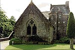 Upload another image | |||
| Stobhall, Dowery House | 56°29′36″N 3°24′40″W / 56.493394°N 3.411243°W / 56.493394; -3.411243 (Stobhall, Dowery House) | Category A | 5475 | Upload another image | |||
| Stobhall, Caretaker's House And Garages | 56°29′38″N 3°24′40″W / 56.493936°N 3.411003°W / 56.493936; -3.411003 (Stobhall, Caretaker's House And Garages) | Category C(S) | 5480 | Upload Photo | |||
| Stobhall, Folly | 56°29′41″N 3°24′38″W / 56.494659°N 3.410657°W / 56.494659; -3.410657 (Stobhall, Folly) | Category A | 43856 | Upload Photo | |||
| Little Keithick Bridge Over Coupar Burn | 56°31′56″N 3°18′45″W / 56.532167°N 3.312609°W / 56.532167; -3.312609 (Little Keithick Bridge Over Coupar Burn) | Category C(S) | 5450 | Upload Photo | |||
| Stobhall, Laundry, Brewhouse And Bakehouse Block And Surrounding Walls Including Sundial To Sw | 56°29′36″N 3°24′41″W / 56.493328°N 3.411501°W / 56.493328; -3.411501 (Stobhall, Laundry, Brewhouse And Bakehouse Block And Surrounding Walls Including Sundial To Sw) | Category A | 5474 | Upload Photo |
Key
The scheme for classifying buildings in Scotland is:
- Category A: "buildings of national or international importance, either architectural or historic; or fine, little-altered examples of some particular period, style or building type."[1]
- Category B: "buildings of regional or more than local importance; or major examples of some particular period, style or building type, which may have been altered."[1]
- Category C: "buildings of local importance; lesser examples of any period, style, or building type, as originally constructed or moderately altered; and simple traditional buildings which group well with other listed buildings."[1]
In March 2016 there were 47,288 listed buildings in Scotland. Of these, 8% were Category A, and 50% were Category B, with the remaining 42% being Category C.[2]
Notes
- ^ Sometimes known as OSGB36, the grid reference (where provided) is based on the British national grid reference system used by the Ordnance Survey.
• "Guide to National Grid". Ordnance Survey. Retrieved 12 December 2007.
• "Get-a-map". Ordnance Survey. Retrieved 17 December 2007. - ^ Historic Environment Scotland assign a unique alphanumeric identifier to each designated site in Scotland, for listed buildings this always begins with "LB", for example "LB12345".
References
- All entries, addresses and coordinates are based on data from Historic Scotland. This data falls under the Open Government Licence
- ^ a b c "What is Listing?". Historic Environment Scotland. Retrieved 29 May 2018.
- ^ Scotland's Historic Environment Audit 2016 (PDF). Historic Environment Scotland and the Built Environment Forum Scotland. pp. 15–16. Retrieved 29 May 2018.
- v
- t
- e
- Aberdalgie
- Aberfeldy
- Abernethy
- Abernyte
- Alyth
- Ardoch
- Arngask
- Auchterarder
- Auchtergaven
- Bendochy
- Blackford
- Blair Atholl
- Blairgowrie and Rattray
- Blairgowrie
- Caputh
- Cargill
- Cleish
- Clunie
- Collace
- Comrie
- Coupar Angus
- Crieff
- Dron
- Dull
- Dunbarney
- Dunkeld and Dowally
- Dunning
- Errol
- Findo Gask
- Forgandenny
- Forteviot
- Fortingall
- Fossoway
- Fowlis Wester
- Glendevon
- Inchture
- Kenmore
- Kettins
- Kilspindie
- Kinclaven
- Kinfauns
- Kinloch
- Kinnaird
- Kinnoull
- Kinross
- Kirkmichael
- Lethendy
- Liff and Benvie
- Little Dunkeld
- Logiealmond
- Logierait
- Longforgan
- Madderty
- Meigle
- Methven
- Moneydie
- Monzievaird and Strowan
- Moulin
- Muckhart
- Muthill
- Orwell
- Perth
- Pitlochry
- Portmoak
- Rattray
- Redgorton
- Rhynd
- Scone
- St Madoes
- St Martins
- Tibbermore
- Trinity Gask
- Weem


