List of listed buildings in Cleish, Perth and Kinross
This is a list of listed buildings in the parish of Cleish in Perth and Kinross, Scotland.
Map all coordinates using OpenStreetMap
Download coordinates as:
- KML
- GPX (all coordinates)
- GPX (primary coordinates)
- GPX (secondary coordinates)
List
| Name | Location | Date Listed | Grid Ref. [note 1] | Geo-coordinates | Notes | LB Number [note 2] | Image |
|---|---|---|---|---|---|---|---|
| Cleish Castle | 56°09′56″N 3°28′45″W / 56.165564°N 3.4792°W / 56.165564; -3.4792 (Cleish Castle) | Category A | 5711 |  Upload Photo | |||
| 7-13 Keltybridge (All Odd Numbers) | 56°08′36″N 3°23′13″W / 56.143415°N 3.386962°W / 56.143415; -3.386962 (7-13 Keltybridge (All Odd Numbers)) | Category C(S) | 5278 | Upload Photo | |||
| 17-27 Keltybridge (All Odd Numbers) | 56°08′37″N 3°23′13″W / 56.143522°N 3.386982°W / 56.143522; -3.386982 (17-27 Keltybridge (All Odd Numbers)) | Category C(S) | 5279 | Upload Photo | |||
| Parenwell, The Binn Cottage And Monument Set Into Front Garden Wall | 56°09′22″N 3°23′00″W / 56.156223°N 3.383382°W / 56.156223; -3.383382 (Parenwell, The Binn Cottage And Monument Set Into Front Garden Wall) | Category B | 5285 | Upload Photo | |||
| Keltybridge Nos 14 (Formerly 14, 16) And 18, 20 | 56°08′39″N 3°23′17″W / 56.144105°N 3.38792°W / 56.144105; -3.38792 (Keltybridge Nos 14 (Formerly 14, 16) And 18, 20) | Category C(S) | 5286 | Upload Photo | |||
| Cleish Public School, Kirkton Of Cleish | 56°10′00″N 3°27′33″W / 56.16653°N 3.459155°W / 56.16653; -3.459155 (Cleish Public School, Kirkton Of Cleish) | Category C(S) | 5709 |  Upload another image | |||
| Coach-House Blair Adam Policies | 56°08′43″N 3°24′19″W / 56.14524°N 3.405167°W / 56.14524; -3.405167 (Coach-House Blair Adam Policies) | Category B | 5716 | Upload Photo | |||
| Blairadam Estate, Blairfordel Lodge, Including Gates And Gatepiers | 56°08′53″N 3°22′57″W / 56.148138°N 3.382448°W / 56.148138; -3.382448 (Blairadam Estate, Blairfordel Lodge, Including Gates And Gatepiers) | Category B | 5720 | Upload Photo | |||
| Middleton House Keltybridge | 56°08′43″N 3°23′18″W / 56.145195°N 3.388458°W / 56.145195; -3.388458 (Middleton House Keltybridge) | Category B | 5280 | Upload Photo | |||
| Blairfordel Farm Including; House, Steading, Gate Piers, Boundary Walls And Bridge Carrying Farm Track Over Kinnaird Burn | 56°08′52″N 3°22′48″W / 56.14786°N 3.380007°W / 56.14786; -3.380007 (Blairfordel Farm Including; House, Steading, Gate Piers, Boundary Walls And Bridge Carrying Farm Track Over Kinnaird Burn) | Category C(S) | 49958 | Upload Photo | |||
| Dowhill Including Former Stable Block, Courtyard, Ha-Ha And Gatepiers | 56°09′45″N 3°25′16″W / 56.16257°N 3.421114°W / 56.16257; -3.421114 (Dowhill Including Former Stable Block, Courtyard, Ha-Ha And Gatepiers) | Category B | 49994 | Upload Photo | |||
| Secession Church Monument Gairneybridge Farm | 56°10′15″N 3°24′11″W / 56.170953°N 3.403111°W / 56.170953; -3.403111 (Secession Church Monument Gairneybridge Farm) | Category B | 5282 | Upload Photo | |||
| Blairforge Smiddy | 56°09′03″N 3°23′13″W / 56.150954°N 3.386911°W / 56.150954; -3.386911 (Blairforge Smiddy) | Category B | 6408 | Upload Photo | |||
| Cleish Kirk (St. Mary's) Kirkton Of Cleish | 56°10′01″N 3°27′34″W / 56.167029°N 3.459496°W / 56.167029; -3.459496 (Cleish Kirk (St. Mary's) Kirkton Of Cleish) | Category B | 5708 | Upload Photo | |||
| Hardiston Farm House | 56°09′33″N 3°30′53″W / 56.159113°N 3.514714°W / 56.159113; -3.514714 (Hardiston Farm House) | Category B | 5713 | Upload Photo | |||
| North Blair Blair Adam Policies | 56°08′57″N 3°24′06″W / 56.149045°N 3.401588°W / 56.149045; -3.401588 (North Blair Blair Adam Policies) | Category B | 5717 | Upload Photo | |||
| Paranwell Bridge | 56°09′25″N 3°23′12″W / 56.15695°N 3.386661°W / 56.15695; -3.386661 (Paranwell Bridge) | Category B | 5283 | Upload Photo | |||
| Walled Garden Blair Adam Policies | 56°08′55″N 3°23′57″W / 56.148499°N 3.399041°W / 56.148499; -3.399041 (Walled Garden Blair Adam Policies) | Category B | 5718 | Upload Photo | |||
| Adam Monument In The Walled Garden Blair Adam Policies | 56°08′55″N 3°23′57″W / 56.148499°N 3.399041°W / 56.148499; -3.399041 (Adam Monument In The Walled Garden Blair Adam Policies) | Category B | 5719 | Upload Photo | |||
| Kelty Bridge Kelty Burn | 56°08′34″N 3°23′13″W / 56.142759°N 3.386954°W / 56.142759; -3.386954 (Kelty Bridge Kelty Burn) | Category B | 5722 | Upload Photo | |||
| Cleish Kirk, Churchyard Kirkton Of Cleish | 56°10′01″N 3°27′35″W / 56.167018°N 3.459656°W / 56.167018; -3.459656 (Cleish Kirk, Churchyard Kirkton Of Cleish) | Category C(S) | 5712 | 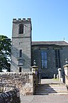 Upload another image | |||
| Blair Adam House | 56°08′46″N 3°24′11″W / 56.14602°N 3.402974°W / 56.14602; -3.402974 (Blair Adam House) | Category A | 5715 | Upload Photo | |||
| Gairney Bridge, Gairney Water | 56°10′23″N 3°24′18″W / 56.173023°N 3.405119°W / 56.173023; -3.405119 (Gairney Bridge, Gairney Water) | Category B | 5281 | Upload Photo | |||
| Cleish House, Kirkton Of Cleish | 56°10′04″N 3°27′44″W / 56.167643°N 3.462273°W / 56.167643; -3.462273 (Cleish House, Kirkton Of Cleish) | Category B | 5710 | Upload Photo | |||
| Dullomuir House | 56°08′38″N 3°23′33″W / 56.143847°N 3.392498°W / 56.143847; -3.392498 (Dullomuir House) | Category B | 5721 | Upload Photo |
Key
The scheme for classifying buildings in Scotland is:
- Category A: "buildings of national or international importance, either architectural or historic; or fine, little-altered examples of some particular period, style or building type."[1]
- Category B: "buildings of regional or more than local importance; or major examples of some particular period, style or building type, which may have been altered."[1]
- Category C: "buildings of local importance; lesser examples of any period, style, or building type, as originally constructed or moderately altered; and simple traditional buildings which group well with other listed buildings."[1]
In March 2016 there were 47,288 listed buildings in Scotland. Of these, 8% were Category A, and 50% were Category B, with the remaining 42% being Category C.[2]
Notes
- ^ Sometimes known as OSGB36, the grid reference (where provided) is based on the British national grid reference system used by the Ordnance Survey.
• "Guide to National Grid". Ordnance Survey. Retrieved 12 December 2007.
• "Get-a-map". Ordnance Survey. Retrieved 17 December 2007. - ^ Historic Environment Scotland assign a unique alphanumeric identifier to each designated site in Scotland, for listed buildings this always begins with "LB", for example "LB12345".
References
- All entries, addresses and coordinates are based on data from Historic Scotland. This data falls under the Open Government Licence
- ^ a b c "What is Listing?". Historic Environment Scotland. Retrieved 29 May 2018.
- ^ Scotland's Historic Environment Audit 2016 (PDF). Historic Environment Scotland and the Built Environment Forum Scotland. pp. 15–16. Retrieved 29 May 2018.
- v
- t
- e
- Aberdalgie
- Aberfeldy
- Abernethy
- Abernyte
- Alyth
- Ardoch
- Arngask
- Auchterarder
- Auchtergaven
- Bendochy
- Blackford
- Blair Atholl
- Blairgowrie and Rattray
- Blairgowrie
- Caputh
- Cargill
- Cleish
- Clunie
- Collace
- Comrie
- Coupar Angus
- Crieff
- Dron
- Dull
- Dunbarney
- Dunkeld and Dowally
- Dunning
- Errol
- Findo Gask
- Forgandenny
- Forteviot
- Fortingall
- Fossoway
- Fowlis Wester
- Glendevon
- Inchture
- Kenmore
- Kettins
- Kilspindie
- Kinclaven
- Kinfauns
- Kinloch
- Kinnaird
- Kinnoull
- Kinross
- Kirkmichael
- Lethendy
- Liff and Benvie
- Little Dunkeld
- Logiealmond
- Logierait
- Longforgan
- Madderty
- Meigle
- Methven
- Moneydie
- Monzievaird and Strowan
- Moulin
- Muckhart
- Muthill
- Orwell
- Perth
- Pitlochry
- Portmoak
- Rattray
- Redgorton
- Rhynd
- Scone
- St Madoes
- St Martins
- Tibbermore
- Trinity Gask
- Weem


