National Register of Historic Places listings in Belknap County, New Hampshire

This is a list of the National Register of Historic Places listings in Belknap County, New Hampshire.
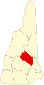
This is intended to be a complete list of the properties and districts on the National Register of Historic Places in Belknap County, New Hampshire, United States. Latitude and longitude coordinates are provided for many National Register properties and districts; these locations may be seen together in a map.[1]
There are 47 properties and districts listed on the National Register in the county.
| Belknap - Carroll - Cheshire - Coös - Grafton - Hillsborough - Merrimack - Rockingham - Strafford - Sullivan |
This National Park Service list is complete through NPS recent listings posted September 5, 2024.[2]
Map all coordinates using OpenStreetMap
Download coordinates as:
- KML
- GPX (all coordinates)
- GPX (primary coordinates)
- GPX (secondary coordinates)
Current listings
| [3] | Name on the Register[4] | Image | Date listed[5] | Location | City or town | Description |
|---|---|---|---|---|---|---|
| 1 | Alton Bay Railroad Station |  | September 22, 1983 (#83001124) | NH 11 43°28′24″N 71°14′17″W / 43.4733°N 71.2381°W / 43.4733; -71.2381 (Alton Bay Railroad Station) | Alton | |
| 1.5 | Bay Meeting House and Vestry | 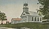 | June 7, 1984 (#84002508i) | Upper Bay and Steele Rds. 43°32′17″N 71°32′12″W / 43.5381°N 71.5367°W / 43.5381; -71.5367 (Bay Meeting House and Vestry) | Sanbornton | |
| 2 | Belknap-Sulloway Mill |  | January 25, 1971 (#71000046) | 25 Beacon Street East 43°31′39″N 71°28′07″W / 43.5276°N 71.4686°W / 43.5276; -71.4686 (Belknap-Sulloway Mill) | Laconia | Now the Belknap Mill Museum;[6] listed as being on "Mill Street". |
| 3 | Belmont Public Library |  | September 12, 1985 (#85002191) | Main St. 43°26′37″N 71°28′57″W / 43.4436°N 71.4825°W / 43.4436; -71.4825 (Belmont Public Library) | Belmont | |
| 4 | John W. Busiel House |  | September 19, 1994 (#94001094) | 30 Church St. 43°31′48″N 71°28′16″W / 43.53°N 71.4711°W / 43.53; -71.4711 (John W. Busiel House) | Laconia | |
| 5 | Busiel-Seeburg Mill |  | January 25, 1971 (#71000047) | 1 Mill Plaza 43°31′40″N 71°28′06″W / 43.5279°N 71.4682°W / 43.5279; -71.4682 (Busiel-Seeburg Mill) | Laconia | Listed as being on "Mill Street" |
| 6 | Centre Congregational Church |  | September 8, 1983 (#83001125) | Province Rd. 43°25′31″N 71°24′51″W / 43.4253°N 71.4142°W / 43.4253; -71.4142 (Centre Congregational Church) | Gilmanton | |
| 7 | Centre Harbor Village Historic District |  | September 8, 1983 (#83001126) | Main and Plymouth Sts. 43°42′32″N 71°27′46″W / 43.7089°N 71.4628°W / 43.7089; -71.4628 (Centre Harbor Village Historic District) | Center Harbor | |
| 8 | Colonial Theatre Complex |  | November 5, 2020 (#100005742) | 609–621 Main St. and 21–31 Canal St. 43°31′42″N 71°28′13″W / 43.5284°N 71.4702°W / 43.5284; -71.4702 (Colonial Theatre Complex) | Laconia | |
| 9 | Dana Meeting House | 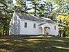 | December 13, 1984 (#84000516) | Dana Hill Rd. 43°38′34″N 71°38′00″W / 43.6428°N 71.6333°W / 43.6428; -71.6333 (Dana Meeting House) | New Hampton | |
| 10 | District No. 9 Schoolhouse |  | March 15, 2000 (#00000198) | 358 Hoyt Rd. 43°31′48″N 71°23′48″W / 43.53°N 71.3967°W / 43.53; -71.3967 (District No. 9 Schoolhouse) | Gilford | |
| 11 | Endicott Rock |  | May 28, 1980 (#80000264) | Weirs Channel 43°36′20″N 71°27′22″W / 43.6056°N 71.4561°W / 43.6056; -71.4561 (Endicott Rock) | Laconia (Weirs Beach) | |
| 12 | Evangelical Baptist Church | 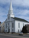 | September 12, 1985 (#85002189) | Veterans Sq. 43°31′45″N 71°28′20″W / 43.5292°N 71.4722°W / 43.5292; -71.4722 (Evangelical Baptist Church) | Laconia | |
| 13 | Federal Building | 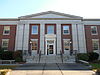 | October 25, 2011 (#11000766) | 719 Main St. 43°31′50″N 71°28′17″W / 43.5306°N 71.4714°W / 43.5306; -71.4714 (Federal Building) | Laconia | |
| 14 | First Baptist Church of Gilmanton |  | December 1, 1989 (#89002059) | Province Rd./NH 107, 0.25 miles north of Stage Rd. 43°22′51″N 71°21′14″W / 43.3808°N 71.3539°W / 43.3808; -71.3539 (First Baptist Church of Gilmanton) | Gilmanton | |
| 15 | First Congregational Church |  | March 9, 1990 (#90000386) | Church St, west of Main St. 43°27′17″N 71°13′20″W / 43.4547°N 71.2222°W / 43.4547; -71.2222 (First Congregational Church) | Alton | |
| 16 | First Free Will Baptist Church in Meredith | 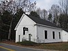 | December 1, 1986 (#86003368) | Winona Rd. 43°38′48″N 71°32′15″W / 43.6467°N 71.5375°W / 43.6467; -71.5375 (First Free Will Baptist Church in Meredith) | Meredith | |
| 17 | First Freewill Baptist Church | 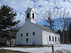 | August 2, 1978 (#78000209) | North of Lovelock 43°31′09″N 71°12′00″W / 43.5192°N 71.2°W / 43.5192; -71.2 (First Freewill Baptist Church) | East Alton | |
| 18 | Oscar Foss Memorial Library |  | November 7, 1985 (#85002779) | Main St. 43°20′21″N 71°15′38″W / 43.3392°N 71.2606°W / 43.3392; -71.2606 (Oscar Foss Memorial Library) | Barnstead | |
| 19 | Gale Memorial Library |  | September 12, 1985 (#85002185) | 695 Main St. 43°31′47″N 71°28′17″W / 43.5297°N 71.4714°W / 43.5297; -71.4714 (Gale Memorial Library) | Laconia | |
| 20 | Dudley Gilman Homestead | 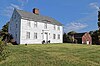 | April 7, 2023 (#100008793) | 60 Mile Hill Rd. 43°30′23″N 71°28′13″W / 43.5063°N 71.4703°W / 43.5063; -71.4703 (Dudley Gilman Homestead) | Belmont | |
| 21 | Gilmanton Academy | 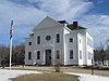 | September 8, 1983 (#83001127) | Province Rd. 43°25′30″N 71°24′50″W / 43.425°N 71.4139°W / 43.425; -71.4139 (Gilmanton Academy) | Gilmanton | |
| 22 | Gilmanton Ironworks Library | 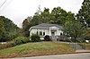 | March 16, 1989 (#89000188) | Elm St. 43°25′03″N 71°17′47″W / 43.4175°N 71.2965°W / 43.4175; -71.2965 (Gilmanton Ironworks Library) | Gilmanton | |
| 23 | Gordon-Nash Library | 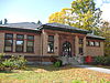 | September 15, 1988 (#88001437) | Main St. 43°36′19″N 71°39′09″W / 43.605278°N 71.6525°W / 43.605278; -71.6525 (Gordon-Nash Library) | New Hampton | |
| 24 | Ossian Wilbur Goss Reading Room | 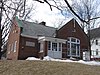 | September 4, 1986 (#86002165) | 188 Elm St. 43°32′57″N 71°27′59″W / 43.549167°N 71.466389°W / 43.549167; -71.466389 (Ossian Wilbur Goss Reading Room) | Laconia (Lakeport) | |
| 25 | House by the Side of the Road |  | November 26, 1980 (#80000265) | 61 School St. 43°26′51″N 71°35′24″W / 43.4475°N 71.59°W / 43.4475; -71.59 (House by the Side of the Road) | Tilton | |
| 26 | Abraham Jaquith House | 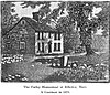 | 1991 (#90000166) | Coordinates missing | Gilmanton, New Hampshire | Built 1725 in Billerica, Massachusetts, moved to Gilmanton in 2000. |
| 27 | Kimball Castle |  | August 16, 1982 (#82001666) | Locke's Hill Rd. 43°35′01″N 71°22′46″W / 43.5835°N 71.3794°W / 43.5835; -71.3794 (Kimball Castle) | Gilford | |
| 28 | Laconia District Court |  | November 9, 1982 (#82004990) | Academy Sq. 43°31′25″N 71°28′11″W / 43.523611°N 71.469722°W / 43.523611; -71.469722 (Laconia District Court) | Laconia | |
| 29 | Laconia Passenger Station |  | January 11, 1982 (#82001667) | Veterans Sq. 43°31′45″N 71°28′21″W / 43.529167°N 71.4725°W / 43.529167; -71.4725 (Laconia Passenger Station) | Laconia | |
| 30 | Lochmere Archeological District | 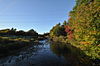 | November 1, 1982 (#82000615) | West bank of the Winnipesaukee River[7] | Tilton | A large area containing numerous Native American artifacts; sites in the district are partially compromised by construction.[7] |
| 31 | Meredith Public Library | 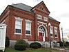 | December 13, 1984 (#84000514) | 50 Main St. 43°39′19″N 71°30′01″W / 43.655277°N 71.500394°W / 43.655277; -71.500394 (Meredith Public Library) | Meredith | |
| 32 | Monument Square Historic District |  | March 15, 1984 (#84002512) | Main, Factory, Church, and Depot Sts. 43°27′19″N 71°13′11″W / 43.455278°N 71.219722°W / 43.455278; -71.219722 (Monument Square Historic District) | Alton | |
| 33 | Washington Mooney House | 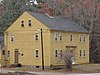 | September 4, 1997 (#97001102) | Junction of NH 104 and Interstate 93 43°36′52″N 71°38′29″W / 43.614444°N 71.641389°W / 43.614444; -71.641389 (Washington Mooney House) | New Hampton | |
| 34 | John J. Morrill Store | 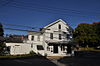 | August 29, 1980 (#80000266) | Belknap Mountain Rd. 43°32′52″N 71°24′23″W / 43.547778°N 71.406389°W / 43.547778; -71.406389 (John J. Morrill Store) | Gilford | |
| 35 | New Hampshire Veterans' Association Historic District | 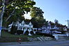 | May 22, 1980 (#80000267) | North of Laconia on Lakeside Ave. 43°36′21″N 71°27′43″W / 43.605833°N 71.461944°W / 43.605833; -71.461944 (New Hampshire Veterans' Association Historic District) | Laconia (Weirs Beach) | |
| 36 | New Hampton Community Church | 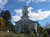 | March 7, 1985 (#85000474) | Main St. 43°36′23″N 71°38′55″W / 43.606389°N 71.648611°W / 43.606389; -71.648611 (New Hampton Community Church) | New Hampton | |
| 37 | New Hampton Town House | 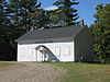 | March 23, 1998 (#98000198) | Junction of Dana Hill and Town House Roads 43°37′27″N 71°37′43″W / 43.624167°N 71.628611°W / 43.624167; -71.628611 (New Hampton Town House) | New Hampton | |
| 38 | Benjamin Rowe House | 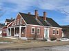 | April 30, 2008 (#07000552) | 88 Belknap Mountain Rd. 43°32′37″N 71°24′10″W / 43.543611°N 71.402778°W / 43.543611; -71.402778 (Benjamin Rowe House) | Gilford | |
| 39 | Sanbornton Square Historic District |  | December 8, 1980 (#80000417) | Sanbornton Square 43°29′33″N 71°35′01″W / 43.4925°N 71.5835°W / 43.4925; -71.5835 (Sanbornton Square Historic District) | Sanbornton | |
| 40 | Second Free Baptist Church |  | March 9, 1990 (#90000387) | Main St., south of Church St. 43°27′18″N 71°13′14″W / 43.455°N 71.220556°W / 43.455; -71.220556 (Second Free Baptist Church) | Alton | |
| 41 | Smith Meeting House | 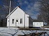 | March 23, 1998 (#98000196) | Junction of Smith Meetinghouse, Parsonage Hill, and Joe Jones Rds. 43°24′57″N 71°21′48″W / 43.415833°N 71.363333°W / 43.415833; -71.363333 (Smith Meeting House) | Gilmanton | |
| 42 | Tilton Downtown Historic District |  | July 7, 1983 (#83001128) | Roughly Main St. between Central and Bridge Sts. 43°26′34″N 71°35′25″W / 43.442778°N 71.590278°W / 43.442778; -71.590278 (Tilton Downtown Historic District) | Tilton | |
| 43 | Tilton Island Park Bridge |  | March 21, 1980 (#80000268) | Tilton Island Park 43°26′32″N 71°35′13″W / 43.442222°N 71.586944°W / 43.442222; -71.586944 (Tilton Island Park Bridge) | Tilton | Over the Winnipesaukee River |
| 44 | Charles E. Tilton Mansion | 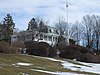 | August 10, 1982 (#82004995) | School St. 43°26′38″N 71°35′28″W / 43.443889°N 71.591111°W / 43.443889; -71.591111 (Charles E. Tilton Mansion) | Tilton | |
| 45 | United Baptist Church of Lakeport | 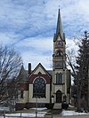 | June 6, 1985 (#85001198) | 23 Park St. 43°32′56″N 71°27′48″W / 43.548889°N 71.463333°W / 43.548889; -71.463333 (United Baptist Church of Lakeport) | Laconia (Lakeport) | |
| 46 | US Post Office-Laconia Main |  | July 18, 1986 (#86002252) | 33 Church St. 43°31′47″N 71°28′10″W / 43.529717°N 71.469508°W / 43.529717; -71.469508 (US Post Office-Laconia Main) | Laconia | |
| 47 | The Weirs | 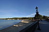 | May 12, 1975 (#75000120) | Near outlet of Lake Winnipesaukee[8] | Laconia (Weirs Beach) | Major Native American archeological site.[8] |
See also
Wikimedia Commons has media related to National Register of Historic Places in Belknap County, New Hampshire.
- List of National Historic Landmarks in New Hampshire
- National Register of Historic Places listings in New Hampshire
References
- Starbuck, David (2006). The Archeology of New Hampshire. Durham, NH: University of New Hampshire Press. ISBN 9781584655626.
- ^ The latitude and longitude information provided in this table was derived originally from the National Register Information System, which has been found to be fairly accurate for about 99% of listings. Some locations in this table may have been corrected to current GPS standards.
- ^ National Park Service, United States Department of the Interior, "National Register of Historic Places: Weekly List Actions", retrieved September 5, 2024.
- ^ Numbers represent an alphabetical ordering by significant words. Various colorings, defined here, differentiate National Historic Landmarks and historic districts from other NRHP buildings, structures, sites or objects.
- ^ "National Register Information System". National Register of Historic Places. National Park Service. April 24, 2008.
- ^ The eight-digit number below each date is the number assigned to each location in the National Register Information System database, which can be viewed by clicking the number.
- ^ Historic Belknap Mill web site
- ^ a b Starbuck, p. 65
- ^ a b Starbuck, pp. 57, 59
- v
- t
- e
- Alton Bay Railroad Station
- Bay Meeting House and Vestry
- Belknap-Sulloway Mill
- Belmont Public Library
- Benjamin Rowe House
- Busiel-Seeburg Mill
- Centre Congregational Church
- Charles E. Tilton Mansion
- Colonial Theatre Complex
- Dana Meeting House
- District No. 9 Schoolhouse
- Endicott Rock
- Evangelical Baptist Church
- Federal Building
- First Baptist Church of Gilmanton
- First Congregational Church
- First Free Will Baptist Church in Meredith
- First Freewill Baptist Church
- Gale Memorial Library
- Gilmanton Academy
- Gilmanton Ironworks Library
- Gordon-Nash Library
- House by the Side of the Road
- John J. Morrill Store
- John W. Busiel House
- Kimball Castle
- Laconia District Court
- Laconia Passenger Station
- Meredith Public Library
- New Hampton Community Church
- New Hampton Town House
- Oscar Foss Memorial Library
- Ossian Wilbur Goss Reading Room
- Second Free Baptist Church
- Smith Meeting House
- The Weirs
- Tilton Island Park Bridge
- United Baptist Church of Lakeport
- US Post Office-Laconia Main
- Washington Mooney House
See also: National Register of Historic Places listings in Belknap County, New Hampshire and List of National Historic Landmarks in New Hampshire
| ||
|---|---|---|
| Topics |  | |
| Lists by county | ||
| Other lists | ||
| ||


Municipalities and communities of Belknap County, New Hampshire, United States | ||
|---|---|---|
County seat: Laconia | ||
| City |  | |
| Towns | ||
| CDPs |
| |
| Other villages | ||
| Footnotes | ‡This populated place also has portions in an adjacent county or counties | |
| ||


