National Register of Historic Places listings in Grand Canyon National Park
This is a list of the National Register of Historic Places listings in Grand Canyon National Park.
This is intended to be a complete list of the properties and districts on the National Register of Historic Places in Grand Canyon National Park, Arizona, United States. The locations of National Register properties and districts for which the latitude and longitude coordinates are included below, may be seen in a Google map.[1]
There are 23 properties and districts listed on the National Register in the park, seven of which are National Historic Landmarks.
This National Park Service list is complete through NPS recent listings posted August 30, 2024.[2]
Map all coordinates using OpenStreetMap
Download coordinates as:
- KML
- GPX (all coordinates)
- GPX (primary coordinates)
- GPX (secondary coordinates)
Current listings
| [3] | Name on the Register | Image | Date listed[4] | Location | City or town | Description |
|---|---|---|---|---|---|---|
| 1 | 1956 Grand Canyon TWA – United Airlines Aviation Accident Site |  | April 22, 2014 (#14000280) | Near the confluence of the Colorado River and Little Colorado River 36°10′30″N 111°50′00″W / 36.175°N 111.833333°W / 36.175; -111.833333 (1956 Grand Canyon TWA – United Airlines Aviation Accident Site) | Grand Canyon National Park | |
| 2 | Horace M. Albright Training Center |  | September 13, 2013 (#13000784) | Albright Ave. & Center Rd. 35°58′41″N 111°59′26″W / 35.978006°N 111.990509°W / 35.978006; -111.990509 (Horace M. Albright Training Center) | Grand Canyon National Park | |
| 3 | Desert View Watchtower Historic District |  | January 3, 1995 (#94001503) | East Rim Drive, about 17 miles (27 km) east of Grand Canyon Village, Desert View 36°02′42″N 111°49′34″W / 36.045°N 111.826111°W / 36.045; -111.826111 (Desert View Watchtower Historic District) | Grand Canyon National Park | Desert View Watchtower, designed by Mary Jane Colter, part of the Mary Jane Colter NHL district |
| 4 | El Tovar Hotel |  | September 6, 1974 (#74000334) | Grand Canyon National Park, Route 8A 36°03′27″N 112°08′13″W / 36.0575°N 112.136944°W / 36.0575; -112.136944 (El Tovar Hotel) | Grand Canyon National Park | National Historic Landmark.hotel on the South Rim of the Grand Canyon |
| 5 | El Tovar Stables |  | September 6, 1974 (#74000336) | Off Grand Canyon National Park Route 8A 36°03′20″N 112°08′28″W / 36.055556°N 112.141111°W / 36.055556; -112.141111 (El Tovar Stables) | Grand Canyon National Park | Stables serving the mule trains that descend to the bottom of the Grand Canyon |
| 6 | Grand Canyon Inn and Campground |  | September 2, 1982 (#82001872) | North Rim 36°12′34″N 112°03′35″W / 36.209444°N 112.059722°W / 36.209444; -112.059722 (Grand Canyon Inn and Campground) | Grand Canyon National Park | Also known as the North Rim Inn, now a store about 1 mile north of the Grand Canyon Lodge |
| 7 | Grand Canyon Lodge |  | September 2, 1982 (#82001721) | North Rim on Bright Angel Point 36°11′57″N 112°03′07″W / 36.199167°N 112.051944°W / 36.199167; -112.051944 (Grand Canyon Lodge) | Grand Canyon National Park | National Historic Landmark lodge and cabins on the edge of the North Rim of the Grand Canyon |
| 8 | Grand Canyon North Rim Headquarters | 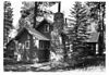 | September 2, 1982 (#82001722) | North Rim 36°12′53″N 112°03′42″W / 36.214722°N 112.061667°W / 36.214722; -112.061667 (Grand Canyon North Rim Headquarters) | Grand Canyon National Park | Park Service administrative district of rustic buildings |
| 9 | Grand Canyon Park Operations Building |  | May 28, 1987 (#87001412) | Off West Rim Dr. 36°03′18″N 112°08′13″W / 36.055°N 112.136944°W / 36.055; -112.136944 (Grand Canyon Park Operations Building) | Grand Canyon National Park | National Historic Landmark, rustic park administration building |
| 10 | Grand Canyon Power House |  | May 28, 1987 (#87001411) | Off West Rim Dr. 36°03′31″N 112°08′26″W / 36.05854°N 112.14065°W / 36.05854; -112.14065 (Grand Canyon Power House) | Grand Canyon National Park | National Historic Landmark, park power plant with creative use of scale and detailing |
| 11 | Grand Canyon Railroad Station |  | September 6, 1974 (#74000337) | Grand Canyon National Park Route 8A 36°03′22″N 112°08′11″W / 36.056111°N 112.136389°W / 36.056111; -112.136389 (Grand Canyon Railroad Station) | Grand Canyon National Park | National Historic Landmark, rustic terminus to the Grand Canyon Railway |
| 12 | Grand Canyon Railway |  | August 23, 2000 (#00000319) | From Williams to Grand Canyon National Park 35°35′59″N 112°12′44″W / 35.599722°N 112.212222°W / 35.599722; -112.212222 (Grand Canyon Railway) | Williams | Former branch of the Atchison, Topeka and Santa Fe Railway to the South Rim |
| 13 | Grand Canyon Village Historic District |  | November 20, 1975 (#75000343) | State Route 64 36°03′22″N 112°08′21″W / 36.056111°N 112.139167°W / 36.056111; -112.139167 (Grand Canyon Village Historic District) | Grand Canyon National Park | National Historic Landmark, the largest developed area in the national park system |
| 14 | Grandview Mine |  | July 9, 1974 (#74000347) | Grand Canyon National Park 36°01′05″N 111°58′32″W / 36.018056°N 111.975556°W / 36.018056; -111.975556 (Grandview Mine) | Grand Canyon National Park | Remnant of former mining activity |
| 15 | Hermits Rest Concession Building |  | August 7, 1974 (#74000335) | Grand Canyon National Park 36°03′40″N 112°12′40″W / 36.061111°N 112.211111°W / 36.061111; -112.211111 (Hermits Rest Concession Building) | Grand Canyon National Park | Rustic store and museum designed by Mary Jane Colter to resemble a Hopi pueblo |
| 16 | Mary Jane Colter Buildings | | May 28, 1987 (#87001436) | Grand Canyon Village and East Rim Drive, about 17 miles (27 km) east of Grand Canyon Village, Desert View 36°03′29″N 112°08′13″W / 36.0581°N 112.1369°W / 36.0581; -112.1369 (Mary Jane Colter Buildings) | Grand Canyon National Park | Four National Historic Landmark properties: Hopi House, Desert View Watchtower, Lookout Studio, Hermit's Rest |
| 17 | Navajo Steel Arch Highway Bridge |  | August 13, 1981 (#81000134) | Southwest of Lee 36°49′05″N 111°37′52″W / 36.818056°N 111.631111°W / 36.818056; -111.631111 (Navajo Steel Arch Highway Bridge) | Lee's Ferry | Highway bridge over the upper Grand Canyon |
| 18 | Buckey O'Neill Cabin | 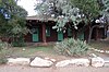 | October 29, 1975 (#75000227) | Off State Route 64 in Grand Canyon National Park 36°03′26″N 112°08′26″W / 36.057222°N 112.140556°W / 36.057222; -112.140556 (Buckey O'Neill Cabin) | Grand Canyon National Park | Part of the Bright Angel Lodge, the cabin perches right on the rim of the canyon |
| 19 | Ranger's Dormitory |  | September 5, 1975 (#75000219) | Off State Route 64 in Grand Canyon National Park 36°03′20″N 112°08′11″W / 36.055556°N 112.136389°W / 36.055556; -112.136389 (Ranger's Dormitory) | Grand Canyon National Park | Rustic Park Service employee housing |
| 20 | Superintendent's Residence |  | September 6, 1974 (#74000450) | Off Route 8A in Grand Canyon National Park 36°03′22″N 112°08′05″W / 36.056111°N 112.134722°W / 36.056111; -112.134722 (Superintendent's Residence) | Grand Canyon National Park | Highly-detailed National Park Service Rustic structure |
| 21 | Trans-Canyon Telephone Line, Grand Canyon National Park |  | May 13, 1986 (#86001102) | Grand Canyon along the Bright Angel and North Kaibab Trails from the South Rim to Roaring Springs and the South Kaibab Trail to Tipoff 36°06′36″N 112°05′34″W / 36.11°N 112.092778°W / 36.11; -112.092778 (Trans-Canyon Telephone Line, Grand Canyon National Park) | Grand Canyon National Park | Innovative communication line between the North and South Rims |
| 22 | Tusayan Ruins |  | July 10, 1974 (#74000285) | Grand Canyon National Park 36°00′49″N 111°51′56″W / 36.013611°N 111.865556°W / 36.013611; -111.865556 (Tusayan Ruins) | Grand Canyon National Park | Pueblo culture ruins and museum |
| 23 | Water Reclamation Plant |  | September 6, 1974 (#74000348) | South of Grand Canyon National Park, Route 8A 36°02′54″N 112°09′19″W / 36.048333°N 112.155278°W / 36.048333; -112.155278 (Water Reclamation Plant) | Grand Canyon National Park | Innovative water treatment system, one of the first of its kind |
See also
- National Register of Historic Places listings in Coconino County, Arizona
- List of National Historic Landmarks in Arizona
- National Register of Historic Places listings in Arizona
Wikimedia Commons has media related to National Register of Historic Places in Grand Canyon National Park.
References
- ^ The latitude and longitude information provided in this table was derived originally from the National Register Information System, which has been found to be fairly accurate for about 99% of listings. Some locations in this table may have been corrected to current GPS standards.
- ^ National Park Service, United States Department of the Interior, "National Register of Historic Places: Weekly List Actions", retrieved August 30, 2024.
- ^ Numbers represent an alphabetical ordering by significant words. Various colorings, defined here, differentiate National Historic Landmarks and historic districts from other NRHP buildings, structures, sites or objects.
- ^ The eight-digit number below each date is the number assigned to each location in the National Register Information System database, which can be viewed by clicking the number.
- v
- t
- e
See also: National Register of Historic Places listings in Grand Canyon National Park
| |
|---|---|
| Topics | |
| Lists by state |
|
| Lists by insular areas | |
| Lists by associated state | |
| Other areas | |
| Related | |
| |


