Newton Butte
Prominence in the Grand Canyon, Arizona, United States


Newton Butte
Coconino County, Arizona, U.S.
Hermit Formation, Supai Group (redbeds), Muav Limestone
Newton Butte, in the Grand Canyon, Arizona, United States is a prominence below the South Rim, northwest of Grandview Point, and north on a ridgeline from Shoshone Point which is one mile east of Yaki Point, East Rim Drive. Shoshone Point and Yaki are both on access roads from East Rim Drive, with Yaki being the more advantageous to different viewing directions.
Newton Butte is 5,940 feet (1,811 m),[1] and located on a point/ridge, just south of Granite Gorge on the Colorado River. The point location of Newton Butte extends due north from an intermediate point on the South Rim, Shoshone Point,[3] which at the end of the Newton Butte point ridgeline, also forms the west perimeter of the Lonetree Canyon drainage, into Granite Gorge.
Just north of Newton Butte, 3/4 mi on the end of the point, is Pattie Butte, a lower elevation prominence, 5,306 feet (1,617 m).[3]
Two hiking trails are closest to Newton Butte. Across Granite Gorge, views south can be made from the Clear Creek Trail, at lower elevations or as it climbs past Zoroaster Canyon to ridgelines at the west of Clear Creek. The Tonto Trail on the Tonto Platform, south side of Granite Gorge, has the closest hiking points near the bottom elevations of Newton Butte.
Newton Butte is named for Sir Isaac Newton (1642–1727), and was officially adopted in 1906 by the U.S. Board on Geographic Names.[2]
Access
Newton Butte can be viewed from the South Rim viewpoints from Yavapai Point, Yaki Point, Shoshone Point, or Grandview Point. Access to East Rim Drive. South Rim, is from the east, on Arizona State Route 64, from US 89. A west access to East Rim Drive is from Williams, Arizona, or Flagstaff, by way of U.S. Route 180 in Arizona.
Gallery
-
 Newton Butte in bullseye, from Yaki Point. (Pattie Butte lower left)
 -
 Newton Butte on the right
 -
-
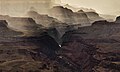
 O'Neill Butte, (above Supai Group 'redbeds'), on ridgeline from Yaki Point; (Newton Butte prominence off photo, right)
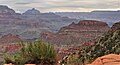
View northeast, with Cape Royal (point) on Walhalla Plateau (Kaibab Plateau), and flat-top of Wotans Throne and Vishnu Temple prominence.
(from Yavapai Point, west of Yaki Point, South Rim) -
 (view east-northeast, from Mather Point-(Yavapai Point))
O'Neill Butte, on ridgeline north, from Newton Butte. Pattie Butte sits on an upper platform of Redwall Limestone, overlain by a 2nd-platform of Surprise Canyon Formation. (partly eroded)


See also
- The Howlands Butte, across Granite Gorge, ~2 mi
References
Wikimedia Commons has media related to Pattie Butte, Coconino Sandstone, Hermit Formation and Supai Group – redbeds.
Wikimedia Commons has media related to Newton Butte.
- ^ a b c "Newton Butte". ListsOfJohn.com. Retrieved 2014-02-08.
- ^ a b "Newton Butte". Geographic Names Information System. United States Geological Survey, United States Department of the Interior. Retrieved 2014-02-07.
- ^ a b Arizona Road & Recreation Atlas (2nd ed.). DeLorme. 1998. p. 13.
External links
- "Shoshone Point". Geographic Names Information System. United States Geological Survey, United States Department of the Interior. part of Newton Butte
- v
- t
- e
(Yavapai County)
- Boundary Cone
- Fortification Hill
- Mount Wilson
- Mount Union
- Castle Dome
- Carr Peak
- Miller Peak
- Aubrey Peak
- Hualapai Peak
- Lime Peak
- Mae West Peaks
- Four Peaks
- Mount Ord
- East End
- McDowell Peak
- Mount McDowell
- Thompson Peak
- Mount Ballard (Arizona)
- Camelback Mountain
- Mummy Mountain
- Piestewa Peak
- South Mountains
- Sunnyslope Mountain
- Ibex Peak
- Agassiz Peak
- Doyle Peak
- Fremont Peak
- Mount Bigelow
- Mount Lemmon
- Pusch Ridge
- Thimble Peak
- Mount Hopkins
- Mount Wrightson
- Mount Turnbull
- Mistake Peak
- Granite Mountain
- Black Dome
- Sentinel Peak
- Tumamoc Hill
- Apache Peak
- Black Mesa (Navajo County)
- Escudilla Mountain
- Mount Baldy
- Agathla Peak
- Agua Caliente Mountains
- Agua Dulce Mountains
- Antelope Hill
- Aquarius Mountains
- Artillery Mountains
- Atascosa Mountains
- Aubrey Hills
- Baboquivari Peak
- Balakai Mesa
- Beaver Dam Mountains
- Belmont Mountains
- Bill Williams Mountain
- Bitsihuitsos Butte
- Black Hills (Greenlee County)
- Black Mesa (Apache-Navajo Counties)
- Black Mesa (Warm Springs)
- Black Mountain (Maricopa County)
- Black Mountain (Pima County)
- Blackjack Mountains
- Bryan Mountains
- Buckskin Mountain (Arizona-Utah)
- Buckskin Mountains (La Paz County)
- Bush Head
- Cabeza Prieta Mountains
- Canelo Hills
- Carrizo Mountains
- Cerro Colorado Mountains
- Chocolate Mountains
- Copper Mountains
- Coyote Mountains
- Date Creek Mountains
- Dome Rock Mountains
- Dos Cabezas Mountains
- Etoi Ki
- Excalibur
- Galiuro Mountains
- Gavilan Peak
- Gila Bend Mountains
- Gila Mountains (Graham County)
- Gila Mountains (Yuma County)
- Goldfield Mountains
- Grand Wash Cliffs
- Granite Mountains
- Granite Wash Mountains
- Growler Mountains
- Gu Achi Peak
- Guadalupe Mountains
- Harcuvar Mountains
- Harquahala Mountains
- House Mountain
- Hunts Mesa
- Isis Temple
- John the Baptist Mountains
- Juniper Mesa
- Kaibab Plateau
- Kofa Mountains
- Laguna Mountains
- Las Guijas Mountains
- Lime Mountain (Maricopa County}
- Little Harquahala Mountains
- Little Rincon Mountains
- Lukachukai Mountains
- Madrean Sky Islands
- Mescal Mountains
- Mineral Mountains
- Moccasin Mountains
- Mohave Mountains
- Mohawk Mountains
- Mount Trumbull
- Muggins Mountains
- Mustang Mountains
- Navajo Mountain
- The Needles
- New River Mountains
- New Water Mountains
- Newton Butte
- Painted Rock Mountains
- Pajarito Mountains
- Patagonia Mountains
- Peacock Mountains
- Picacho Peak
- Picketpost Mountain
- Pinnacle Peak
- Poachie Range
- Poston Butte
- Rawhide Mountains
- Sacaton Mountains
- San Luis Mountains
- Santa Maria Mountains
- Sevenmile Mountains
- Sierra San Antonio
- Sierra Estrella
- Sierra Madre Occidental
- Sierra Pinta
- Silver Bell Mountains
- Squaw Tits
- Sugarloaf Mountain
- Sunset Mountains
- Swisshelm Mountains
- Tempe Butte
- Temple Butte
- Tinajas Altas Mountains
- Tordillo Mountain
- Tortolita Mountains
- Trigo Mountains
- Tule Mountains
- Tumacacori Mountains
- Virgin Mountains
- Vulcan's Throne
- Vulture Mountains
- Waterman Mountains
- Weaver Mountains
- West Silver Bell Mountains
- White Tank Mountains
- Wickenburg Mountains


