National Register of Historic Places listings in Kendall County, Illinois

This is a list of the National Register of Historic Places listings in Kendall County, Illinois.
This is intended to be a complete list of the properties and districts on the National Register of Historic Places in Kendall County, Illinois, United States. Latitude and longitude coordinates are provided for many National Register properties and districts; these locations may be seen together in a map.[1]
There are 11 properties and districts listed on the National Register in the county.
This National Park Service list is complete through NPS recent listings posted August 30, 2024.[2]
Map all coordinates using OpenStreetMap
Download coordinates as:
- KML
- GPX (all coordinates)
- GPX (primary coordinates)
- GPX (secondary coordinates)
Current listings
| [3] | Name on the Register | Image | Date listed[4] | Location | City or town | Description |
|---|---|---|---|---|---|---|
| 1 | Bristol Congregational Church |  | September 6, 2016 (#16000580) | 107 W. Center St. 41°38′51″N 88°26′50″W / 41.647568°N 88.447101°W / 41.647568; -88.447101 (Bristol Congregational Church) | Yorkville | Aka the Chapel on the Green |
| 2 | Chicago, Burlington & Quincy Railroad Depot |  | November 12, 1993 (#93001238) | 101 W. Main St. 41°39′44″N 88°32′17″W / 41.662222°N 88.538056°W / 41.662222; -88.538056 (Chicago, Burlington & Quincy Railroad Depot) | Plano | |
| 3 | Downtown Oswego Historic District | Upload image | August 15, 2022 (#100007995) | Roughly bounded by one-half blk. north of Jackson St., the alleys immediately west and east of Main St., and one-half block south of Washington St. 41°41′02″N 88°21′08″W / 41.6839°N 88.3523°W / 41.6839; -88.3523 (Downtown Oswego Historic District) | Oswego | |
| 4 | Evelyn Site | Upload image | December 19, 1978 (#78001159) | Midway between Newark and Lisbon Center Rds., east of Big Grove Rd.[5] 41°31′49″N 88°30′26″W / 41.53027°N 88.50722°W / 41.53027; -88.50722 (Evelyn Site) | Newark | |
| 5 | Farnsworth House |  | October 7, 2004 (#04000867) | 14520 River Rd. 41°38′15″N 88°32′07″W / 41.6375°N 88.535278°W / 41.6375; -88.535278 (Farnsworth House) | Plano | |
| 6 | Kendall County Courthouse |  | November 12, 1998 (#98001354) | 109 W. Ridge St. 41°38′25″N 88°26′53″W / 41.640278°N 88.448056°W / 41.640278; -88.448056 (Kendall County Courthouse) | Yorkville | |
| 7 | Plano Hotel |  | November 12, 1993 (#93001239) | 120 W. Main St. 41°39′44″N 88°32′21″W / 41.662222°N 88.539167°W / 41.662222; -88.539167 (Plano Hotel) | Plano | |
| 8 | Reorganized Church of Jesus Christ of Latter Day Saints |  | November 2, 1990 (#90001724) | 304 S. Center Ave. 41°39′33″N 88°32′09″W / 41.659167°N 88.535833°W / 41.659167; -88.535833 (Reorganized Church of Jesus Christ of Latter Day Saints) | Plano | |
| 9 | Albert H. Sears House |  | January 29, 1987 (#86003720) | 603 E. North St. 41°39′55″N 88°31′49″W / 41.665278°N 88.530278°W / 41.665278; -88.530278 (Albert H. Sears House) | Plano | |
| 10 | Lewis Steward House | 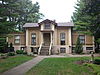 | November 28, 2003 (#03001200) | 611 E. Main St. 41°39′54″N 88°31′47″W / 41.665°N 88.529722°W / 41.665; -88.529722 (Lewis Steward House) | Plano | |
| 11 | Yorkville School |  | January 24, 1995 (#94001600) | 201 W. Center St. 41°38′52″N 88°26′53″W / 41.647778°N 88.448056°W / 41.647778; -88.448056 (Yorkville School) | Yorkville |
See also
Wikimedia Commons has media related to National Register of Historic Places in Kendall County, Illinois.
- List of National Historic Landmarks in Illinois
- National Register of Historic Places listings in Illinois
References
- ^ The latitude and longitude information provided in this table was derived originally from the National Register Information System, which has been found to be fairly accurate for about 99% of listings. Some locations in this table may have been corrected to current GPS standards.
- ^ National Park Service, United States Department of the Interior, "National Register of Historic Places: Weekly List Actions", retrieved August 30, 2024.
- ^ Numbers represent an alphabetical ordering by significant words. Various colorings, defined here, differentiate National Historic Landmarks and historic districts from other NRHP buildings, structures, sites or objects.
- ^ The eight-digit number below each date is the number assigned to each location in the National Register Information System database, which can be viewed by clicking the number.
- ^ Maruszak, Kathleen. National Register of Historic Places Inventory/Nomination: Evelyn Site. National Park Service, 1978-04, 7.
- v
- t
- e
- Adams
- Alexander
- Bond
- Boone
- Brown
- Bureau
- Calhoun
- Carroll
- Cass
- Champaign
- Christian
- Clark
- Clay
- Clinton
- Coles
- Cook
- Crawford
- Cumberland
- DeKalb
- DeWitt
- Douglas
- DuPage
- Edgar
- Edwards
- Effingham
- Fayette
- Ford
- Franklin
- Fulton
- Gallatin
- Greene
- Grundy
- Hamilton
- Hancock
- Hardin
- Henderson
- Henry
- Iroquois
- Jackson
- Jasper
- Jefferson
- Jersey
- Jo Daviess
- Johnson
- Kane
- Kankakee
- Kendall
- Knox
- LaSalle
- Lake
- Lawrence
- Lee
- Livingston
- Logan
- Macon
- Macoupin
- Madison
- Marion
- Marshall
- Mason
- Massac
- McDonough
- McHenry
- McLean
- Menard
- Mercer
- Monroe
- Montgomery
- Morgan
- Moultrie
- Ogle
- Peoria
- Perry
- Piatt
- Pike
- Pope
- Pulaski
- Putnam
- Randolph
- Richland
- Rock Island
- St. Clair
- Saline
- Sangamon
- Schuyler
- Scott
- Shelby
- Stark
- Stephenson
- Tazewell
- Union
- Vermilion
- Wabash
- Warren
- Washington
- Wayne
- White
- Whiteside
- Will
- Williamson
- Winnebago
- Woodford

- Bridges
- Houses
- National Historic Landmarks
- Properties of religious function
- Railway stations
Municipalities and communities of Kendall County, Illinois, United States | ||
|---|---|---|
County seat: Yorkville | ||
| Cities |  | |
| Villages | ||
| Townships | ||
| CDP | ||
| Other unincorporated communities | ||
| Footnotes | ‡This populated place also has portions in an adjacent county or counties | |
| ||


