National Register of Historic Places listings in Warren County, Illinois

This is a list of the National Register of Historic Places listings in Warren County, Illinois.
This is intended to be a complete list of the properties and districts on the National Register of Historic Places in Warren County, Illinois, United States. Latitude and longitude coordinates are provided for many National Register properties and districts; these locations may be seen together in a map.[1]
There are 11 properties and districts listed on the National Register in the county.
This National Park Service list is complete through NPS recent listings posted August 16, 2024.[2]
Map all coordinates using OpenStreetMap
Download coordinates as:
- KML
- GPX (all coordinates)
- GPX (primary coordinates)
- GPX (secondary coordinates)
Current listings
| [3] | Name on the Register[4] | Image | Date listed[5] | Location | City or town | Description |
|---|---|---|---|---|---|---|
| 1 | Alexis Opera House | 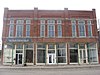 | July 30, 1987 (#87001267) | 101-105 N. Main St. 41°03′47″N 90°33′21″W / 41.062917°N 90.555972°W / 41.062917; -90.555972 (Alexis Opera House) | Alexis | |
| 2 | May (Carns) and John E. Brewer House | Upload image | December 26, 2023 (#100009641) | 320 South First Street 40°54′31″N 90°38′50″W / 40.9086°N 90.6472°W / 40.9086; -90.6472 (May (Carns) and John E. Brewer House) | Monmouth | |
| 3 | Carr House | 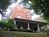 | August 11, 1988 (#88001229) | 416 E. Broadway 40°54′44″N 90°38′36″W / 40.912222°N 90.643333°W / 40.912222; -90.643333 (Carr House) | Monmouth | |
| 4 | E. B. Colwell and Company Department Store |  | February 3, 1993 (#92001851) | 208 S. Main St. and 211 S. A St. 40°54′38″N 90°38′55″W / 40.910556°N 90.648611°W / 40.910556; -90.648611 (E. B. Colwell and Company Department Store) | Monmouth | |
| 5 | Sarah Martin House |  | October 9, 1980 (#80001414) | 310 E. Broadway 40°54′44″N 90°38′42″W / 40.912222°N 90.645000°W / 40.912222; -90.645000 (Sarah Martin House) | Monmouth | |
| 6 | Monmouth Courthouse Commercial Historic District |  | February 1, 2006 (#05001604) | Roughly bounded by Archer Ave., 1st St., 2nd Ave., and A St. 40°54′43″N 90°38′54″W / 40.911944°N 90.648333°W / 40.911944; -90.648333 (Monmouth Courthouse Commercial Historic District) | Monmouth | |
| 7 | Patton Block Building |  | November 2, 1990 (#90001727) | 88 and 90 Public Sq. 40°54′46″N 90°38′55″W / 40.912639°N 90.648611°W / 40.912639; -90.648611 (Patton Block Building) | Monmouth | |
| 8 | Pike-Sheldon House |  | August 12, 1999 (#99000976) | 406 S. Third St. 40°54′29″N 90°38′41″W / 40.908056°N 90.644722°W / 40.908056; -90.644722 (Pike-Sheldon House) | Monmouth | |
| 9 | Ivory Quinby House |  | November 20, 1980 (#80001415) | 605 N. 6th St. 40°55′03″N 90°38′25″W / 40.917500°N 90.640278°W / 40.917500; -90.640278 (Ivory Quinby House) | Monmouth | |
| 10 | Minnie Stewart House |  | October 19, 1989 (#89001733) | 1015 E. Euclid Ave. 40°55′00″N 90°38′07″W / 40.916667°N 90.635278°W / 40.916667; -90.635278 (Minnie Stewart House) | Monmouth | |
| 11 | William S. Weir, Jr. House |  | August 18, 1992 (#92001004) | 402 E. Broadway 40°54′44″N 90°38′38″W / 40.912222°N 90.643889°W / 40.912222; -90.643889 (William S. Weir, Jr. House) | Monmouth |
See also
Wikimedia Commons has media related to National Register of Historic Places in Warren County, Illinois.
- List of National Historic Landmarks in Illinois
- National Register of Historic Places listings in Illinois
References
- ^ The latitude and longitude information provided in this table was derived originally from the National Register Information System, which has been found to be fairly accurate for about 99% of listings. Some locations in this table may have been corrected to current GPS standards.
- ^ National Park Service, United States Department of the Interior, "National Register of Historic Places: Weekly List Actions", retrieved August 16, 2024.
- ^ Numbers represent an alphabetical ordering by significant words. Various colorings, defined here, differentiate National Historic Landmarks and historic districts from other NRHP buildings, structures, sites or objects.
- ^ "National Register Information System". National Register of Historic Places. National Park Service. March 13, 2009.
- ^ The eight-digit number below each date is the number assigned to each location in the National Register Information System database, which can be viewed by clicking the number.
- v
- t
- e
- Adams
- Alexander
- Bond
- Boone
- Brown
- Bureau
- Calhoun
- Carroll
- Cass
- Champaign
- Christian
- Clark
- Clay
- Clinton
- Coles
- Cook
- Crawford
- Cumberland
- DeKalb
- DeWitt
- Douglas
- DuPage
- Edgar
- Edwards
- Effingham
- Fayette
- Ford
- Franklin
- Fulton
- Gallatin
- Greene
- Grundy
- Hamilton
- Hancock
- Hardin
- Henderson
- Henry
- Iroquois
- Jackson
- Jasper
- Jefferson
- Jersey
- Jo Daviess
- Johnson
- Kane
- Kankakee
- Kendall
- Knox
- LaSalle
- Lake
- Lawrence
- Lee
- Livingston
- Logan
- Macon
- Macoupin
- Madison
- Marion
- Marshall
- Mason
- Massac
- McDonough
- McHenry
- McLean
- Menard
- Mercer
- Monroe
- Montgomery
- Morgan
- Moultrie
- Ogle
- Peoria
- Perry
- Piatt
- Pike
- Pope
- Pulaski
- Putnam
- Randolph
- Richland
- Rock Island
- St. Clair
- Saline
- Sangamon
- Schuyler
- Scott
- Shelby
- Stark
- Stephenson
- Tazewell
- Union
- Vermilion
- Wabash
- Warren
- Washington
- Wayne
- White
- Whiteside
- Will
- Williamson
- Winnebago
- Woodford

- Bridges
- Houses
- National Historic Landmarks
- Properties of religious function
- Railway stations


