Otis Peak
Mountain in the state of Colorado


Otis Peak
Location in Colorado
Show map of Colorado
Otis Peak
Otis Peak (the United States)
Show map of the United StatesFront Range[5]
Otis Peak is a 12,486-foot-elevation (3,806-meter) mountain summit on the boundary shared by Grand County and Larimer County, in Colorado, United States.
Description
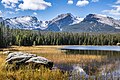
Otis Peak is set along the Continental Divide in the Front Range of the Rocky Mountains.[3] The mountain is situated within Rocky Mountain National Park and 11 miles (18 km) southwest of Estes Park. Precipitation runoff from the mountain drains chiefly into tributaries of Glacier Creek which in turn is a tributary of the Big Thompson River, and the lower west slope drains to Grand Lake via North Inlet. A portion of that water that arrives at Grand Lake is then diverted to the east side of the Continental Divide via the Alva B. Adams Tunnel which is bored under Otis Peak.[7] Topographic relief is significant as the summit rises 2,300 feet (700 meters) above Loch Vale in one mile.
Etymology
The mountain's toponym was reported in publications as early as 1915,[8] and was officially adopted in 1932 by the United States Board on Geographic Names.[9] The peak is named for Dr. Edward Osgood Otis (1848–1933), a recognized authority on tuberculosis, who spent time mountain climbing in this area in the 1880s.[10]
Climate
According to the Köppen climate classification system, Otis Peak is located in an alpine subarctic climate zone with cold, snowy winters, and cool to warm summers.[11] Due to its altitude, it receives precipitation all year, as snow in winter, and as thunderstorms in summer, with a dry period in late spring. This climate supports the Andrews Glacier below the south slope of Otis Peak.
Gallery
-
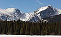 Otis Peak (left) and Hallett Peak from northeast
 -
 Otis Peak (left), Hallett Peak (center), Flattop Mountain (right)
 -
 Taylor Peak, Otis Peak, and Hallett Peak
 -
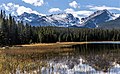
 Otis Peak


See also
- List of peaks in Rocky Mountain National Park
- Mountains of Larimer County, Colorado
 Mountains portal

Notes
Elevation for Otis Peak ranges from 12,481 feet measured by LiDAR,[2] 12,486 feet on USGS topographical map, and 12,504 feet with a GPS unit.[4]
References
- ^ Robert M. Ormes (1992), Guide to the Colorado Mountains, Johnson Books, ISBN 9781555661946, p. 42.
- ^ a b c d e "Otis Peak - 13,481' CO". listsofjohn.com. Retrieved April 23, 2023.
- ^ a b "Otis Peak, Peakvisor.com". Retrieved April 22, 2023.
- ^ a b "Otis Peak". Geographic Names Information System. United States Geological Survey, United States Department of the Interior. Retrieved April 23, 2023.
- ^ "Otis Peak, Colorado". Peakbagger.com. Retrieved April 23, 2023.
- ^ a b Geologic map of the Estes Park 30' x 60' quadrangle, north-central Colorado, W.A. Braddock, U.S. Geological Survey, 1984.
- ^ Phyllis J. Perry (2008), Rocky Mountain National Park, Arcadia Publishing, ISBN 978-0-7385-5627-7, p. 94.
- ^ R. B. Marshall (1915), Results of Spirit Leveling in Colorado, US Government Printing Office, p. 184.
- ^ Decisions of the United States Geographic Board No. 27, (June 30, 1932), US Government Printing Office, p. 7.
- ^ Essays and Monographs in Colorado History (1983), Publisher: Colorado Historical Society, p. 84.
- ^ Peel, M. C.; Finlayson, B. L.; McMahon, T. A. (2007). "Updated world map of the Köppen−Geiger climate classification". Hydrol. Earth Syst. Sci. 11. ISSN 1027-5606.
External links
Wikimedia Commons has media related to Otis Peak.
- Weather forecast: Otis Peak
- Dr. Edward Osgood Otis in memoriam: National Library of Medicine
- Otis Peak rock climbing: Mountainproject.com
- v
- t
- e
Places adjacent to Otis Peak
| Snowdrift Lake | Hallett Peak | Estes Park |
 | ||
| Continental Divide |  Otis Peak Otis Peak | The Loch |
 | ||
| Andrews Glacier | The Sharkstooth | Thatchtop |


