The Sharkstooth
Mountain in the state of Colorado


The Sharkstooth
Location in Colorado
Show map of Colorado
The Sharkstooth
The Sharkstooth (the United States)
Show map of the United StatesFront Range[2]
The Sharkstooth is a 12,630-foot-elevation (3,850-meter) mountain summit in Larimer County, Colorado, United States.[4]
Description
The Sharkstooth is set 1,500 feet east of the Continental Divide in the Front Range of the Rocky Mountains. It is in the "Cathedral Spires" area,[7] and is the second-steepest point in Colorado.[1] The summit is situated within Rocky Mountain National Park, approximately 11 miles (18 km) southwest of Estes Park. Precipitation runoff from the mountain drains into tributaries of Glacier Creek which in turn is a tributary of the Big Thompson River. Topographic relief is significant with the summit rising 2,200 feet (670 meters) above Loch Vale in one mile. The landforms's toponym has been officially adopted by the United States Board on Geographic Names.[4]
Climate
According to the Köppen climate classification system, The Sharkstooth is located in an alpine subarctic climate zone with cold, snowy winters, and cool to warm summers.[8] Due to its altitude, it receives precipitation all year, as snow in winter, and as thunderstorms in summer, with a dry period in late spring.
Gallery
-
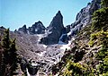 North aspect of Sharkstooth viewed from The Gash
 -
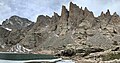 Cathedral Spires seen from Sky Pond. The apparent highest spire is "Saber" and immediately left of it is "Petit Grepon". At far left edge is Taylor Peak. Even though Sharkstooth is higher, it is hidden behind Saber.
 -
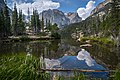 The top of Sharkstooth is the apparent highest point, view from The Loch


See also
- List of peaks in Rocky Mountain National Park
- Mountains of Larimer County, Colorado
 Mountains portal

References
- ^ a b John Fayhee (2012), The Colorado Mountain Companion: A Potpourri of Useful Miscellany from the Highest Parts of the Highest State, West Margin Press, ISBN 9780871089670
- ^ a b "Sharkstooth, Colorado". Peakbagger.com. Retrieved April 26, 2023.
- ^ a b c d "Sharkstooth, The - 12,531' CO". listsofjohn.com. Retrieved April 26, 2023.
- ^ a b c "The Sharkstooth". Geographic Names Information System. United States Geological Survey, United States Department of the Interior. Retrieved April 26, 2023.
- ^ George Wuerthner (2001), Rocky Mountain National Park Visitors Companion, Stackpole Books,ISBN 0-8117-2919-2, p. 22.
- ^ a b Geologic map of the Estes Park 30' x 60' quadrangle, north-central Colorado, W.A. Braddock, U.S. Geological Survey, 1984.
- ^ "The Sharkstooth, Peakvisor.com". Retrieved April 26, 2023.
- ^ Peel, M. C.; Finlayson, B. L.; McMahon, T. A. (2007). "Updated world map of the Köppen−Geiger climate classification". Hydrol. Earth Syst. Sci. 11. ISSN 1027-5606.
External links
- Weather forecast: The Sharkstooth
- The Sharkstooth rock climbing: Mountainproject.com
Places adjacent to The Sharkstooth | ||||||||||||||||
|---|---|---|---|---|---|---|---|---|---|---|---|---|---|---|---|---|
| ||||||||||||||||


- v
- t
- e

- Mount Garfield
- Aspen Mountain
- Capitol Peak
- Castle Peak
- Cathedral Peak
- Chair Mountain
- Crested Butte
- Gothic Mountain
- Italian Mountain
- Maroon Bells
- Mount Emmons
- Mount Owen
- Mount Sopris
- Pyramid Peak
- Snowmass Mountain
- Snowmass Peak
- Treasure Mountain
- Black Mountain (Moffat County)
- Columbus Mountain
- Elk Mountain (Routt County)
- Hahns Peak
- Flat Top Mountain
- Sleepy Cat Peak
- Eagles Nest
- Jacque Peak
- Meridian Peak
- Mount Powell
- The Spider
- Crater Peak
- North Mamm Peak
- Clark Peak
- Arkansas Hills
- Clinton Peak
- Dyer Mountain
- Gemini Peak
- Horseshoe Mountain
- Mount Arkansas
- Mount Bross
- Mount Buckskin
- Mount Democrat
- Mount Lincoln
- Mount Sheridan
- Mount Sherman
- Pacific Peak
- West Buffalo Peak
- Elk Mountain (Grand County)
- Parkview Mountain
- Radial Mountain
- Whiteley Peak
| Sangre de Cristo Range |
|
|---|---|
| Wet Mountains |
|
| Others |
|
| Collegiate Peaks |
|
|---|---|
| Others |
|
- Crystal Peak
- Fletcher Mountain
- Peak 10
- Peak One
- Quandary Peak
- Tenmile Peak
- Bear Mountain
- Blair Mountain
- Chalk Mountains
- Cochetopa Hills
- Dawson Butte
- Diamond Peak
- Flirtation Peak
- Granite Peak
- Grand Hogback
- Grannys Nipple
- Horsefly Peak
- Lead Mountain (Grand County)
- Mount Neva
- Powell Peak
- San Luis Hills
- Storm King Mountain
- Terrible Mountain
- Two Buttes
- Ute Mountain


