Tamar–Tavy Estuary
50°24′41″N 4°12′12″W / 50.4113°N 4.2032°W / 50.4113; -4.2032
The Tamar–Tavy Estuary is a Site of Special Scientific Interest (SSSI) covering the tidal estuaries of the River Tamar and the River Tavy on the border between Cornwall and Devon in England, UK. Part of the Tamar estuary also forms the Tamar Estuary Nature Reserve, owned by the Cornwall Wildlife Trust. The site was designated in 1991 for its biodiversity and varying habitats that support many wader and wildfowl species, as well as the special interest of its marine biology.
Geography
The 1,422-hectare (3,510-acre) SSSI encompasses the entirety of the tidal regions of the Tamar; from Gunnislake down to the Tamar Bridge in the south, where it forms the Hamoaze, and the River Tavy from Lopwell to its discharge in the Tamar. The site also includes Kingsmill Lake, Tamerton Lake and a few other tributary streams of the Tamar, as well as the marshes around Morwellham Quay.[1]
The site forms part of the Tamar Estuaries Complex Special Protection Area (SPA), along with the estuary of the River Lynher and St John's Lake,[2] as well as forming part of the Plymouth Sound and Estuaries Special Area of Conservation (SAC).[3]
The Cornwall Wildlife Trust owns the 109 hectares (270 acres) Tamar Estuary nature reserve around Kingsmill Lake, below Landulph,[4][5] and Lopwell Dam is a Local Nature Reserve, covering the dam and surrounding woodlands.[6]
Wildlife and ecology
The SSSI, due to its habitats, is of international importance for nature conservation, in particular as a wintering site for wildfowl and wader birds.[7]
Mudflats form the lower reaches of the estuary system and are bordered by salt marsh, inundation grassland and rocky shoreline habitats. These mainly contain common saltmarsh-grass (Puccinellia maritima), red fescue and sea couch, as well as two nationally scarce species of grass: stiff saltmarsh-grass (Puccinellia rupestris) and bulbous foxtail. The upstream part of the system supports freshwater marsh, fen, rush pasture and reedmarsh habitats, along with wooded valleys in places. Species include the common reed and the only known population in the British Isles of triangular club-rush, part of the genus Schoenoplectus.[7]
The mudflats attract more than 20% of the British wintering population of the uncommon pied avocet. They additionally support black-tailed godwit, common redshank, dunlin, whimbrel, greenshank, spotted redshank and green sandpiper during the wintering period,[7] with the first birds arriving in October and leaving again throughout March.[5]
The highly variable salinity along the transition from marine estuary to river allows for a diverse marine culture. Seaweeds, green algae and communities of polychaete worms are all found in the estuary system; near Calstock is found the shrimp Palaemon longirostris, which has been recorded in only two other estuaries in Britain.[7] The estuary is also one of only two sites in the UK where the fish, allis shad, spawn.[8]
Other larger animals found in undisturbed parts of the SSSI include the European otter, the common kingfisher[7] and dormice.[6]
Gallery
-
 River Tamar from Calstock Viaduct
 -
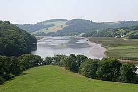 Mudflats and salt marshes on the lower reaches of the estuary system
 -
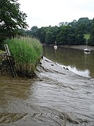
 Salt marsh on a lower bank of the River Tamar
 -
 A reedmarsh on the upper reaches of the Tamar, at Cotehele
 -
 The Lopwell Dam, a weir that is the tidal limit of the River Tavy


References
 Cornwall portal

- ^ "Tamar–Tavy Estuary map". Natural England. 25 October 2011. Retrieved 9 November 2011.
- ^ "Tamar Estuaries Complex". Joint Nature Conservation Committee. 2001. Retrieved 11 November 2011.
- ^ "Plymouth Sound and Estuaries". Joint Nature Conservation Committee. Retrieved 11 November 2011.
- ^ Ordnance Survey: Explorer map sheet 108 Lower Tamar Valley & Plymouth ISBN 978-0-319-23709-0
- ^ a b "Tamar Estuary Nature Reserve". Cornwall Wildlife Trust. Archived from the original on 27 March 2012. Retrieved 9 November 2011.
- ^ a b "Local Nature Reserves: Lopwell Dam". South West Lakes Trust. Retrieved 11 November 2011.
- ^ a b c d e "Tamar–Tavy Estuary" (PDF). Natural England. 1991. Retrieved 10 November 2011.
- ^ "Allis shad returning to Tamar estuary". BBC News Online. 12 July 2011. Retrieved 10 November 2011.
External links
![]() Media related to Tamar Estuary at Wikimedia Commons
Media related to Tamar Estuary at Wikimedia Commons
![]() Media related to Tavy Estuary at Wikimedia Commons
Media related to Tavy Estuary at Wikimedia Commons
- v
- t
- e
- Aire Point to Carrick Du
- Amble Marshes
- Baulk Head to Mullion
- Bedruthan Steps and Park Head
- Boconnoc Park and Woods
- Bodmin Moor, North
- Borlasevath and Retallack Moor
- Boscastle to Widemouth
- Brendonmoor
- Breney Common
- Bude Coast
- Cabilla Manor Wood
- Caerthillian to Kennack
- Carnkief Pond
- Carrick Heaths
- Carricknath Point to Porthbean Beach
- Carrine Common & Penwethers
- Chyenhal Moor
- Cligga Head
- Coombe Mill
- Coverack to Porthoustock
- Crow's Nest
- Crowhill Valley
- Dozmary Pool
- Draynes Wood
- East Lizard Heathlands
- Eglarooze Cliff
- Gerrans Bay to Camels Cove
- Godrevy Head to St Agnes
- Goonhilly Downs
- Goss and Tregoss Moors
- Greenamoor
- Greenscoombe Wood, Luckett
- Grimscott
- Gwithian to Mexico Towans
- Hayle Estuary & Carrack Gladden
- Kelsey Head
- Kennack to Coverack
- Kernick and Ottery Meadows
- Loe Pool
- Loggans Moor
- Lower Bostraze and Leswidden
- Lower Fal & Helford Intertidal
- Lymsworthy Meadows
- Lynher Estuary
- Malpas Estuary
- Marazion Marsh
- Meddon Moor
- Meneage Coastal Section
- Merthen Wood
- Minster Church
- Mullion Cliff to Predannack Cliff
- Nance Wood
- Newlyn Downs
- Ottery Valley
- Park Wood
- Penhale Dunes
- Pentire Peninsula
- Phoenix United Mine
- Plymouth Sound Shores And Cliffs
- Polruan to Polperro
- Polyne Quarry
- Porthgwarra to Pordenack Point
- Rame Head & Whitsand Bay
- Red Moor
- Redlake Meadows & Hoggs Moor
- Retire Common
- River Camel Valley and Tributaries
- Rock Dunes
- Rosemullion
- Rosenannon Bog and Downs
- St Austell Clay Pits
- St John's Lake
- St Nectan's Glen
- Steeple Point to Marsland Mouth
- Swanpool
- Sylvia's Meadow
- Talland Barton
- Tamar–Tavy Estuary
- Tintagel Cliffs
- Treen Cliff
- Tregonetha & Belowda Downs
- Tregonning Hill
- Trehane Barton
- Trelow Downs
- Trevose Head and Constantine Bay
- Upper Fal Estuary and Woods
- Upper Fowey Valley
- Ventongimps Moor
- West Cornwall Bryophytes
- West Lizard
- Annet
- Big Pool and Browarth Point
- Castle Down (Tresco)
- Chapel Down
- Eastern Isles
- Great Pool
- Gugh
- Higher Moors and Porth Hellick Pool
- Lower Moors
- Norrard Rocks
- Peninnis Head
- Pentle Bay, Merrick And Round Islands
- Plains and Great Bay
- Pool Of Bryher & Popplestone Bank
- Rushy Bay and Heathy Hill
- Samson
- Shipman Head & Shipman Down
- St Helen's
- St Martin's Sedimentary Shore
- Teän
- Western Rocks
- White Island
- Wingletang Down


