Ealing Common
 Ealing Common Ealing Common and West Acton | |
|---|---|
 | |
| Stazione della | metropolitana di Londra |
| Gestore | Transport for London |
| Inaugurazione | 1879 |
| Stato | in uso |
| Linea |   |
| Localizzazione | Ealing Common, Ealing |
| Zona tariffaria | Zona 3 |
| Tipologia | Stazione di superficie |
| Interscambio | linee di superficie |
| Flusso passeggeri | 2010 2011 2012 2013 2014 |
  Ealing Common | |
| Metropolitane del mondo | |
| Modifica dati su Wikidata · Manuale | |
 |  | Upminster | ||
| | Upminster Bridge | |||
| | Hornchurch | |||
| | Elm Park | |||
| | Dagenham East | |||
| | Dagenham Heathway | |||
| | Becontree | |||
| | Upney | |||
 | | Barking | ||
| | | East Ham | ||
| | | Upton Park | ||
| | | Plaistow | ||
  | | West Ham | ||
| | | Bromley-by-Bow | ||
| | | Bow Road | ||
 | | Mile End | ||
| | | Stepney Green | ||
 | | Whitechapel | ||
| | | Aldgate East | ||
  | | Tower Hill | ||
  | | Monument | ||
| | | Cannon Street | ||
| | | Mansion House | ||
| | | Blackfriars | ||
| | | Temple | ||
 | | Embankment | ||
| | | Westminster | ||
| Edgware Road | | | St. James's Park | |
| Paddington | | | Victoria  | |
| Bayswater | | | Sloane Square | |
| Notting Hill Gate | | | S. Kensington  | |
| High Str. Kensington | | | Gloucester Road | |
| | | Earl's Court | ||
| Kensington (Olympia) | | |||
| West Kensington | | | West Brompton | |
| Barons Court | | | Fulham Broadway | |
| Hammersmith | | | Parsons Green | |
| Ravenscourt Park | | | Putney Bridge | |
| Stamford Brook | | | East Putney | |
| Turnham Green | | | Southfields | |
| | Wimbledon Park | |||
| | Wimbledon  | |||
| Chiswick Park | | | Gunnersbury | |
| Acton Town | | | Kew Gardens | |
| Ealing Common | | | Richmond | |
| Ealing Broadway | | | ||
| | Cockfosters | ||||||
| | Oakwood | ||||||
| | Southgate | ||||||
| | Arnos Grove | ||||||
| | Bounds Green | ||||||
| | Wood Green | ||||||
| | Turnpike Lane | ||||||
| | Manor House | ||||||
 | | Finsbury Park | |||||
| | Arsenal | ||||||
| | Holloway Road | ||||||
| | Caledonian Road | ||||||
    | | King's Cross St. Pancras | |||||
| | Russell Square | ||||||
 | | Holborn | |||||
| | Covent Garden | ||||||
| | | Leicester Square | |||||
 | | Piccadilly Circus | |||||
 | | Green Park | |||||
| | Hyde Park Corner | ||||||
| | Knightsbridge | ||||||
 | | South Kensington | |||||
| | | Gloucester Road | |||||
| | | Earl's Court | |||||
| | | Barons Court | |||||
| | | Hammersmith | |||||
| | | Turnham Green | |||||
| | | Acton Town | |||||
| Ealing Common | | | South Ealing | ||||
| North Ealing | | | Northfields | ||||
| Park Royal | | | Boston Manor | ||||
| Alperton | | | Osterley | ||||
| Sudbury Town | | | Hounslow East | ||||
| Sudbury Hill | | | Hounslow Central | ||||
| South Harrow | | | Hounslow West | ||||
| Rayners Lane | | | Hatton Cross | ||||
| Eastcote | | | Heathrow T2 & 3   | ||||
| Ruislip Manor | | Heathrow T4 | | ||||
| Ruislip | | | Heathrow T5 | ||||
| Ickenham | | | |||||
| Hillingdon | | | |||||
| Uxbridge | | | |||||
La stazione di Ealing Common è una stazione della metropolitana di Londra situata sulle linee District e Piccadilly.
Storia
La stazione di Ealing Common è stata aperta il 1º luglio 1879[2] dalla District Railway (DR, poi divenuta la linea District), sulla linea da Turnham Green a Ealing Broadway. Nel 1886 la stazione è stata rinominata Ealing Common and West Acton, nome che ha mantenuto fino al 1910 per poi riprendere il suo nome originale[3]. Nel giugno 1903 la DR ha aperto la diramazione sulla linea dalla zona nord di Ealing Common fino all'allora stazione di Park Royal & Twyford Abbey (dal 1931 sostituita da Park Royal[3][4]).
Tra il 1930 e il 1931 l'edificio della stazione originale del 1879 è stato sostituito da uno nuovo, su progetto dell'architetto Charles Holden. Il 4 luglio 1932 è cominciato il servizio della linea Piccadilly, in comune con la tratta della linea District fino a Ealing Common[3][5]. Da Ealing Common fino a South Harrow la linea Piccadilly ha sostituito la District, che prosegue oltre Ealing Common solo sulla linea fino alla stazione di Ealing Broadway.
Strutture e impianti
Ealing Common sorge lungo Uxbridge Road, circa 450 m a est dall'incrocio con Gunnersbury Avenue e Hanger Lane.
Il design della stazione, costruita negli anni 30, si ispira a quello della stazione di Morden, realizzata nel 1926 dalla City and South London Railway e oggi parte della linea Northern[4], ed è anche simile a Hounslow West, aperta nello stesso periodo: entrambe queste stazioni sono state progettate da Charles Holden. Realizzata in Pietra di Portland, la stazione ha una biglietteria ettagonale con vetrate su tutti i lati.
Il 17 maggio 1994 l'edificio della stazione è diventato un monumento classificato di grado II[6].
La stazione rientra nella Travelcard Zone 3.
Interscambi
Nelle vicinanze della stazione effettuano fermata alcune linee urbane automobilistiche, gestite da London Buses[7].
 Fermata autobus

Galleria d'immagini
-
 Il binario ovest
 -
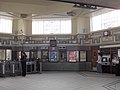 Interni della stazione
 -
 Treno della Piccadilly in partenza dalla stazione di Ealing Common
 -
 Il logo dell'Underground nella stazione di Ealing Common


Note
- ^ a b c d e (EN) Multi-year station entry-and-exit figures (XLS), in London Underground station passenger usage data, Transport for London, 2017. URL consultato il 15 dicembre 2018 (archiviato dall'url originale il 16 aprile 2014).
- ^ (EN) Clive's Underground Line Guides - District Line, Dates, su davros.org. URL consultato il 17 dicembre 2020.
- ^ a b c DR.
- ^ a b JDF.
- ^ (EN) Clive's Underground Line Guides - Piccadilly Line, Dates, su davros.org. URL consultato il 17 dicembre 2020.
- ^ (EN) Ealing Common London Regional Transport Underground Station, including vestibule shops and platforms, su historicengland.org.uk, National Heritage List for England. URL consultato il 15 dicembre 2018.
- ^ (EN) Buses nearby Ealing Common Underground Station, su tfl.gov.uk. URL consultato il 15 dicembre 2018.
Bibliografia
- (EN) Douglas Rose, The London Underground, A Diagrammatic History, 7ª ed., Douglas Rose/Capital Transport, 1999 [1980], ISBN 1-85414-219-4.
- (EN) J.E. Connor, London's Disused Underground Stations, 2ª ed., Capital Transport, 2006 [1999], ISBN 1-85414-250-X.
- (EN) John R. Day, John Reed, The Story of London's Underground, 11ª ed., Capital Transport, 2010 [1963], ISBN 978-1-85414-341-9.
- (EN) Tony Beard, By Tube Beyond Edgware, Capital Transport, 2002, ISBN 978-1-85414-246-7.
- (EN) R.V.J. Butt, The Directory of Railway Stations, Patrick Stephens Ltd, 1995, ISBN 1-85260-508-1.
- (EN) Christian Wolmar, The Subterranean Railway: How the London Underground Was Built and How It Changed the City Forever, Atlantic Books, 2005 [2004], ISBN 978-1-84354-023-6.
- (EN) Joe Brown, London Railway Atlas, 3ª ed., Ian Allan Publishing, 2013, ISBN 978-0-7110-3728-1.
- Anthony Sutcliffe, London: An Architectural History, Yale University Press, 2006, ISBN 978-0-300-11006-7. URL consultato il 17 novembre 2018.
- Cyril M. Harris, What's in a name?, 4a, Capital Transport, 2001 [1977], ISBN 978-1-85414-241-2.
- Antony Badsey-Ellis, Underground Heritage, Capital Transport, 2012, ISBN 978-1-85414-360-0.
- David Bownes, Oliver Green e Sam Mullins, Underground: How the Tube Shaped London, Allen Lane, 2012, ISBN 978-1-84614-462-2.
- Mike Horne, The Northern Line: An Illustrated History, 3a, Capital Transport, 2009 [1990], ISBN 978-1-85414-326-6.
Altri progetti
Altri progetti
- Wikimedia Commons
 Wikimedia Commons contiene immagini o altri file su stazione di Ealing Common
Collegamenti esterni
- Ealing Common nell'archivio fotografico del London Transport Museum, su ltmuseum.co.uk. URL consultato il 15 dicembre 2018 (archiviato dall'url originale il 16 dicembre 2018).
| Capolinea | Fermata precedente | | Fermata successiva | Capolinea | ||||
|---|---|---|---|---|---|---|---|---|
| Ealing Broadway |  | Ealing Broadway | Ealing Common | Acton Town |  | Edgware Road/Upminster |
| Capolinea | Fermata precedente | | Fermata successiva | Capolinea | ||||
|---|---|---|---|---|---|---|---|---|
| Uxbridge | | North Ealing | Ealing Common | Acton Town | | Cockfosters |
V · D · M | ||
|---|---|---|
| Stazioni | Acton Town · Aldgate East · Barking · Barons Court · Bayswater · Becontree · Blackfriars · Bow Road · Bromley-by-Bow · Cannon Street · Chiswick Park · Dagenham East · Dagenham Heathway · Ealing Broadway · Ealing Common · Earl's Court · East Ham · East Putney · Edgware Road · Elm Park · Embankment · Fulham Broadway · Gloucester Road · Gunnersbury · Hammersmith · High Street Kensington · Hornchurch · Kensington (Olympia) · Kew Gardens · Mansion House · Mile End · Monument · Notting Hill Gate · Paddington · Parsons Green · Plaistow · Putney Bridge · Ravenscourt Park · Richmond · Sloane Square · South Kensington · Southfields · St. James's Park · Stamford Brook · Stepney Green · Temple · Tower Hill · Turnham Green · Upminster · Upminster Bridge · Upney · Upton Park · Victoria · West Brompton · West Ham · West Kensington · Westminster · Whitechapel · Wimbledon · Wimbledon Park |   |
| Treni in uso | C69 & C77 · D78 | |
| Trasporti a Londra · Metropolitana di Londra · Transport for London | ||
 Portale Londra


