Marindol
Place in White Carniola, Slovenia
45°30′17.58″N 15°19′53.58″E / 45.5048833°N 15.3315500°E / 45.5048833; 15.3315500 Slovenia
 (2020)
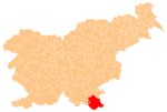
Marindol (pronounced [ˈmaːɾindɔl]) is a settlement on the terrace above the left bank of the Kolpa River in the Municipality of Črnomelj in the White Carniola area of southeastern Slovenia. The area is part of the traditional region of Lower Carniola and is now included in the Southeast Slovenia Statistical Region.[2]
Name
Marindol was first attested in written sources in 1477 as Marintall (and in 1490 as Marental). The name is a compound formed from *Mari(ji)n dol (literally, 'Mary's valley').[3] The settlement was also once known as Šobatovci or Šobatovo selo,[4] or Šabotovo/Šobotovo selo, cited as Shebatova sella in 1674.[5]
References
- ^ Statistical Office of the Republic of Slovenia
- ^ Črnomelj municipal site
- ^ Snoj, Marko (2009). Etimološki slovar slovenskih zemljepisnih imen. Ljubljana: Modrijan. p. 252.
- ^ Savnik, Roman (1971). Krajevni leksikon Slovenije, vol. 2. Ljubljana: Državna založba Slovenije. p. 45.
- ^ Terseglav, Marko. 1996. Uskoška pesemska dediščina Bele Krajine. Ljubljana: ZRC SAZU, pp. 22–23.
External links
- Marindol on Geopedia
- v
- t
- e
Administrative seat: Črnomelj
- Črnomelj Castle
- Črnomelj Mithraeum
- Lahinja Regional Park
- Stonič Castle
- St. Peter's Parish Church
| Authority control databases |
|
|---|
 | This article about the Municipality of Črnomelj in Slovenia is a stub. You can help Wikipedia by expanding it. |
- v
- t
- e


