National Register of Historic Places listings in Greenwich, Connecticut
This is a list of the National Register of Historic Places listings in Greenwich, Connecticut.
Map all coordinates using OpenStreetMap
Download coordinates as:
- KML
- GPX (all coordinates)
- GPX (primary coordinates)
- GPX (secondary coordinates)
This is intended to be a complete list of the properties and districts on the National Register of Historic Places in Greenwich. The locations of National Register properties and districts for which the latitude and longitude coordinates are included below, may be seen in an online map.[1]
There are 295 properties and districts listed on the National Register in Fairfield County. This list covers the 35 properties located partially or entirely in Greenwich. Ones in Bridgeport or Stamford are covered in National Register of Historic Places listings in Bridgeport, Connecticut, or in National Register of Historic Places listings in Stamford, Connecticut. The remainder are covered in National Register of Historic Places listings in Fairfield County, Connecticut.
Current listings
| [2] | Name on the Register[3] | Image | Date listed[4] | Location | Description |
|---|---|---|---|---|---|
| 1 | Bush-Holley House |  | December 1, 1988 (#88002694) | 39 Strickland Rd., in Cos Cob[5]: 2 41°02′02″N 73°35′52″W / 41.0338°N 73.5977°W / 41.0338; -73.5977 (Bush-Holley House) | Home of Cos Cob Art Colony, c.1890-1920. Current headquarters and museum of the Greenwich Historical Society. |
| 2 | Byram School |  | August 2, 1990 (#90001110) | Between Sherman Ave. and Western Junior Highway, in Byram[6]: 3 41°00′46″N 73°39′13″W / 41.012778°N 73.653611°W / 41.012778; -73.653611 (Byram School) | "Exceptional" for its architecture.[7] |
| 3 | Cos Cob Power Station |  | August 2, 1990 (#90001096) | Roughly bounded by Metro North railroad tracks, the Mianus River, and Sound Shore Dr. 41°01′46″N 73°35′50″W / 41.029444°N 73.597222°W / 41.029444; -73.597222 (Cos Cob Power Station) | Significant for its role in the first mainline railroad electrification in the United States. It was the largest component in an enormous scale experiment to implement AC power in railroad power, part of complying with a 1903 New York State law prohibiting steam locomotives in New York City.[8] The building was demolished in 2001, but is still listed. |
| 4 | Cos Cob Railroad Station | 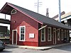 | July 28, 1989 (#89000928) | 55 Station Dr. 41°01′47″N 73°36′02″W / 41.029722°N 73.600556°W / 41.029722; -73.600556 (Cos Cob Railroad Station) | A working train station |
| 5 | Samuel Ferris House |  | August 10, 1989 (#89001086) | 1 Cary St., in Riverside 41°02′32″N 73°35′19″W / 41.042194°N 73.588639°W / 41.042194; -73.588639 (Samuel Ferris House) | |
| 6 | Fourth Ward Historic District | 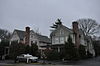 | April 21, 2000 (#00000324) | Roughly along Church, Division, Northfield and William Sts.; and Putnam Court and Sherwood Place in downtown Greenwich 41°02′06″N 73°37′40″W / 41.035°N 73.627778°W / 41.035; -73.627778 (Fourth Ward Historic District) | |
| 7 | French Farm |  | April 3, 1975 (#75001918) | North of downtown Greenwich at the junction of Lake Ave. and Round Hill Rd. 41°03′07″N 73°38′24″W / 41.051944°N 73.64°W / 41.051944; -73.64 (French Farm) | |
| 8 | Glenville Historic District |  | March 9, 2007 (#07000107) | Roughly along Glen Ridge Rd., Glenville Rd., Glenville St., Pemberwick Rd., Riversville Rd., and Weaver St. 41°02′17″N 73°39′53″W / 41.038056°N 73.664722°W / 41.038056; -73.664722 (Glenville Historic District) | |
| 9 | Glenville School |  | November 21, 2003 (#03001169) | 449 Pemberwick Rd., in the Glenville Historic District[9] 41°02′12″N 73°39′52″W / 41.036667°N 73.664444°W / 41.036667; -73.664444 (Glenville School) | 1921 school by James O. Betelle is only T-shaped Georgian Revival school in Greenwich. Now West Greenwich Civic Center. |
| 10 | Great Captain Island Lighthouse |  | April 3, 1991 (#91000351) | Great Captain Island, southwest of Greenwich Point 40°58′57″N 73°37′26″W / 40.9825°N 73.623889°W / 40.9825; -73.623889 (Great Captain Island Lighthouse) | |
| 11 | Greenwich Avenue Historic District |  | August 31, 1989 (#89001215) | Roughly bounded by Railroad, Arch, Field Point, W. Elm, Greenwich, Putnam, Mason, Havemeyer, and Bruce, in downtown Greenwich 41°01′33″N 73°37′36″W / 41.025833°N 73.626667°W / 41.025833; -73.626667 (Greenwich Avenue Historic District) | |
| 12 | Greenwich Municipal Center Historic District |  | July 26, 1988 (#88000579) | 101 Field Point Rd., 290, 299, 310 Greenwich Ave., in downtown Greenwich 41°01′29″N 73°37′37″W / 41.024722°N 73.626944°W / 41.024722; -73.626944 (Greenwich Municipal Center Historic District) | |
| 13 | Greenwich Point Historic District |  | July 12, 2021 (#100004671) | Tod's Driftway at Shore Rd. 41°00′17″N 73°34′45″W / 41.0046°N 73.5793°W / 41.0046; -73.5793 (Greenwich Point Historic District) | |
| 14 | Greenwich Town Hall |  | May 21, 1987 (#87000807) | 299 Greenwich Ave., in downtown Greenwich 41°01′30″N 73°37′32″W / 41.025°N 73.625556°W / 41.025; -73.625556 (Greenwich Town Hall) | |
| 15 | Greenwich YMCA |  | November 7, 1996 (#83004541) | 50 E. Putnam Ave., in downtown Greenwich[10]: 2 41°01′55″N 73°37′32″W / 41.031944°N 73.625556°W / 41.031944; -73.625556 (Greenwich YMCA) | |
| 16 | Indian Harbor Yacht Club |  | July 22, 2010 (#10000494) | 710 Steamboat Rd. 41°00′42″N 73°37′22″W / 41.011667°N 73.622778°W / 41.011667; -73.622778 (Indian Harbor Yacht Club) | |
| 17 | Knapp Tavern |  | September 15, 1977 (#77001389) | 243 E. Putnam Ave. 41°02′13″N 73°37′10″W / 41.036944°N 73.619444°W / 41.036944; -73.619444 (Knapp Tavern) | |
| 18 | Little Bethel African Methodist Episcopal Church |  | October 12, 2010 (#10000831) | 44 Lake Ave. 41°01′58″N 73°37′51″W / 41.0329°N 73.6308°W / 41.0329; -73.6308 (Little Bethel African Methodist Episcopal Church) | |
| 19 | Thomas Lyon House | 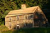 | August 24, 1977 (#77001390) | W. Putnam Ave. and Byram Rd. 41°00′52″N 73°39′16″W / 41.014444°N 73.654444°W / 41.014444; -73.654444 (Thomas Lyon House) | |
| 20 | Merritt Parkway |  | April 17, 1991 (#91000410) | Route 15 right-of-way between the New York state line and the Sikorsky Memorial Bridge 41°05′26″N 73°39′30″W / 41.090556°N 73.658333°W / 41.090556; -73.658333 (Merritt Parkway) | Historic parkway; also located in Stamford, New Canaan, Norwalk, Westport, Fairfield, Trumbull, and Stratford |
| 21 | Methodist Episcopal Church |  | August 25, 1988 (#88001343) | 61 E. Putnam Ave. 41°01′58″N 73°37′35″W / 41.032778°N 73.626389°W / 41.032778; -73.626389 (Methodist Episcopal Church) | |
| 22 | Mianus River Railroad Bridge |  | June 12, 1987 (#87000845) | Metro-North New Haven Line right-of-way at the Mianus River 41°01′51″N 73°35′41″W / 41.030833°N 73.594722°W / 41.030833; -73.594722 (Mianus River Railroad Bridge) | |
| 23 | Nathaniel Witherell Historic District |  | June 9, 2010 (#10000346) | 70 Parsonage Rd. 41°03′41″N 73°37′37″W / 41.061508°N 73.626922°W / 41.061508; -73.626922 (Nathaniel Witherell Historic District) | |
| 24 | New Mill and Depot Building, Hawthorne Woolen Mill | | February 23, 1990 (#90000152) | 350 Pemberwick Rd., in Glenville[11] 41°02′13″N 73°40′00″W / 41.036944°N 73.666667°W / 41.036944; -73.666667 (New Mill and Depot Building, Hawthorne Woolen Mill) | 1875 mill and depot (accompanying railroad was never built) show unusually high style for functional buildings of that era. Now a retail/office complex. |
| 25 | Putnam Hill Historic District |  | August 24, 1979 (#79002657) | U.S. Route 1 between Maple Ave and Old Church Rd 41°02′11″N 73°37′09″W / 41.036389°N 73.619167°W / 41.036389; -73.619167 (Putnam Hill Historic District) | |
| 26 | River Road-Mead Avenue Historic District |  | April 28, 2014 (#14000171) | Roughly along Mead Ave. & River Rd. 41°02′15″N 73°35′45″W / 41.0375°N 73.5958°W / 41.0375; -73.5958 (River Road-Mead Avenue Historic District) | |
| 27 | Riverside Avenue Bridge |  | August 29, 1977 (#77001391) | Riverside Ave. and Metro-North New Haven Line railroad tracks 41°01′54″N 73°35′18″W / 41.031667°N 73.588333°W / 41.031667; -73.588333 (Riverside Avenue Bridge) | |
| 28 | Rosemary Hall |  | August 28, 1998 (#90001137) | Junction of Ridgeway and Zaccheus Mead Ln. in the Rockridge neighborhood[12]: 3 41°02′15″N 73°38′12″W / 41.0375°N 73.636667°W / 41.0375; -73.636667 (Rosemary Hall) | Former campus of Rosemary Hall School, now Carmel Academy and The Japanese School of New York. |
| 29 | Round Hill Historic District |  | July 25, 1996 (#96000779) | Roughly the junction of John St. and Round Hill Rd., in the Back Country of Greenwich 41°06′17″N 73°40′06″W / 41.1048°N 73.6683°W / 41.1048; -73.6683 (Round Hill Historic District) | |
| 30 | Sylvanus Selleck Gristmill |  | August 2, 1990 (#90001109) | 124 Old Mill Rd. in northern Greenwich[13]: 10 41°05′31″N 73°39′33″W / 41.0919°N 73.6592°W / 41.0919; -73.6592 (Sylvanus Selleck Gristmill) | A 1796 gristmill. |
| 31 | Sound Beach Railroad Station |  | July 28, 1989 (#89000929) | 160 Sound Beach Ave., in Old Greenwich 41°02′00″N 73°34′05″W / 41.033333°N 73.568056°W / 41.033333; -73.568056 (Sound Beach Railroad Station) | A working railroad station in the Old Greenwich (formerly called "Sound Beach") section of Greenwich |
| 32 | Strickland Road Historic District |  | March 22, 1990 (#77001625) | 19-47 Strickland Rd. in Cos Cob[14]: 2 41°02′06″N 73°36′03″W / 41.035°N 73.600833°W / 41.035; -73.600833 (Strickland Road Historic District) | |
| 33 | US Post Office-Greenwich Main |  | January 16, 1986 (#86000077) | 310 Greenwich Ave., in downtown Greenwich 41°01′26″N 73°37′33″W / 41.023889°N 73.625833°W / 41.023889; -73.625833 (US Post Office-Greenwich Main) | |
| 34 | William E. Ward House |  | November 7, 1976 (#76001294) | Comly Ave. in Glenville[15] 41°01′34″N 73°40′03″W / 41.026111°N 73.6675°W / 41.026111; -73.6675 (William E. Ward House) | First reinforced concrete structure in U.S., built in the 1870s on state line, and extending into Rye Brook, New York |
| 35 | Josiah Wilcox House | 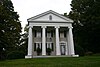 | November 30, 1988 (#88001344) | 354 Riversville Rd. in the Riversville neighborhood[16]: 2 41°03′51″N 73°40′32″W / 41.06425°N 73.675444°W / 41.06425; -73.675444 (Josiah Wilcox House) |
See also
Wikimedia Commons has media related to National Register of Historic Places in Greenwich, Connecticut.
- National Register of Historic Places listings in Fairfield County, Connecticut
- National Register of Historic Places listings in Stamford, Connecticut
- National Register of Historic Places listings in Bridgeport, Connecticut
- List of National Historic Landmarks in Connecticut
References
- ^ The latitude and longitude information provided in this table was derived originally from the National Register Information System, which has been found to be fairly accurate for about 99% of listings. Some locations in this table may have been corrected to current GPS standards.
- ^ Numbers represent an alphabetical ordering by significant words. Various colorings, defined here, differentiate National Historic Landmarks and historic districts from other NRHP buildings, structures, sites or objects.
- ^ "National Register Information System". National Register of Historic Places. National Park Service. March 13, 2009.
- ^ The eight-digit number below each date is the number assigned to each location in the National Register Information System database, which can be viewed by clicking the number.
- ^ https://npgallery.nps.gov/NRHP/GetAsset/NRHP/88002694_text
- ^ https://npgallery.nps.gov/NRHP/GetAsset/NRHP/90001110_text
- ^ Jan Cunningham (June 30, 1989). "National Register of Historic Places Inventory-Nomination: Byram School". National Park Service. and Accompanying eight photos, exterior and interior, from 1989 (see captions page 6 of text document)
- ^ Matthew Roth and Bruce Clouette (November 27, 1989). "National Register of Historic Places Registration: Cos Cob Power Station". National Park Service. and Accompanying 14 photos, exterior and interior, from 1989
- ^ https://npgallery.nps.gov/NRHP/GetAsset/NRHP/07000107_text
- ^ https://npgallery.nps.gov/NRHP/GetAsset/NRHP/83004541_text
- ^ https://npgallery.nps.gov/NRHP/GetAsset/NRHP/90000152_text
- ^ https://npgallery.nps.gov/NRHP/GetAsset/NRHP/90001137_text
- ^ https://npgallery.nps.gov/NRHP/GetAsset/NRHP/90001109_text
- ^ https://npgallery.nps.gov/NRHP/GetAsset/NRHP/77001625_text
- ^ http://www.oprhp.state.ny.us/hpimaging/hp_view.asp?GroupView=10697
- ^ https://npgallery.nps.gov/NRHP/GetAsset/NRHP/88001344_text
- v
- t
- e
Geography
neighborhoods
- Calf Island
- Great Captain Island
Education
secondary schools
| Closed |
|---|
Other
- Bush–Holley House
- Byram School
- Cos Cob station
- Cos Cob Power Station
- Samuel Ferris House
- Glenville School
- Great Captain Island Light
- Greenwich Town Hall
- Greenwich Y.M.C.A.
- Indian Harbor Yacht Club building
- Thomas Lyon House
- Mianus River Railroad Bridge
- The Nathaniel Witherell
- Methodist Episcopal Church
- New Mill and Depot Building, Hawthorne Woolen Mill
- Old Greenwich station
- Phebe Seaman House
- Putnam Cottage (Knapp Tavern)
- Riverside Avenue Bridge
- Rosemary Hall
- Sylvanus Selleck Gristmill
- United States Post Office Greenwich Main
- William E. Ward House
- Josiah Wilcox House
- Cos Cob station
- Old Greenwich station
- Riverside station (Metro-North)
- Greenwich Hospital
This list is incomplete.
Some areas with "Greenwich, Connecticut" postal addresses are in Banksville, New York. These areas are not in this template.
Some areas with "Greenwich, Connecticut" postal addresses are in Banksville, New York. These areas are not in this template.
| ||
|---|---|---|
| Lists by county |  | |
| Lists by city or town | ||
| Other lists | ||


