National Register of Historic Places listings in Middletown, Connecticut
Map all coordinates using OpenStreetMap
Download coordinates as:
- KML
- GPX (all coordinates)
- GPX (primary coordinates)
- GPX (secondary coordinates)
This is a list of properties and historic districts in Middletown, Connecticut that are listed on the National Register of Historic Places. There are 35 in the city, which is a large portion of all NRHP listings in Middlesex County. There are 89 others in the county, listed here.
The Middletown listings are:
| Fairfield (city of Bridgeport) (town of Greenwich) (city of Stamford) | Hartford (city of Hartford) (town of Southington) (town of West Hartford) (town of Windsor) | Litchfield | Middlesex (city of Middletown) | New Haven (city of New Haven) | New London | Tolland | Windham |
This National Park Service list is complete through NPS recent listings posted September 5, 2024.[1]
Current listings
| [2] | Name on the Register[3] | Image | Date listed[4] | Location | City or town | Description |
|---|---|---|---|---|---|---|
| 1 | Alsop House |  | October 6, 1970 (#70000686) | 301 High St. 41°33′30″N 72°39′22″W / 41.558333°N 72.656111°W / 41.558333; -72.656111 (Alsop House) | Middletown | Stately mansion built in "Greek-Tuscan Italianate" style in 1838-39, now owned by Wesleyan University. Designated a National Historic Landmark in 2009. |
| 2 | Arrawanna Bridge |  | September 29, 2004 (#04001092) | Berlin St. at the Coginchaug River 41°33′46″N 72°40′00″W / 41.562778°N 72.666667°W / 41.562778; -72.666667 (Arrawanna Bridge) | Middletown | An early reinforced concrete bridge, of elegant open spandrel design, blocked from use and deteriorating as of 2004 nomination. |
| 3 | Broad Street Historic District |  | August 25, 1988 (#88001319) | Roughly bounded by High, Washington, Broad and Church Sts. 41°33′29″N 72°39′10″W / 41.558056°N 72.652778°W / 41.558056; -72.652778 (Broad Street Historic District) | Middletown | |
| 4 | Church of the Holy Trinity and Rectory |  | August 14, 1979 (#79002615) | 381 Main St. and 144 Broad St. 41°33′40″N 72°39′06″W / 41.561111°N 72.651667°W / 41.561111; -72.651667 (Church of the Holy Trinity and Rectory) | Middletown | |
| 5 | Coite-Hubbard House |  | December 20, 1978 (#78002846) | 269 High St. 41°33′26″N 72°39′20″W / 41.557222°N 72.655556°W / 41.557222; -72.655556 (Coite-Hubbard House) | Middletown | |
| 6 | Connecticut General Hospital for the Insane |  | August 29, 1985 (#85001920) | Silver St. E. of Eastern Dr. 41°33′10″N 72°37′47″W / 41.552778°N 72.629722°W / 41.552778; -72.629722 (Connecticut General Hospital for the Insane) | Middletown | |
| 7 | Connecticut Valley Hospital Cemetery |  | August 2, 2018 (#100002718) | S of jct. of Silvermine Rd. & O'Brien Dr. 41°33′12″N 72°37′11″W / 41.5533°N 72.6196°W / 41.5533; -72.6196 (Connecticut Valley Hospital Cemetery) | Middletown | |
| 8 | The Eclectic House |  | January 2, 2013 (#12001111) | 200 High St., Wesleyan University 41°33′18″N 72°39′15″W / 41.55510°N 72.65419°W / 41.55510; -72.65419 (The Eclectic House) | Middletown | |
| 9 | Highland Historic District |  | June 28, 1982 (#82003770) | Atkins St. and Country Club Rd. 41°34′05″N 72°44′16″W / 41.568056°N 72.737778°W / 41.568056; -72.737778 (Highland Historic District) | Middletown | |
| 10 | Nehemiah Hubbard House |  | May 11, 1982 (#82003771) | Laurel Grove Rd. and Wadsworth St. 41°32′17″N 72°40′52″W / 41.538056°N 72.681111°W / 41.538056; -72.681111 (Nehemiah Hubbard House) | Middletown | |
| 11 | Main Street Historic District (Middletown) |  | June 30, 1983 (#83001275) | Roughly Main St. between College and Hartford Ave. 41°33′45″N 72°38′56″W / 41.5625°N 72.648889°W / 41.5625; -72.648889 (Main Street Historic District (Middletown)) | Middletown | |
| 12 | Metro South Historic District |  | January 24, 1980 (#80004064) | Main and College Sts. 41°33′27″N 72°38′49″W / 41.5575°N 72.646944°W / 41.5575; -72.646944 (Metro South Historic District) | Middletown | |
| 13 | Middletown Alms House |  | April 29, 1982 (#82003772) | 53 Warwick St. 41°32′56″N 72°39′09″W / 41.548889°N 72.6525°W / 41.548889; -72.6525 (Middletown Alms House) | Middletown | |
| 14 | Middletown South Green Historic District |  | August 12, 1975 (#75001922) | Union Park area, on S. Main, Crescent, Pleasant, and Church Sts. 41°33′21″N 72°38′56″W / 41.555833°N 72.648889°W / 41.555833; -72.648889 (Middletown South Green Historic District) | Middletown | |
| 15 | Old Middletown High School |  | August 23, 1985 (#85001826) | Pearl and Court Sts. 41°33′30″N 72°39′13″W / 41.558333°N 72.653611°W / 41.558333; -72.653611 (Old Middletown High School) | Middletown | |
| 16 | Jacob Pledger House |  | March 15, 1982 (#82003773) | 717 Newfield St. 41°34′43″N 72°40′22″W / 41.578554°N 72.672897°W / 41.578554; -72.672897 (Jacob Pledger House) | Middletown | |
| 17 | Plumb House |  | December 1, 1978 (#78002848) | West of Middletown at 872 Westfield St. 41°33′49″N 72°42′06″W / 41.563611°N 72.701667°W / 41.563611; -72.701667 (Plumb House) | Middletown | |
| 18 | Russell Company Upper Mill |  | February 6, 1986 (#86000150) | 475 E. Main St. 41°32′37″N 72°38′20″W / 41.543611°N 72.638889°W / 41.543611; -72.638889 (Russell Company Upper Mill) | Middletown | |
| 19 | Edward Augustus Russell House | 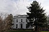 | April 29, 1982 (#82004336) | 318 High St. 41°33′32″N 72°39′20″W / 41.558889°N 72.655556°W / 41.558889; -72.655556 (Edward Augustus Russell House) | Middletown | Later ΚΝΚ fraternity, now offices of University Relations, Wesleyan University |
| 20 | Samuel Wadsworth Russell House |  | October 6, 1970 (#70000688) | 350 High St. 41°33′37″N 72°39′20″W / 41.560278°N 72.655556°W / 41.560278; -72.655556 (Samuel Wadsworth Russell House) | Middletown | Greek revival mansion, designed by Ithiel Town; now part of Wesleyan University. |
| 21 | Saint Luke's Home for Destitute and Aged Women |  | April 29, 1982 (#82004337) | 135 Pearl St. 41°33′42″N 72°39′18″W / 41.5617°N 72.6549°W / 41.5617; -72.6549 (Saint Luke's Home for Destitute and Aged Women) | Middletown | |
| 22 | Sanseer Mill |  | July 31, 1986 (#86002101) | 215 E. Main St. 41°32′59″N 72°38′31″W / 41.5497°N 72.6419°W / 41.5497; -72.6419 (Sanseer Mill) | Middletown | |
| 23 | Starr Mill |  | December 14, 1993 (#93001379) | Junction of Middlefield St. and Beverly Heights 41°32′55″N 72°41′28″W / 41.5486°N 72.6911°W / 41.5486; -72.6911 (Starr Mill) | Middletown | |
| 24 | Starr Mill Road Bridge | | December 10, 1993 (#93001344) | Starr Mill Rd. across the Cochinaug River 41°32′56″N 72°40′38″W / 41.5489°N 72.6772°W / 41.5489; -72.6772 (Starr Mill Road Bridge) | Middletown | |
| 25 | Town Farms Inn | 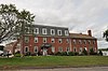 | May 4, 1979 (#79002614) | Spring St. at River Rd. 41°33′28″N 72°37′20″W / 41.5578°N 72.6222°W / 41.5578; -72.6222 (Town Farms Inn) | Middletown | |
| 26 | U.S. Post Office | 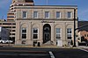 | April 12, 1982 (#82004338) | 291 Main St. 41°33′36″N 72°39′01″W / 41.56°N 72.6503°W / 41.56; -72.6503 (U.S. Post Office) | Middletown | |
| 27 | Wadsworth Estate Historic District |  | July 25, 1996 (#96000775) | 15, 30, 33, 59, 73, and 89 Laurel Grove Rd., Wadsworth Falls State Park, and 421 Wadsworth St. 41°32′02″N 72°40′44″W / 41.5339°N 72.6789°W / 41.5339; -72.6789 (Wadsworth Estate Historic District) | Middletown | |
| 28 | William and Mary Ward House | Upload image | July 27, 2021 (#100006787) | 45 Paterson Dr. 41°31′03″N 72°39′19″W / 41.5176°N 72.6552°W / 41.5176; -72.6552 (William and Mary Ward House) | Middletown | |
| 29 | Washington Street Historic District |  | May 9, 1985 (#85001018) | Roughly bounded by Washington and Main Sts., Washington Terrace, and Vine St. 41°33′41″N 72°39′31″W / 41.561389°N 72.658611°W / 41.561389; -72.658611 (Washington Street Historic District) | Middletown | |
| 30 | Seth Wetmore House |  | September 10, 1970 (#70000689) | CT 66 and Camp Rd. 41°33′09″N 72°41′19″W / 41.5525°N 72.688611°W / 41.5525; -72.688611 (Seth Wetmore House) | Middletown | |
| 31 | Wilcox, Crittenden Mill |  | December 3, 1986 (#86003349) | 234-315 S. Main St., Pameacha, and Highlands Aves. 41°32′54″N 72°39′19″W / 41.548333°N 72.655278°W / 41.548333; -72.655278 (Wilcox, Crittenden Mill) | Middletown | |
| 32 | Captain Benjamin Williams House |  | December 1, 1978 (#09000143) | 27 Washington St., 41°33′47″N 72°38′54″W / 41.563003°N 72.648428°W / 41.563003; -72.648428 (Captain Benjamin Williams House) | Middletown | |
| 33 | Woodrow Wilson High School |  | August 6, 1986 (#86002270) | Hunting Hill Ave. and Russell St. 41°32′25″N 72°38′57″W / 41.540278°N 72.649167°W / 41.540278; -72.649167 (Woodrow Wilson High School) | Middletown | |
| 34 | Xi Chapter, Psi Upsilon Fraternity |  | November 4, 2009 (#09000870) | 242 High St. 41°33′24″N 72°39′18″W / 41.556689°N 72.654908°W / 41.556689; -72.654908 (Xi Chapter, Psi Upsilon Fraternity) | Middletown | |
| 35 | YMCA of Northern Middlesex County |  | January 23, 2023 (#100008583) | 99 Union St. 41°33′24″N 72°38′48″W / 41.5568°N 72.6468°W / 41.5568; -72.6468 (YMCA of Northern Middlesex County) | Middletown |
See also
References
- ^ National Park Service, United States Department of the Interior, "National Register of Historic Places: Weekly List Actions", retrieved September 5, 2024.
- ^ Numbers represent an alphabetical ordering by significant words. Various colorings, defined here, differentiate National Historic Landmarks and historic districts from other NRHP buildings, structures, sites or objects.
- ^ "National Register Information System". National Register of Historic Places. National Park Service. March 13, 2009.
- ^ The eight-digit number below each date is the number assigned to each location in the National Register Information System database, which can be viewed by clicking the number.
Wikimedia Commons has media related to National Register of Historic Places in Middletown, Connecticut.
- v
- t
- e
- Broad Street
- Highland
- Main Street
- Metro South
- Middletown South Green
- Wadsworth Estate
- Washington Street
- Wilcox, Crittenden Mill
| K-12 |
| ||
|---|---|---|---|
| Tertiary |
| ||
| Other |
| Indiv. NRHP listings |
|
|---|---|
| Other |
|
| Closed |
|---|
This list is incomplete.
| ||
|---|---|---|
| Lists by county |  | |
| Lists by city or town | ||
| Other lists | ||


