National Register of Historic Places listings in Camden County, Georgia
This is a list of properties and districts in Camden County, Georgia that are listed on the National Register of Historic Places (NRHP).
Map all coordinates using OpenStreetMap
Download coordinates as:
- KML
- GPX (all coordinates)
- GPX (primary coordinates)
- GPX (secondary coordinates)
This National Park Service list is complete through NPS recent listings posted September 5, 2024.[1]
- v
- t
- e
Properties on the National Register of Historic Places in Georgia by county
- Appling
- Atkinson
- Bacon
- Baker
- Baldwin
- Banks
- Barrow
- Bartow
- Ben Hill
- Berrien
- Bibb
- Bleckley
- Brantley
- Brooks
- Bryan
- Bulloch
- Burke
- Butts
- Calhoun
- Camden
- Candler
- Carroll
- Catoosa
- Charlton
- Chatham
- Chattahoochee
- Chattooga
- Cherokee
- Clarke
- Clay
- Clayton
- Clinch
- Cobb
- Coffee
- Colquitt
- Columbia
- Cook
- Coweta
- Crawford
- Crisp
- Dade
- Dawson
- Decatur
- DeKalb
- Dodge
- Dooly
- Dougherty
- Douglas
- Early
- Echols
- Effingham
- Elbert
- Emanuel
- Evans
- Fannin
- Fayette
- Floyd
- Forsyth
- Franklin
- Fulton
- Gilmer
- Glascock
- Glynn
- Gordon
- Grady
- Greene
- Gwinnett
- Habersham
- Hall
- Hancock
- Haralson
- Harris
- Hart
- Heard
- Henry
- Houston
- Irwin
- Jackson
- Jasper
- Jeff Davis
- Jefferson
- Jenkins
- Johnson
- Jones
- Lamar
- Lanier
- Laurens
- Lee
- Liberty
- Lincoln
- Long
- Lowndes
- Lumpkin
- Macon
- Madison
- Marion
- McDuffie
- McIntosh
- Meriwether
- Miller
- Mitchell
- Monroe
- Montgomery
- Morgan
- Murray
- Muscogee
- Newton
- Oconee
- Oglethorpe
- Paulding
- Peach
- Pickens
- Pierce
- Pike
- Polk
- Pulaski
- Putnam
- Quitman
- Rabun
- Randolph
- Richmond
- Rockdale
- Schley
- Screven
- Seminole
- Spalding
- Stephens
- Stewart
- Sumter
- Talbot
- Taliaferro
- Tattnall
- Taylor
- Telfair
- Terrell
- Thomas
- Tift
- Toombs
- Towns
- Treutlen
- Troup
- Turner
- Twiggs
- Union
- Upson
- Walker
- Walton
- Ware
- Warren
- Washington
- Wayne
- Webster
- Wheeler
- White
- Whitfield
- Wilcox
- Wilkes
- Wilkinson
- Worth

Current listings
| [2] | Name on the Register | Image | Date listed[3] | Location | City or town | Description |
|---|---|---|---|---|---|---|
| 1 | Camden County Courthouse |  | September 18, 1980 (#80000983) | 4th and Camden Aves. 30°58′06″N 81°43′14″W / 30.96820°N 81.72069°W / 30.96820; -81.72069 (Camden County Courthouse) | Woodbine | |
| 2 | Crooked River Site (9CAM118) |  | December 23, 1985 (#85003179) | Address Restricted. | St. Marys | Is in the extreme northeastern part of Crooked River State Park[4] |
| 3 | Duck House | Upload image | February 13, 1984 (#84000938) | Cumberland Island 30°50′50″N 81°25′51″W / 30.847222°N 81.430833°W / 30.847222; -81.430833 (Duck House) | St. Marys | |
| 4 | Dungeness Historic District |  | February 13, 1984 (#84000920) | Address Restricted (on Cumberland Island) | St. Marys | |
| 5 | Greyfield | 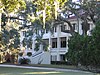 | July 24, 2003 (#03000675) | Cumberland Island 30°46′47″N 81°28′07″W / 30.77979°N 81.46854°W / 30.77979; -81.46854 (Greyfield) | ||
| 6 | High Point-Half Moon Bluff Historic District | Upload image | December 22, 1978 (#78000265) | NE of St. Marys on Cumberland Island 30°55′14″N 81°25′56″W / 30.920556°N 81.432222°W / 30.920556; -81.432222 (High Point-Half Moon Bluff Historic District) | St. Marys | |
| 7 | Kingsland Commercial Historic District |  | March 17, 1994 (#94000186) | Area surrounding S. Lee St. (US 17), between King and William Sts. 30°47′58″N 81°41′25″W / 30.7995°N 81.69014°W / 30.7995; -81.69014 (Kingsland Commercial Historic District) | Kingsland | |
| 8 | Little Cumberland Island Lighthouse | 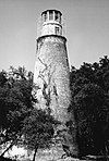 | August 28, 1989 (#89001407) | N end of Little Cumberland Island 30°58′34″N 81°24′47″W / 30.97621°N 81.41310°W / 30.97621; -81.41310 (Little Cumberland Island Lighthouse) | St. Marys | |
| 9 | Main Road |  | February 13, 1984 (#84000941) | Cumberland Island 30°49′45″N 81°27′26″W / 30.829167°N 81.457222°W / 30.829167; -81.457222 (Main Road) | St. Marys | |
| 10 | John Houstoun McIntosh Sugarhouse |  | April 2, 1992 (#92000167) | Ga. Spur 40, 6 mi. N of St. Marys, access is from Charlie Smith Hwy. (at 30°47′35″N 81°34′38″W / 30.79310°N 81.57712°W / 30.79310; -81.57712) 30°47′36″N 81°34′43″W / 30.79328°N 81.57870°W / 30.79328; -81.57870 (John Houstoun McIntosh Sugarhouse) | St. Marys | |
| 11 | Orange Hall | 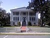 | May 7, 1973 (#73000613) | 311 Osborne St. 30°43′28″N 81°32′53″W / 30.72431°N 81.54811°W / 30.72431; -81.54811 (Orange Hall) | St. Marys | |
| 12 | Plum Orchard Historic District |  | November 23, 1984 (#84000258) | Address Restricted (on Cumberland Island) | St. Marys | |
| 13 | Rayfield Archeological District | Upload image | February 13, 1984 (#84000924) | Address Restricted | St. Marys | On Cumberland Island |
| 14 | St. Marys Historic District |  | May 13, 1976 (#76000609) | Roughly bounded by Waterfront Rd., Norris, Alexander, and Oak Grove Cemetery 30°43′24″N 81°32′53″W / 30.72323°N 81.54792°W / 30.72323; -81.54792 (St. Marys Historic District) | St. Marys | |
| 15 | Stafford Plantation |  | November 23, 1984 (#84000265) | Address Restricted (on Cumberland Island) | St. Marys | The only surviving antebellum-era structures are "the chimneys," slave cabin ruins. |
| 16 | Table Point Archeological District | Upload image | November 23, 1984 (#84000260) | Address Restricted | St. Marys | On Cumberland Island[5] |
| 17 | Woodbine Historic District | 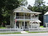 | May 12, 1999 (#99000553) | Jct. of Bedell Ave. (US 17) and 3rd and 4th Sts. and the central business district 30°58′04″N 81°43′27″W / 30.967778°N 81.724167°W / 30.967778; -81.724167 (Woodbine Historic District) | Woodbine |
References
- ^ National Park Service, United States Department of the Interior, "National Register of Historic Places: Weekly List Actions", retrieved September 5, 2024.
- ^ Numbers represent an alphabetical ordering by significant words. Various colorings, defined here, differentiate National Historic Landmarks and historic districts from other NRHP buildings, structures, sites or objects.
- ^ The eight-digit number below each date is the number assigned to each location in the National Register Information System database, which can be viewed by clicking the number.
- ^ paper abstract
- ^ NPS
Wikimedia Commons has media related to National Register of Historic Places in Camden County, Georgia.
| |
|---|---|
| Topics | |
| Lists by state |
|
| Lists by insular areas | |
| Lists by associated state | |
| Other areas | |
| Related | |
| |


