National Register of Historic Places listings in Walker County, Georgia
This is a list of properties and districts in Walker County, Georgia that are listed on the National Register of Historic Places (NRHP).
Map all coordinates using OpenStreetMap
Download coordinates as:
- KML
- GPX (all coordinates)
- GPX (primary coordinates)
- GPX (secondary coordinates)
This National Park Service list is complete through NPS recent listings posted September 5, 2024.[1]
- v
- t
- e
Properties on the National Register of Historic Places in Georgia by county
- Appling
- Atkinson
- Bacon
- Baker
- Baldwin
- Banks
- Barrow
- Bartow
- Ben Hill
- Berrien
- Bibb
- Bleckley
- Brantley
- Brooks
- Bryan
- Bulloch
- Burke
- Butts
- Calhoun
- Camden
- Candler
- Carroll
- Catoosa
- Charlton
- Chatham
- Chattahoochee
- Chattooga
- Cherokee
- Clarke
- Clay
- Clayton
- Clinch
- Cobb
- Coffee
- Colquitt
- Columbia
- Cook
- Coweta
- Crawford
- Crisp
- Dade
- Dawson
- Decatur
- DeKalb
- Dodge
- Dooly
- Dougherty
- Douglas
- Early
- Echols
- Effingham
- Elbert
- Emanuel
- Evans
- Fannin
- Fayette
- Floyd
- Forsyth
- Franklin
- Fulton
- Gilmer
- Glascock
- Glynn
- Gordon
- Grady
- Greene
- Gwinnett
- Habersham
- Hall
- Hancock
- Haralson
- Harris
- Hart
- Heard
- Henry
- Houston
- Irwin
- Jackson
- Jasper
- Jeff Davis
- Jefferson
- Jenkins
- Johnson
- Jones
- Lamar
- Lanier
- Laurens
- Lee
- Liberty
- Lincoln
- Long
- Lowndes
- Lumpkin
- Macon
- Madison
- Marion
- McDuffie
- McIntosh
- Meriwether
- Miller
- Mitchell
- Monroe
- Montgomery
- Morgan
- Murray
- Muscogee
- Newton
- Oconee
- Oglethorpe
- Paulding
- Peach
- Pickens
- Pierce
- Pike
- Polk
- Pulaski
- Putnam
- Quitman
- Rabun
- Randolph
- Richmond
- Rockdale
- Schley
- Screven
- Seminole
- Spalding
- Stephens
- Stewart
- Sumter
- Talbot
- Taliaferro
- Tattnall
- Taylor
- Telfair
- Terrell
- Thomas
- Tift
- Toombs
- Towns
- Treutlen
- Troup
- Turner
- Twiggs
- Union
- Upson
- Walker
- Walton
- Ware
- Warren
- Washington
- Wayne
- Webster
- Wheeler
- White
- Whitfield
- Wilcox
- Wilkes
- Wilkinson
- Worth

Current listings
| [2] | Name on the Register | Image | Date listed[3] | Location | City or town | Description |
|---|---|---|---|---|---|---|
| 1 | Ashland Farm | Upload image | October 18, 1973 (#73000646) | SW of Rossville off GA 193 34°57′16″N 85°20′46″W / 34.954444°N 85.346111°W / 34.954444; -85.346111 (Ashland Farm) | Rossville | gated |
| 2 | Cavender's Store | 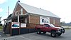 | March 20, 1992 (#92000143) | Jct. of GA 201 and GA 136, SW corner 34°40′25″N 85°06′54″W / 34.673611°N 85.115°W / 34.673611; -85.115 (Cavender's Store) | Villanow | |
| 3 | Chattooga Academy |  | February 15, 1980 (#80001253) | 306 N. Main St. 34°42′31″N 85°16′51″W / 34.708611°N 85.280833°W / 34.708611; -85.280833 (Chattooga Academy) | LaFayette | |
| 4 | Chickamauga and Chattanooga National Military Park |  | October 15, 1966 (#66000274) | S of Chattanooga on U.S. 27 34°58′09″N 85°17′07″W / 34.9692°N 85.2853°W / 34.9692; -85.2853 (Chickamauga and Chattanooga National Military Park) | Wildwood | administered by the National Park Service |
| 5 | Chickamauga Coal and Iron Company Coke Ovens | 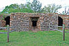 | April 9, 2009 (#09000188) | Georgia State Route 341 34°52′53″N 85°17′43″W / 34.8814°N 85.2953°W / 34.8814; -85.2953 (Chickamauga Coal and Iron Company Coke Ovens) | Chickamauga | |
| 6 | Chickamauga Historic District | 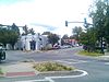 | July 20, 2007 (#07000700) | Roughly centered on Cove Rd. and bounded by Crescent, Pearl, & 6th Sts. and the Central of Georgia RR 34°52′02″N 85°17′39″W / 34.867351°N 85.294265°W / 34.867351; -85.294265 (Chickamauga Historic District) | Chickamauga | |
| 7 | Chickamauga Lodge No. 221, Free and Accepted Masons, Prince Hall Affiliate | 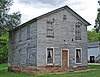 | August 30, 2006 (#06000736) | 1378 GA 341 S 34°51′24″N 85°18′19″W / 34.8567°N 85.3053°W / 34.8567; -85.3053 (Chickamauga Lodge No. 221, Free and Accepted Masons, Prince Hall Affiliate) | Chickamauga | |
| 8 | Gordon-Lee House |  | March 22, 1976 (#76000654) | 217 Cove Rd. 34°52′19″N 85°17′41″W / 34.87181°N 85.29479°W / 34.87181; -85.29479 (Gordon-Lee House) | Chickamauga | Antebellum plantation house, included in Chickamauga Historic District |
| 9 | Lane House |  | December 12, 1976 (#76000655) | Weathers Dr., east of Kensington[4] 34°46′43″N 85°20′24″W / 34.7786°N 85.34°W / 34.7786; -85.34 (Lane House) | Kensington | |
| 10 | Lee and Gordon Mill | 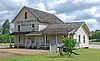 | February 8, 1980 (#80001252) | Red Belt Rd. 34°53′01″N 85°16′01″W / 34.8836°N 85.2669°W / 34.8836; -85.2669 (Lee and Gordon Mill) | Chickamauga | |
| 11 | Lookout Mountain Fairyland Club |  | June 21, 1990 (#90000991) | 1201 Fleetwood Dr. 34°58′31″N 85°20′55″W / 34.9753°N 85.3486°W / 34.9753; -85.3486 (Lookout Mountain Fairyland Club) | Lookout Mountain | |
| 12 | Marsh-Warthen House | 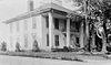 | January 12, 2005 (#04001467) | N. Main St. 34°42′33″N 85°16′52″W / 34.7092°N 85.2811°W / 34.7092; -85.2811 (Marsh-Warthen House) | LaFayette | |
| 13 | McLemore Cove Historic District | 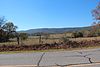 | September 23, 1994 (#94001140) | 3 mi. S of Chickamauga, in an area roughly bounded by Lookout and Pigeon Mtns., and GA 136 34°44′22″N 85°23′13″W / 34.739444°N 85.386944°W / 34.739444; -85.386944 (McLemore Cove Historic District) | Kensington | |
| 14 | Miller Brothers Farm | Upload image | August 6, 1987 (#87001332) | GA 912 34°46′23″N 85°22′32″W / 34.773056°N 85.375556°W / 34.773056; -85.375556 (Miller Brothers Farm) | Kensington | |
| 15 | Rock City Gardens |  | September 17, 2014 (#14000619) | 1400 Patton Rd. 34°58′26″N 85°20′55″W / 34.973889°N 85.348611°W / 34.973889; -85.348611 (Rock City Gardens) | Lookout Mountain | |
| 16 | John Ross House |  | November 7, 1973 (#73000647) | Lake Ave. and Spring St. 34°58′52″N 85°17′05″W / 34.98110°N 85.28478°W / 34.98110; -85.28478 (John Ross House) | Rossville | |
| 17 | US Post Office-Rossville Main |  | August 6, 1986 (#86002272) | 301 Chickamauga Ave. 34°58′59″N 85°17′11″W / 34.983056°N 85.286389°W / 34.983056; -85.286389 (US Post Office-Rossville Main) | Rossville | |
| 18 | Walker County Courthouse |  | September 18, 1980 (#80001254) | Duke St. 34°42′15″N 85°16′50″W / 34.704167°N 85.280556°W / 34.704167; -85.280556 (Walker County Courthouse) | LaFayette |
References
Wikimedia Commons has media related to National Register of Historic Places in Walker County, Georgia.
- ^ National Park Service, United States Department of the Interior, "National Register of Historic Places: Weekly List Actions", retrieved September 5, 2024.
- ^ Numbers represent an alphabetical ordering by significant words. Various colorings, defined here, differentiate National Historic Landmarks and historic districts from other NRHP buildings, structures, sites or objects.
- ^ The eight-digit number below each date is the number assigned to each location in the National Register Information System database, which can be viewed by clicking the number.
- ^ Location derived from its coordinates; the NRIS provides coordinates but lists the property as "Address Restricted"


