National Register of Historic Places listings in Wilkes County, Georgia
This is a list of properties and districts in Wilkes County, Georgia that are listed on the National Register of Historic Places (NRHP).
Map all coordinates using OpenStreetMap
Download coordinates as:
- KML
- GPX (all coordinates)
- GPX (primary coordinates)
- GPX (secondary coordinates)
This National Park Service list is complete through NPS recent listings posted September 5, 2024.[1]
- v
- t
- e
Properties on the National Register of Historic Places in Georgia by county
- Appling
- Atkinson
- Bacon
- Baker
- Baldwin
- Banks
- Barrow
- Bartow
- Ben Hill
- Berrien
- Bibb
- Bleckley
- Brantley
- Brooks
- Bryan
- Bulloch
- Burke
- Butts
- Calhoun
- Camden
- Candler
- Carroll
- Catoosa
- Charlton
- Chatham
- Chattahoochee
- Chattooga
- Cherokee
- Clarke
- Clay
- Clayton
- Clinch
- Cobb
- Coffee
- Colquitt
- Columbia
- Cook
- Coweta
- Crawford
- Crisp
- Dade
- Dawson
- Decatur
- DeKalb
- Dodge
- Dooly
- Dougherty
- Douglas
- Early
- Echols
- Effingham
- Elbert
- Emanuel
- Evans
- Fannin
- Fayette
- Floyd
- Forsyth
- Franklin
- Fulton
- Gilmer
- Glascock
- Glynn
- Gordon
- Grady
- Greene
- Gwinnett
- Habersham
- Hall
- Hancock
- Haralson
- Harris
- Hart
- Heard
- Henry
- Houston
- Irwin
- Jackson
- Jasper
- Jeff Davis
- Jefferson
- Jenkins
- Johnson
- Jones
- Lamar
- Lanier
- Laurens
- Lee
- Liberty
- Lincoln
- Long
- Lowndes
- Lumpkin
- Macon
- Madison
- Marion
- McDuffie
- McIntosh
- Meriwether
- Miller
- Mitchell
- Monroe
- Montgomery
- Morgan
- Murray
- Muscogee
- Newton
- Oconee
- Oglethorpe
- Paulding
- Peach
- Pickens
- Pierce
- Pike
- Polk
- Pulaski
- Putnam
- Quitman
- Rabun
- Randolph
- Richmond
- Rockdale
- Schley
- Screven
- Seminole
- Spalding
- Stephens
- Stewart
- Sumter
- Talbot
- Taliaferro
- Tattnall
- Taylor
- Telfair
- Terrell
- Thomas
- Tift
- Toombs
- Towns
- Treutlen
- Troup
- Turner
- Twiggs
- Union
- Upson
- Walker
- Walton
- Ware
- Warren
- Washington
- Wayne
- Webster
- Wheeler
- White
- Whitfield
- Wilcox
- Wilkes
- Wilkinson
- Worth

Current listings
| [2] | Name on the Register | Image | Date listed[3] | Location | City or town | Description |
|---|---|---|---|---|---|---|
| 1 | Anderson House | 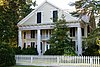 | September 29, 1976 (#76000657) | GA 44 33°52′05″N 82°39′10″W / 33.868°N 82.6527°W / 33.868; -82.6527 (Anderson House) | Danburg | |
| 2 | Arnold-Callaway Plantation |  | April 11, 1972 (#72000402) | NW of Washington on U.S. 78 33°46′27″N 82°48′46″W / 33.774167°N 82.812778°W / 33.774167; -82.812778 (Arnold-Callaway Plantation) | Washington | Also known as the Callaway Plantation. |
| 3 | Campbell-Jordan House |  | July 14, 1971 (#71000288) | 208 Liberty St. 33°44′09″N 82°44′14″W / 33.73571°N 82.73728°W / 33.73571; -82.73728 (Campbell-Jordan House) | Washington | |
| 4 | The Cedars |  | April 11, 1972 (#72000403) | 210 Sims St. 33°44′29″N 82°44′19″W / 33.741389°N 82.738611°W / 33.741389; -82.738611 (The Cedars) | Washington | |
| 5 | Cherry Grove Baptist Church Schoolhouse |  | June 23, 2020 (#100005300) | 1878 Danburg Rd. 33°46′04″N 82°41′55″W / 33.76769°N 82.69848°W / 33.76769; -82.69848 (Cherry Grove Baptist Church Schoolhouse) | Washington vicinity | |
| 6 | James and Cunningham Daniel House |  | November 24, 1980 (#80001266) | S of Rayle on Bartram Trace Rd. 33°41′00″N 82°54′29″W / 33.68335°N 82.90803°W / 33.68335; -82.90803 (James and Cunningham Daniel House) | Rayle | |
| 7 | East Robert Toombs Historic District | 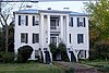 | April 11, 1972 (#72000404) | East Robert Toombs Ave. between Alexander Ave. and Grove St. 33°44′12″N 82°44′12″W / 33.736667°N 82.736667°W / 33.736667; -82.736667 (East Robert Toombs Historic District) | Washington | |
| 8 | Fitzpatrick Hotel |  | December 17, 1982 (#82000147) | 18 W. Public Square 33°44′14″N 82°44′24″W / 33.737222°N 82.74°W / 33.737222; -82.74 (Fitzpatrick Hotel) | Washington | |
| 9 | Gartrell Family House | Upload image | June 14, 2002 (#02000629) | 854 Boyd Rd. 33°55′28″N 82°46′24″W / 33.924444°N 82.773333°W / 33.924444; -82.773333 (Gartrell Family House) | Tignall | |
| 10 | Gilbert-Alexander House |  | April 11, 1972 (#72000405) | 116 Alexander Dr. 33°44′28″N 82°44′14″W / 33.741111°N 82.737222°W / 33.741111; -82.737222 (Gilbert-Alexander House) | Washington | |
| 11 | Thomas M. Gilmer House | Upload image | November 2, 1977 (#77001540) | 5 miles (8.0 km) W of Washington on U.S. 78 33°58′38″N 82°50′07″W / 33.977222°N 82.835278°W / 33.977222; -82.835278 (Thomas M. Gilmer House) | Washington | |
| 12 | Holly Court |  | April 11, 1972 (#72000406) | 301 S. Alexander St. 33°44′00″N 82°44′12″W / 33.733333°N 82.736667°W / 33.733333; -82.736667 (Holly Court) | Washington | |
| 13 | Kettle Creek Battlefield |  | June 26, 1975 (#75000617) | 9 miles (14 km) SW of Washington off Tyrone Rd. 33°41′26″N 82°53′11″W / 33.690556°N 82.886389°W / 33.690556; -82.886389 (Kettle Creek Battlefield) | Washington | |
| 14 | Mary Willis Library |  | April 11, 1972 (#72000407) | 204 E. Liberty (at S. Jefferson St.) 33°44′07″N 82°44′17″W / 33.735278°N 82.738056°W / 33.735278; -82.738056 (Mary Willis Library) | Washington | |
| 15 | North Washington District | Upload image | March 7, 1973 (#73000649) | Bounded by Jefferson and Court Sts., Poplar Dr., and U.S. 78 33°44′40″N 82°44′22″W / 33.744444°N 82.739444°W / 33.744444; -82.739444 (North Washington District) | Washington | |
| 16 | Old Jail |  | June 5, 1974 (#74000706) | 103 Court St. 33°44′20″N 82°44′28″W / 33.738889°N 82.741111°W / 33.738889; -82.741111 (Old Jail) | Washington | |
| 17 | Peacewood | Upload image | April 11, 1972 (#72000408) | 120 Tignall Rd. 33°45′15″N 82°44′01″W / 33.75415°N 82.73359°W / 33.75415; -82.73359 (Peacewood) | Washington | |
| 18 | Pharr-Callaway-Sethness House | 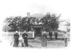 | March 26, 1976 (#76000659) | N of Tignall on GA 2193 33°56′14″N 82°44′12″W / 33.937222°N 82.736667°W / 33.937222; -82.736667 (Pharr-Callaway-Sethness House) | Tignall | The house seems to be gone as of 2020. |
| 19 | Poplar Corner |  | April 11, 1972 (#72000409) | 210 W. Liberty St. 33°44′09″N 82°44′33″W / 33.73585°N 82.74249°W / 33.73585; -82.74249 (Poplar Corner) | Washington | |
| 20 | Robert Shand Smith House | 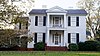 | November 7, 2002 (#02001294) | 902 S. Spring St. 33°43′34″N 82°44′31″W / 33.72623°N 82.74202°W / 33.72623; -82.74202 (Robert Shand Smith House) | Washington | |
| 21 | Robert Toombs House |  | April 11, 1972 (#72000410) | 216 E. Robert Toombs Ave. 33°44′10″N 82°44′02″W / 33.73616°N 82.73387°W / 33.73616; -82.73387 (Robert Toombs House) | Washington | A National Historic Landmark and a Georgia state historic site |
| 22 | Tupper-Barnett House |  | April 11, 1972 (#72000411) | 101 W. Robert Toombs Ave. 33°44′14″N 82°44′28″W / 33.73730°N 82.74103°W / 33.73730; -82.74103 (Tupper-Barnett House) | Washington | National Historic Landmark |
| 23 | Washington Commercial Historic District |  | March 6, 1986 (#86000412) | Roughly bounded by Court St., Jefferson St., Robert Toombs Ave., and Allison St. 33°44′14″N 82°44′22″W / 33.737222°N 82.739444°W / 33.737222; -82.739444 (Washington Commercial Historic District) | Washington | |
| 24 | Washington Historic District | Upload image | December 6, 2004 (#04001319) | Centered on West Robert Toombs Ave. and N. Alexander St. 33°44′07″N 82°44′34″W / 33.735278°N 82.742778°W / 33.735278; -82.742778 (Washington Historic District) | Washington | |
| 25 | Washington Presbyterian Church |  | April 11, 1972 (#72000412) | 206 E. Robert Toombs Ave. 33°44′08″N 82°44′10″W / 33.735556°N 82.736111°W / 33.735556; -82.736111 (Washington Presbyterian Church) | Washington | |
| 26 | Washington-Wilkes Historical Museum |  | May 13, 1970 (#70000227) | 308 E. Robert Toombs Ave. 33°44′07″N 82°44′03″W / 33.735278°N 82.734167°W / 33.735278; -82.734167 (Washington-Wilkes Historical Museum) | Washington | |
| 27 | West Robert Toombs District | Upload image | March 1, 1973 (#73000650) | W. Robert Toombs Ave. between Allison St. and Rte. 44 and Lexington Ave. 33°44′10″N 82°44′50″W / 33.736111°N 82.747222°W / 33.736111; -82.747222 (West Robert Toombs District) | Washington | |
| 28 | Wilkes County Courthouse |  | September 18, 1980 (#80001267) | Court St. 33°44′17″N 82°44′22″W / 33.738056°N 82.739444°W / 33.738056; -82.739444 (Wilkes County Courthouse) | Washington | |
| 29 | Willis-Sale-Stennett House |  | October 14, 1976 (#76000658) | N of Danburg off GA 79 on SR 1445 (Delhi Road) 33°55′20″N 82°39′04″W / 33.9221°N 82.6511°W / 33.9221; -82.6511 (Willis-Sale-Stennett House) | Danburg |
References
- ^ National Park Service, United States Department of the Interior, "National Register of Historic Places: Weekly List Actions", retrieved September 5, 2024.
- ^ Numbers represent an alphabetical ordering by significant words. Various colorings, defined here, differentiate National Historic Landmarks and historic districts from other NRHP buildings, structures, sites or objects.
- ^ The eight-digit number below each date is the number assigned to each location in the National Register Information System database, which can be viewed by clicking the number.
Wikimedia Commons has media related to National Register of Historic Places in Wilkes County, Georgia.


